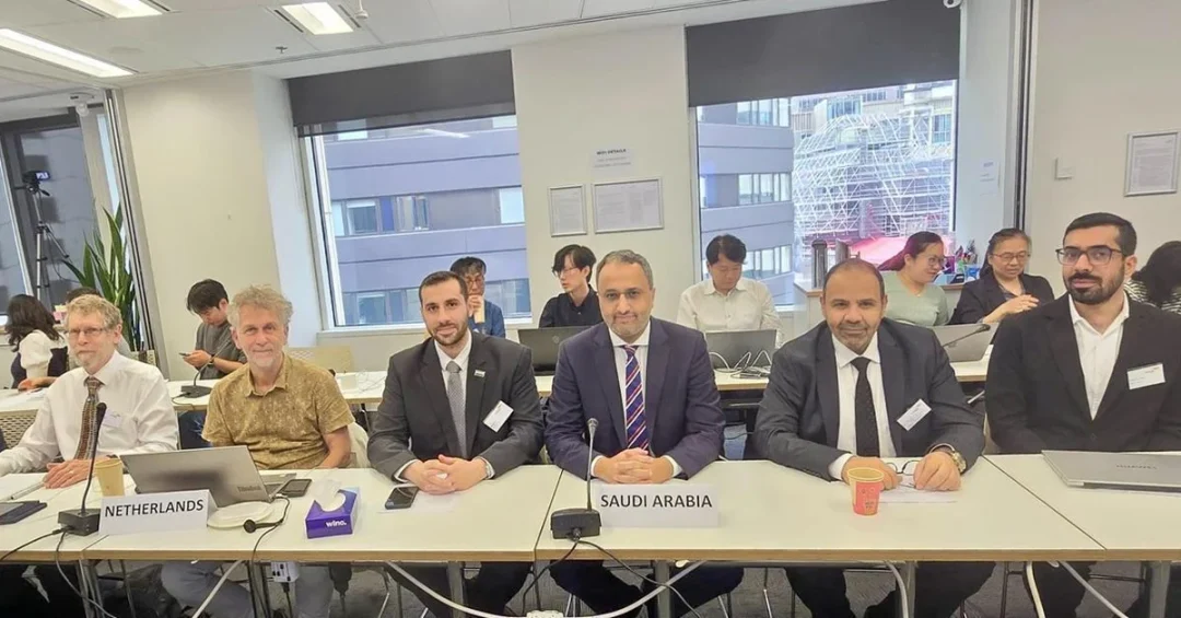
The General Authority for Survey and Geospatial Information (GEOSA) led the Kingdom of Saudi Arabia’s delegation to the 59th meeting of the Technical Committee for Geospatial Information at the International Organization for Standardization (ISO), held from November 11 to 15, 2024, in Sydney, Australia. This participation underscores Saudi Arabia’s growing role in shaping global geospatial standards and advancing its digital infrastructure under Vision 2030.
Context and Background
GEOSA, the national authority responsible for surveying, mapping, and geospatial data in Saudi Arabia, has been actively engaging with international bodies to align the Kingdom’s practices with global benchmarks. The ISO Technical Committee for Geospatial Information develops and maintains standards that facilitate the interoperability and widespread use of geospatial data worldwide. Saudi Arabia’s presence at this meeting reflects its commitment to contributing to these global standards while ensuring its national data layers meet international requirements.
Key Details
During the meeting, the Saudi delegation, led by GEOSA, presented draft specifications for the Kingdom’s national basic geospatial layers data. These specifications were introduced before a group of global specialists in geospatial standards, highlighting Saudi Arabia’s progress in developing standardized spatial data infrastructure. The presentation aimed to gather feedback and ensure alignment with ISO frameworks, which are critical for data sharing and integration across sectors such as urban planning, transportation, and environmental management.
Implications and Impact
Saudi Arabia’s active participation in the ISO meeting reinforces its reputation as a key player in the global geospatial community. By contributing to international standards, the Kingdom enhances its ability to attract investment in smart city projects, geographic information systems (GIS), and digital transformation initiatives. This engagement also facilitates collaboration with other nations and international organizations, supporting economic diversification and technological innovation. The adoption of standardized geospatial data layers is essential for efficient land management, disaster response, and sustainable development within the Kingdom.
Vision 2030 Alignment
The GEOSA-led participation aligns closely with Saudi Vision 2030, which prioritizes digital transformation, data-driven governance, and economic diversification. By developing nationally standardized geospatial layers and contributing to ISO standards, Saudi Arabia is building a foundational digital infrastructure that supports smart cities, improves government services, and enhances the quality of life for citizens and residents. This commitment to global best practices positions the Kingdom as a regional leader in geospatial technology and a reliable partner in international standardization efforts.
20 Questions
Q1. What is GEOSA?
A1. GEOSA stands for the General Authority for Survey and Geospatial Information, the Saudi government body responsible for national surveying, mapping, and geospatial data management.
Q2. What was the purpose of the ISO meeting in Sydney?
A2. The 59th meeting of the ISO Technical Committee for Geospatial Information aimed to develop and update global standards for geospatial data, ensuring interoperability and quality worldwide.
Q3. How many days did the meeting last?
A3. The meeting took place over five days, from November 11 to 15, 2024, in Sydney, Australia.
Q4. What did the Saudi delegation present at the meeting?
A4. The delegation presented draft specifications for the Kingdom’s national basic geospatial layers data, outlining standardized frameworks for spatial data infrastructure.
Q5. Why is Saudi Arabia participating in ISO geospatial meetings?
A5. Participation ensures Saudi Arabia’s geospatial standards align with global norms, facilitating data sharing, attracting investment, and supporting digital transformation goals under Vision 2030.
Q6. What is the significance of the ISO Technical Committee for Geospatial Information?
A6. The committee develops international standards that enable consistent and reliable use of geospatial data across different systems and countries, promoting global cooperation.
Q7. How does this event support Vision 2030?
A7. It advances Vision 2030’s digital transformation pillar by building standardized geospatial infrastructure, which is crucial for smart cities, governance, and economic diversification.
Q8. Who led the Saudi delegation to Sydney?
A8. The delegation was led by representatives from the General Authority for Survey and Geospatial Information (GEOSA), the national geospatial authority.
Q9. What are national basic geospatial layers data?
A9. These are fundamental spatial datasets, such as terrain, administrative boundaries, and transportation networks, serving as the foundation for geographic information systems.
Q10. How many countries participated in the meeting?
A10. The specific number is not disclosed, but the ISO committee includes representatives from dozens of member countries with expertise in geospatial standards.
Q11. What benefits do standardized geospatial layers bring to Saudi Arabia?
A11. They improve data accuracy, enable efficient urban planning, support disaster management, and enhance integration with international systems for trade and development.
Q12. Was this Saudi Arabia’s first participation in such an ISO meeting?
A12. Not necessarily; Saudi Arabia has been actively engaging with ISO geospatial committees for several years, reflecting its ongoing commitment to global standards.
Q13. How does GEOSA contribute to Saudi Arabia’s digital economy?
A13. GEOSA provides reliable geospatial data that powers applications in logistics, smart cities, and e-government, all vital for a knowledge-based economy.
Q14. What types of specialists attended the meeting in Sydney?
A14. The meeting brought together global experts in geospatial standards, including representatives from national mapping agencies, technology firms, and academic institutions.
Q15. How does standardized geospatial data impact international collaboration?
A15. It allows different countries to share and integrate spatial data seamlessly, fostering cooperation in areas like climate monitoring, infrastructure projects, and humanitarian aid.
Q16. Is Saudi Arabia’s geospatial sector growing?
A16. Yes, the sector is expanding rapidly, driven by investments in digital infrastructure, smart city initiatives, and the broader Vision 2030 transformation plan.
Q17. What other international geospatial bodies does Saudi Arabia work with?
A17. Saudi Arabia collaborates with organizations like the United Nations Global Geospatial Information Management (UN-GGIM) and regional geospatial networks.
Q18. How does this participation strengthen Saudi Arabia’s global role?
A18. It demonstrates Saudi leadership in shaping international standards, enhancing its reputation as a reliable partner in technology and innovation.
Q19. What are the next steps after presenting the draft specifications?
A19. The draft will be reviewed by ISO experts, and feedback will be incorporated to finalize the specifications, which may then become part of international standards.
Q20. Where can readers find more information about GEOSA’s work?
A20. Readers can visit the official GEOSA website or follow announcements from the Saudi Press Agency for updates on geospatial initiatives and international engagements.
Reader Feedback
We value your thoughts. Please share your feedback on this article.
Your feedback helps us improve our coverage.