


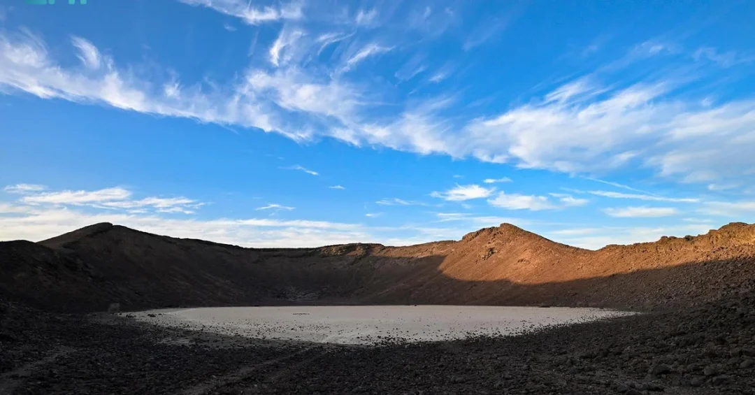
Saudi Arabia’s volcanic “Fire Forts,” known locally as Harrat, date back approximately 30 million years and stand as natural archaeological records revealing the deep history of the Arabian Peninsula, according to Professor of History and Archeology Dr. Hammad Al-Ruwaili. These black volcanic stone formations, scattered across the Kingdom and concentrated north of Taif, offer a unique window into the civilizations that once thrived on this ancient land, the Saudi Press Agency (SPA) reported.
Context and Background
The Harrat, which translates to “hot places” or “fire forts,” are volcanic fields formed by basaltic lava eruptions over millions of years. Dr. Al-Ruwaili explained that the history of volcanoes in Saudi Arabia goes back about 30 million years, formed in two distinct stages: the first coincided with the eruption of basalt lava and the emergence of the Red Sea, while the second began with volcanic activity in the Arabian Peninsula around 10 million years ago.
These geological wonders are found in various regions, including Makkah, Madinah, the Northern Borders, Asir, Hail, Al-Baha, Tabuk, and Al-Jawf. The largest volcano by area is Harrat Rahat, followed by Harrat Khaybar, Harrat al-Hurrah, and Harrat Nawasif. The Black Harrats north of Taif—such as Hafar Kashab, Turbah, Al-Khurma, and Al-Muwayh—are particularly significant for their well-preserved formations and historical richness.
Key Details
Among the most notable features is Harrat Hafar Kishb, which includes Al-Wabah crater, known as the “alluvial quarry.” This is the deepest volcanic crater in Saudi Arabia, with a diameter of more than 2 kilometers and a depth of 220 meters. It has become a tourist destination attracting international, regional, and local visitors. Dr. Al-Ruwaili noted that volcanoes come in various types, including volcanic domes, scoria stones, shield volcanoes, and volcanic craters.
Hafar Kashab was named after Mount Kashab, located approximately 260 kilometers northeast of Taif Governorate. It is a black mountain visible to travelers on the Riyadh Road after Al-Muwayh. The area is characterized by scattered black stones interspersed with soil, known as “the bottoms,” and includes sites like Dughaybjah, Al-Khawara, Al-Hafar, Al-Mashubah, Qia, Maran, and Al-Muwayh. To the east lies a harsh desert where walking is extremely difficult. SPA photographers documented the landmarks of populations that settled on these solid lava fields, beneath which valleys and water courses harbor rare aromatic medicinal plants.
Implications and Impact
The Fire Forts are more than geological curiosities; they are natural archaeological records that reveal the past and coexist with the present. They provide a glimpse into the civilizational development of the peoples who lived there, explaining their life, behavior, culture, customs, and traditions. These areas breathe the fragrance of the past, around which legends and love stories were narrated. The unique geography—caves, hills, mountains, plateaus, valleys, and plains—has witnessed the history, civilization, heritage, and antiquities of the region.
As Saudi Arabia continues to open up to tourism under Vision 2030, sites like Harrat Hafar Kishb are becoming important pillars of tourism and development. The Kingdom’s rich geological and cultural heritage offers a unique appeal to international travelers seeking authentic and educational experiences. The documentation and promotion of these sites align with the National Tourism Strategy, which aims to diversify the economy and attract 100 million visitors annually by 2030.
Vision 2030 Alignment
The exploration and preservation of the Fire Forts exemplify Saudi Arabia’s commitment to showcasing its historical depth and natural wonders as part of Vision 2030. By integrating these ancient landscapes into the tourism and cultural sectors, the Kingdom not only preserves its heritage but also creates economic opportunities and promotes cross-cultural understanding. As the world discovers the 30-million-year-old story etched in the Harrat, Saudi Arabia reinforces its role as a guardian of Arabian heritage and a forward-looking global destination.
20 Questions
Q1. What are the “Fire Forts” in Saudi Arabia?
A1. The “Fire Forts” are volcanic stone formations known locally as Harrat, which means “hot places.” They are natural archaeological records that reveal the history of the Arabian Peninsula.
Q2. How old are the volcanoes in Saudi Arabia?
A2. According to Dr. Hammad Al-Ruwaili, the history of volcanoes in Saudi Arabia goes back approximately 30 million years.
Q3. In how many stages were the Saudi volcanoes formed?
A3. They were formed in two stages: the first coincided with the eruption of basalt lava and the emergence of the Red Sea, and the second began 10 million years ago.
Q4. Where are the Black Harrats mostly found?
A4. The Black Harrats are scattered all over the Kingdom but are mostly found north of Taif, including areas like Hafar Kashab, Turbah, Al-Khurma, and Al-Muwayh.
Q5. What is the largest volcano in Saudi Arabia by area?
A5. Harrat Rahat is the largest volcano in terms of area, followed by Harrat Khaybar, Harrat al-Hurrah, and Harrat Nawasif.
Q6. What is special about Al-Wabah crater?
A6. Al-Wabah crater, part of Harrat Hafar Kishb, is the deepest volcanic crater in Saudi Arabia, with a diameter of over 2 kilometers and a depth of 220 meters.
Q7. Is Al-Wabah crater a tourist destination?
A7. Yes, it is now a tourist destination visited by international, regional, and local tourists.
Q8. What are the different types of volcanoes mentioned?
A8. The types include volcanic domes, scoria stones, shield volcanoes, and volcanic craters.
Q9. Why is Hafar Kashab named as such?
A9. It is named after Mount Kashab, a black mountain located approximately 260 kilometers northeast of Taif Governorate.
Q10. What can travelers see on Riyadh Road after Al-Muwayh?
A10. They can see the black mountain of Mount Kashab on their right.
Q11. What are “the bottoms” in the context of Harrat?
A11. “The bottoms” refer to areas of scattered black stones interspersed with soil, found in places like Dughaybjah, Al-Khawara, Al-Hafar, and others.
Q12. What lies to the east of Hafar Kashab?
A12. To the east lies a harsh desert where walking is either impossible or extremely difficult.
Q13. What did SPA photographers document?
A13. They documented the most important landmarks of populations that settled on the solid lava fields, including valleys and water courses with rare aromatic medicinal plants.
Q14. Why are the Fire Forts important for understanding Arabian history?
A14. They provide a glimpse into the civilizational development of ancient peoples, explaining their life, culture, customs, and traditions.
Q15. How do the Harrat contribute to tourism in Saudi Arabia?
A15. Sites like Harrat Hafar Kishb have become important pillars of tourism and development, attracting visitors and supporting Vision 2030 goals.
Q16. What role do the Fire Forts play in Vision 2030?
A16. They help diversify the economy, preserve heritage, and attract tourists, aligning with the National Tourism Strategy to welcome 100 million visitors annually by 2030.
Q17. What kind of geography is found in the Harrat areas?
A17. The areas feature caves, hills, mountains, plateaus, valleys, and plains that have witnessed the region’s history and civilization.
Q18. Are there legends associated with the Fire Forts?
A18. Yes, legends and love stories have been narrated around these ancient landscapes, adding to their cultural significance.
Q19. Which regions in Saudi Arabia have volcanic activity?
A19. Volcanic activity is found in Makkah, Madinah, the Northern Borders, Asir, Hail, Al-Baha, Tabuk, and Al-Jawf regions.
Q20. How can visitors experience the Fire Forts?
A20. Visitors can explore sites like Harrat Hafar Kishb and Al-Wabah crater, which are accessible and promoted as unique tourist destinations in Saudi Arabia.
Reader Feedback
We value your thoughts. Please share your feedback on this article.
Your feedback helps us improve our coverage.
Related articles
 Batman Takes Over Jeddah Season with Warner Bros. Discovery
 Book Plateau: A Timeless Treasure in Al-Baha Region
 Taif Summer Offers Exquisite Destinations in Mild Climate
 Holy Rawdah: A Masterpiece of Islamic Art and Architecture
 Aqabat Shaar: The Lifeline of Asir’s Rugged Beauty
 South Obhur Beach: Jeddah’s Summer Haven for Visitors