


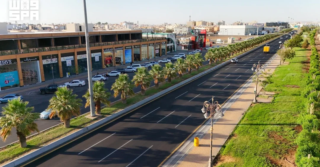
Urban development in Tabuk now spans an approved area of 417 square kilometers, according to data released by the Tabuk Region Municipality and carried by the Saudi Press Agency (SPA), covering residential neighborhoods, the city center, housing projects, parks, walkways, and upgraded public spaces. The figures, published on October 18, 2026, offer one of the clearest pictures yet of how a mid-sized Saudi city is being reshaped under the Kingdom’s long-term planning framework, with the municipality reporting progress across housing handovers, land development, and recreational infrastructure at the same time.
For international observers tracking Saudi Arabia’s urban transformation beyond the headline megaprojects, Tabuk has become a useful case study. The city sits in the northwest of the Kingdom, close to the Red Sea coast and the borders with Jordan and Egypt’s Sinai across the Gulf of Aqaba, and it functions as a gateway for religious and leisure travelers moving between the coast and the interior. What is happening there — new residential units, serviced plots, pedestrian routes, and green space — reflects the same priorities that animate national programs: livable cities, diversified local economies, and a better quality of life for a growing population. But how does a city of this size absorb such a large program without losing its character? The municipality’s own data suggests the answer lies in sequencing: hand over homes, open land for building, and stitch neighborhoods together with public space.
Context and Background
Why does a 417-square-kilometer urban footprint matter for a city like Tabuk? The approved urban area defines where services, roads, utilities, and zoning will be concentrated, and it sets the boundaries within which the municipality plans schools, clinics, parks, and transport links. According to the Tabuk Region Municipality, the city currently has 58 designated neighborhoods, with plans to increase that number to 68. That expansion is not simply a matter of drawing lines on a map; each new neighborhood requires water networks, electricity, road connections, and community facilities before residents can move in.
The municipality’s data also reflects a deliberate approach to housing supply. The real estate portfolio comprises 11 projects offering a total of 5,050 residential units, spread across the Al-Masyaf, Anwar Al-Qadisiyah, and Al-Nazim neighborhoods. These projects are at various stages, ranging from completed handovers to active construction, which means the city is adding housing stock in phases rather than in a single burst. Phased delivery matters because it allows utilities, roads, and public services to keep pace with new residents, reducing the risk of the infrastructure bottlenecks that have affected fast-growing cities elsewhere in the region.
Tabuk’s position in Saudi planning is also significant. The city is the administrative center of the Tabuk Region and has long served as a commercial and logistical hub for the northwest. Its proximity to the Red Sea and to major north-south routes gives it a role in freight movement and in domestic tourism, particularly for visitors heading to coastal destinations and heritage sites. As the Kingdom invests in transport links and tourism infrastructure, cities like Tabuk become nodes in a wider network rather than isolated population centers. That context helps explain why municipal projects there are being tracked closely by planners and investors alike.
Key Details
What do the latest project figures actually show on the ground? The municipality said projects under construction include Taj Tabuk in Al-Nazim and Al-Masyaf, each comprising 167 units, for a combined total of 334 units. These are part of the broader pipeline of 5,050 units across the 11-project portfolio, and their progress will determine how quickly families can take possession of new homes in neighborhoods that are already partially populated.
Land development is the second pillar of the program. Initiatives cover 6,019 plots across several projects, including the completed Al-Wahat project and the Al-Qadisiyah 4, Al-Qadisiyah 5, and Al-Qadisiyah 2 projects. Serviced plots are an important instrument in Saudi urban policy: they allow citizens and developers to build on land that already has roads, water, and power connections, which shortens construction timelines and reduces the cost of ad hoc infrastructure. The completed Al-Wahat project demonstrates that the model can be delivered at scale, while the ongoing Al-Qadisiyah phases show the approach being repeated in adjacent areas.
The third pillar is public space. The municipality’s data highlights parks, walkways, and improved public spaces as core components of the development effort, alongside residential handovers. This combination — housing, serviced land, and recreation — is consistent with the way Saudi cities are now being planned, with an emphasis on walkability and community facilities rather than housing alone. For residents, the practical effect is that new neighborhoods arrive with places to walk, children to play, and families to gather, which supports the social cohesion that rapid urban growth can otherwise strain.
International and Regional Impact
How does a municipal program in northwestern Saudi Arabia connect to wider regional trends? Tabuk’s location near the Red Sea and its role as a gateway to the northwest mean that its urban development has implications beyond city limits. Improved housing, roads, and public spaces strengthen the city’s ability to host workers, visitors, and businesses involved in tourism, logistics, and cross-border trade. As Saudi Arabia positions itself as a hub between Asia, Europe, and Africa, secondary cities like Tabuk help distribute the benefits of growth away from the largest metropolitan centers.
Regionally, the scale of Saudi urban investment is being watched by neighboring countries and international firms alike. Contractors, engineering consultancies, and building-materials suppliers across the Gulf and beyond follow municipal tenders for signals about demand. The Tabuk program, with its mix of housing, land development, and public realm works, offers opportunities across the construction value chain, from large contractors to local service providers. For international readers, the key takeaway is that Saudi urban development is not confined to a handful of flagship projects; it is happening in cities across the Kingdom, and Tabuk is a clear example.
Economic and Strategic Significance
Why does housing delivery carry such strategic weight in Saudi planning? Housing is one of the most direct ways in which economic policy reaches households. When the municipality hands over residential units and releases serviced plots, it stimulates construction activity, supports employment in building trades, and creates demand for furniture, appliances, and local services. The 5,050 units in Tabuk’s real estate portfolio and the 6,019 plots in land development projects represent a substantial pipeline of activity that will be felt across the local economy for years.
There is also a strategic dimension to the geography. Tabuk Region borders Jordan and lies close to Egypt across the Gulf of Aqaba, giving it a role in trade and transport corridors that link the Kingdom to its northern and western neighbors. A well-planned city with reliable infrastructure makes those corridors more efficient, whether for freight, business travel, or tourism. In that sense, municipal investment in Tabuk is not just about local quality of life; it is part of the connective tissue that supports Saudi Arabia’s broader economic diversification and its ambition to be a logistics and tourism hub.
Vision 2030 Alignment
How does the Tabuk program fit into Saudi Vision 2030? The Vision’s quality-of-life objectives call for vibrant cities, expanded green space, and accessible housing, and the municipality’s work touches each of these areas. By increasing designated neighborhoods from 58 toward 68, delivering thousands of residential units, and developing serviced land, Tabuk is translating national goals into local outcomes. The emphasis on parks, walkways, and public spaces reflects the Vision’s recognition that urban development must serve residents’ daily lives, not only economic targets.
Looking ahead, the municipality’s phased approach suggests continued momentum. Projects at various stages — from handover to construction — indicate a rolling pipeline rather than a one-time push, and the planned expansion of neighborhoods points to a city preparing for long-term growth. For international audiences, Tabuk offers a grounded view of how Saudi Arabia’s transformation is unfolding: not only in headline megaprojects, but in the steady, coordinated work of building neighborhoods, connecting them, and making them livable. As the Kingdom continues its journey toward Vision 2030, cities like Tabuk will remain essential to turning national ambition into everyday reality.
20 Questions
Q1. What is the approved urban area of Tabuk according to the municipality?
A1. The Tabuk Region Municipality states that the approved urban area spans 417 square kilometers, covering residential neighborhoods, the city center, housing projects, parks, walkways, and improved public spaces.
Q2. How many designated neighborhoods does Tabuk currently have?
A2. Tabuk currently has 58 designated neighborhoods, and the municipality has plans to increase that number to 68 as development continues across the city.
Q3. How many residential units are included in the real estate portfolio?
A3. The real estate portfolio comprises 11 projects offering a total of 5,050 residential units, spread across the Al-Masyaf, Anwar Al-Qadisiyah, and Al-Nazim neighborhoods.
Q4. Which neighborhoods host the residential projects?
A4. The units are located in Al-Masyaf, Anwar Al-Qadisiyah, and Al-Nazim, with projects at various stages ranging from completed handover to active construction.
Q5. What are the Taj Tabuk projects and how many units do they include?
A5. Taj Tabuk projects are under construction in Al-Nazim and Al-Masyaf, each comprising 167 units, for a combined total of 334 residential units.
Q6. How many plots are covered by land development initiatives?
A6. Land development initiatives cover 6,019 plots across several projects, including the completed Al-Wahat project and the Al-Qadisiyah 4, Al-Qadisiyah 5, and Al-Qadisiyah 2 projects.
Q7. Which land development project has already been completed?
A7. The Al-Wahat project has been completed, demonstrating that the serviced-plot model can be delivered at scale within the municipality’s development program.
Q8. What types of public spaces are included in the development?
A8. The development includes parks, walkways, and improved public spaces, which are designed to support walkability, recreation, and community life in newly developed neighborhoods.
Q9. Why is phased housing delivery important for Tabuk?
A9. Phased delivery allows utilities, roads, and public services to keep pace with new residents, reducing the risk of infrastructure bottlenecks that can affect fast-growing cities.
Q10. What is the role of serviced plots in Saudi urban policy?
A10. Serviced plots provide land with roads, water, and power connections, which shortens construction timelines and reduces the cost of ad hoc infrastructure for citizens and developers.
Q11. How does Tabuk’s location benefit its development?
A11. Tabuk sits in northwestern Saudi Arabia near the Red Sea and borders Jordan, giving it a role in trade, transport, and tourism corridors that link the Kingdom to its neighbors.
Q12. How does the development support the local economy?
A12. Housing and land development stimulate construction activity, support employment in building trades, and create demand for furniture, appliances, and local services across the city.
Q13. What does the increase from 58 to 68 neighborhoods indicate?
A13. It indicates that Tabuk is preparing for long-term population growth and that municipal planning is expanding the city’s serviced footprint in a structured way.
Q14. How does the program align with Vision 2030 quality-of-life goals?
A14. The program supports Vision 2030 by expanding housing, increasing green space, improving walkability, and enhancing public spaces that serve residents’ daily lives.
Q15. What stages are the residential projects currently in?
A15. The projects range from completed handover to active construction, indicating a rolling pipeline of housing delivery rather than a single, one-time push.
Q16. Why is Tabuk considered a gateway city?
A16. Its position near the Red Sea coast and close to Jordan and Egypt’s Sinai makes it a gateway for travelers, freight, and business movement between the coast and the interior.
Q17. What role do municipalities play in Saudi urban development?
A17. Municipalities plan and deliver local infrastructure, housing coordination, land development, and public spaces, translating national goals into outcomes that residents experience directly.
Q18. How might international firms benefit from the Tabuk program?
A18. Contractors, engineering consultancies, and building-materials suppliers can find opportunities across the housing, land development, and public realm works being delivered in the city.
Q19. What does the completed Al-Wahat project demonstrate?
A19. It shows that the municipality can deliver serviced land at scale, providing a model that is being repeated in the ongoing Al-Qadisiyah phases and other projects.
Q20. What is the long-term outlook for Tabuk’s urban development?
A20. The phased pipeline and planned neighborhood expansion point to continued momentum, positioning Tabuk as an essential part of Saudi Arabia’s broader Vision 2030 transformation.
Reader Feedback
We value your thoughts. Please share your feedback on this article.
Your feedback helps us improve our coverage.