


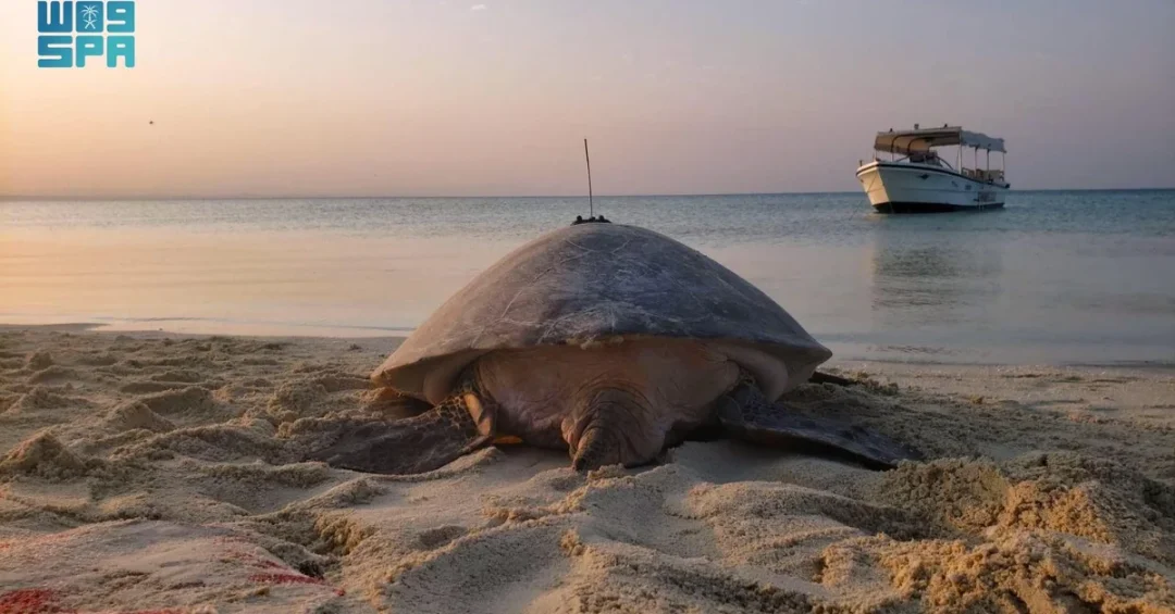
A groundbreaking study from the King Abdullah University of Science and Technology (KAUST) has revealed that satellite tracking of green turtles led to the discovery of 34 previously unknown seagrass meadows in the Red Sea, expanding the known inventory of these vital marine ecosystems by nearly 15%. The research, conducted in collaboration with Queensland’s Department of Environment and Science in Australia and published in the scientific journal Proceedings of the Royal Society B, demonstrates an innovative, low-cost method for mapping underwater habitats that could transform conservation strategies worldwide. The findings were released via official Saudi channels, including the Saudi Press Agency (SPA), underscoring the Kingdom’s growing leadership in marine science and environmental sustainability.
The study tracked 53 green turtles as they foraged across the Red Sea, using their natural movements to identify seagrass meadows that traditional mapping technologies had missed. Seagrass meadows are among the most efficient carbon sinks on the planet, capturing carbon at rates that surpass even tropical rainforests. This discovery not only enhances scientific understanding of the Red Sea’s marine biodiversity but also supports Saudi Arabia’s broader environmental goals under Vision 2030, which seeks to balance economic development with ecological stewardship. How might such nature-inspired solutions redefine the future of marine conservation?
Context and Background
Seagrass meadows are critical marine ecosystems that provide food and shelter for countless species, stabilize coastal sediments, and sequester large amounts of carbon—often referred to as blue carbon. Despite their importance, mapping these underwater habitats has long been a challenge, especially in the Red Sea, where seagrasses can grow at depths of up to 70 meters. Traditional mapping methods, such as the Allen Coral Atlas, rely on satellite imagery that typically penetrates only the top 5 meters of water, leaving vast areas unexamined. This gap in data has hindered effective conservation and climate mitigation efforts.
The KAUST-led study, published in the Proceedings of the Royal Society B, took a novel approach by leveraging the foraging behavior of green turtles. These marine reptiles are known to feed extensively on seagrass, making them natural indicators of meadow locations. By attaching satellite tags to 53 green turtles, researchers were able to follow their journeys and identify 34 new seagrass sites. This method proved almost 20 times more accurate than the Allen Coral Atlas for detecting seagrass in the Red Sea, according to the study. The research highlights how animal behavior can complement advanced technology, offering a cost-effective and scalable solution for ecosystem monitoring.
Carlos Duarte, Professor of Marine Science at KAUST and lead author of the study, emphasized the significance of accurate data for environmental policy. “Technologies like LiDAR and hyperspectral imaging can cost tens of millions of dollars, whereas equipping sea turtles with tracking systems costs less than 1% of these high-tech alternatives,” he said. This affordability makes the approach particularly attractive for developing nations and regions with limited resources. The study also involved collaboration with Queensland’s Department of Environment and Science in Australia, demonstrating international scientific cooperation. Could this model be replicated in other marine environments to uncover hidden blue carbon hotspots?
Key Details of the Discovery
The research team tracked 53 green turtles over several months, recording their diving and foraging patterns via satellite transmitters. Green turtles are herbivorous and prefer seagrass beds, so their movement corridors naturally lead to previously unidentified meadows. The data revealed 34 new seagrass meadows, increasing the total number of known sites in the Red Sea by nearly 15%. This is a substantial gain, given that the Red Sea’s seagrass inventory was considered incomplete. The study’s findings were published in the prestigious journal Proceedings of the Royal Society B, adding peer-reviewed credibility to the method.
One of the most striking findings was the depth at which seagrasses thrive in the Red Sea. Unlike typical mapping limits of less than 5 meters, seagrasses in this region can grow at depths up to 70 meters, far beyond the reach of conventional satellite sensors. This depth advantage explains why the turtle-tracking method outperformed the Allen Coral Atlas by a factor of nearly 20. The turtles, diving to feed, provided direct evidence of seagrass presence at depths that technology alone could not detect. The study thus offers a dual benefit: it fills critical data gaps and demonstrates a low-cost, nature-based monitoring tool.
Carlos Duarte highlighted the economic implications of the discovery. Seagrasses, mangroves, and salt marshes are among the most efficient ecosystems for capturing blue carbon, with an estimated economic value in the tens of billions of dollars. By identifying new seagrass meadows, the study helps quantify the Red Sea’s carbon sequestration potential, which is essential for developing blue carbon programs and sustainability policies. Duarte noted that accurate data is fundamental for effective environmental policies and conservation strategies. The study also informs Red Sea sustainability policies, aiding countries in creating blue carbon initiatives. How could these findings influence global carbon markets and climate finance?
International and Regional Impact
The study’s implications extend beyond Saudi Arabia’s borders. The Red Sea is bordered by multiple countries, including Egypt, Sudan, Eritrea, Djibouti, and Yemen, many of which share similar marine ecosystems. The new seagrass meadows could contribute to regional conservation efforts and transboundary marine protected areas. By providing a cost-effective mapping method, the research empowers these nations to better manage their blue carbon resources, which are increasingly recognized in international climate agreements. The collaboration with Queensland’s Department of Environment and Science in Australia also highlights the global relevance of the findings, as seagrass meadows are declining worldwide.
For Saudi Arabia, the discovery reinforces its position as a leader in marine science and environmental sustainability. KAUST, a premier research institution, continues to produce cutting-edge studies that align with Vision 2030’s environmental goals. The Kingdom has already launched several initiatives to protect its marine environments, including the Saudi Green Initiative and the Red Sea Project, which aims to develop sustainable tourism while preserving ecosystems. This study provides scientific backing for such efforts, offering a blueprint for integrating biodiversity data into policy. Could this turtle-tracking technique become a standard tool for marine spatial planning in the region?
Economic and Strategic Significance
Seagrass meadows are not only ecological treasures but also economic assets. They support fisheries, protect coastlines from erosion, and store carbon that would otherwise contribute to climate change. The economic value of blue carbon ecosystems is estimated in the tens of billions of dollars globally, and the newly discovered meadows in the Red Sea add to this natural capital. For Saudi Arabia, these findings could attract investment in carbon credits and sustainable blue economy projects, aligning with Vision 2030’s aim to diversify revenue streams and promote environmental stewardship.
Strategically, the study enhances the Kingdom’s scientific reputation and soft power. By publishing in a high-impact journal and collaborating with international partners, KAUST demonstrates that Saudi Arabia is at the forefront of innovative research. The low-cost nature of the turtle-tracking method makes it particularly appealing for scaling up across the Red Sea and beyond. As global demand for accurate carbon accounting grows, Saudi Arabia could become a hub for blue carbon research and policy development. How might this discovery shape the Kingdom’s role in international climate negotiations?
Vision 2030 Alignment
The KAUST study directly supports Vision 2030’s environmental sustainability pillar, which seeks to protect natural resources and promote renewable energy and conservation. By uncovering new seagrass meadows, the research aids in quantifying blue carbon stocks, a key component of the Kingdom’s climate strategy. Vision 2030 also emphasizes knowledge-based economic growth, and KAUST’s breakthrough exemplifies how Saudi institutions can lead in science and innovation. The study’s findings will inform Red Sea sustainability policies, ensuring that development projects, such as NEOM and the Red Sea Project, are designed with ecological sensitivity.
Furthermore, the research underscores the importance of international collaboration, a cornerstone of Vision 2030’s foreign policy. Partnering with Queensland’s Department of Environment and Science showcases Saudi Arabia’s commitment to global scientific cooperation. As the Kingdom continues to invest in marine research and blue carbon initiatives, it positions itself as a responsible global citizen and a leader in the fight against climate change. The discovery of 34 new seagrass meadows is more than a scientific milestone; it is a testament to Saudi Arabia’s vision of a sustainable, prosperous future. What other hidden wonders might the Red Sea reveal through such innovative approaches?
20 Questions
Q1. What did the KAUST study discover?
A1. The study discovered 34 new seagrass meadows in the Red Sea by tracking green turtles, increasing the known inventory by nearly 15%.
Q2. Who conducted the research?
A2. The research was led by KAUST in collaboration with Queensland’s Department of Environment and Science in Australia.
Q3. Where was the study published?
A3. It was published in the scientific journal Proceedings of the Royal Society B.
Q4. How many green turtles were tracked?
A4. Scientists tracked 53 green turtles to identify the seagrass meadows.
Q5. Why are seagrass meadows important?
A5. They are vital carbon sinks, support marine life, and have economic value in the tens of billions of dollars.
Q6. What is the Allen Coral Atlas?
A6. It is an online resource mapping benthic habitats, but it is limited to depths of less than 5 meters.
Q7. How much more accurate is turtle tracking compared to the Allen Coral Atlas?
A7. Turtle tracking is almost 20 times more accurate for identifying seagrass meadows in the Red Sea.
Q8. What depths can seagrass grow in the Red Sea?
A8. Seagrass in the Red Sea can grow at depths of up to 70 meters.
Q9. Who is Carlos Duarte?
A9. Carlos Duarte is a Professor of Marine Science at KAUST and the lead author of the study.
Q10. What did Duarte say about the cost of tracking turtles?
A10. He said equipping sea turtles with tracking systems costs less than 1% of high-tech alternatives like LiDAR.
Q11. What are blue carbon ecosystems?
A11. They are seagrasses, mangroves, and salt marshes that capture and store carbon efficiently.
Q12. How do seagrasses compare to rainforests in carbon storage?
A12. Seagrasses outperform rainforests in their carbon storage capabilities.
Q13. Why is mapping seagrass meadows important?
A13. Accurate maps help develop environmental policies, conservation strategies, and blue carbon programs.
Q14. What is the economic value of blue carbon ecosystems?
A14. They have an estimated economic value in the tens of billions of dollars.
Q15. How does this study support Saudi Vision 2030?
A15. It aligns with Vision 2030’s environmental sustainability goals and promotes knowledge-based economic growth.
Q16. What other countries could benefit from this method?
A16. Other Red Sea nations and countries with seagrass ecosystems could use this cost-effective tracking method.
Q17. What technology was used to track the turtles?
A17. Satellite tracking systems were attached to the turtles to monitor their foraging journeys.
Q18. Why is the Red Sea’s seagrass inventory incomplete?
A18. Traditional mapping methods cannot detect seagrass at depths beyond 5 meters, leaving many areas unmapped.
Q19. What are the implications for climate change mitigation?
A19. The discovery enhances blue carbon accounting, which is crucial for climate change mitigation and carbon markets.
Q20. What does the study suggest about future research?
A20. It suggests that combining animal tracking with technology can transform marine ecosystem assessment and conservation globally.
Reader Feedback
We value your thoughts. Please share your feedback on this article.
Your feedback helps us improve our coverage.
Related articles
 Tawakkalna Expands to Over 600 Digital Government Services
 NCVC Launches Wild Plant Survey with King Saud University
 KAUST Lithium Brine Breakthrough Could Make Saudi Arabia a Producer
 Venus and Saturn to Converge in Skies of Saudi Arabia Saturday
 Manga Productions Launches Dynasty Warriors: ORIGINS in Riyadh
 ITU Commends Saudi CST’s Global Digital Regulatory Role