


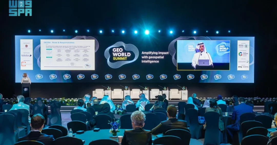
Saudi Arabia’s General Authority for Survey and Geospatial Information (GEOSA) participated in the GeoWorld Summit in Dubai from November 26 to 28, 2024, showcasing the Kingdom’s rapid progress in geospatial infrastructure and its growing leadership in the global geospatial community. The summit, which brought together representatives from more than 20 countries, including technology experts, business leaders, and researchers, served as a platform for GEOSA to present a series of technical papers and host an exhibition pavilion highlighting its recent accomplishments. Is it any wonder that the Kingdom’s geospatial sector is attracting such intense international attention?
According to the Saudi Press Agency (SPA), GEOSA’s delegation was led by Eng. Mohammad Almabrook, Executive Director for International Cooperation and Partnership, who spoke on behalf of GEOSA President Dr. Mohammed Yahya Alsayel. Almabrook outlined GEOSA’s mandate to oversee the geospatial information and surveying sector and emphasized the Kingdom’s efforts to develop a national geospatial infrastructure through projects, policies, legislation, and data governance practices aligned with global standards. The participation underscores Saudi Arabia’s determination to position itself at the forefront of a field that is increasingly central to smart city development, environmental monitoring, and data-driven governance.
Context and Background
Why has geospatial information become such a critical pillar of modern governance? Geospatial data — information tied to specific geographic locations — underpins everything from urban planning and disaster response to navigation services and environmental protection. As economies digitize, the ability to collect, manage, and analyze such data has become a marker of national competitiveness. Saudi Arabia recognized this early, establishing GEOSA to regulate and develop the sector in line with international best practices. The authority’s work is integral to the Kingdom’s broader modernization agenda, which seeks to harness technology for efficient public services and sustainable development.
The GeoWorld Summit, held annually in Dubai, is one of the premier gatherings for the geospatial industry. This year’s edition focused on trends and strategies related to data-driven decision-making, including big data management, real-time data integration, privacy and security, technological adaptation, geospatial analytics, navigation services, remote sensing, and environmental monitoring. Speakers also explored the future of geospatial information, its role in smart cities, and solutions to societal and environmental challenges. By participating actively, Saudi Arabia signals its commitment to shaping these global conversations rather than merely following them.
GEOSA’s presence at the summit is part of a sustained international engagement strategy. Over the past several years, the authority has forged partnerships with counterparts in Asia, Europe, and the Americas, sharing expertise and contributing to the development of global standards. This outward-looking approach reflects a broader Saudi foreign policy that leverages specialized knowledge and technical cooperation as instruments of soft power and diplomatic goodwill. How does such engagement benefit the Kingdom domestically? It brings access to cutting-edge research, fosters investment in local talent, and ensures that Saudi infrastructure projects are built on internationally recognized data frameworks.
Key Details
At the heart of GEOSA’s message in Dubai was the recent approval by the United Nations Committee of Experts on Global Geospatial Information Management (UN-GGIM) for Saudi Arabia to host and establish the UN Global Geospatial Ecosystem Center of Excellence. Almabrook noted the significant steps the Kingdom has already taken to set up the center’s headquarters in Riyadh. This center, once operational, will serve as a hub for research, capacity-building, and international collaboration, further elevating Saudi Arabia’s status in the global geospatial ecosystem. The approval is a testament to the Kingdom’s technical credibility and its active role within UN-GGIM.
GEOSA’s pavilion at the summit exhibition showcased a range of accomplishments, from advanced surveying projects to the integration of geospatial data into national planning. Visitors could learn about the Kingdom’s efforts to build a comprehensive spatial data infrastructure that supports sectors as diverse as transportation, agriculture, energy, and tourism. The authority also presented papers detailing its approach to data governance, privacy, and security — issues of paramount importance as geospatial datasets grow in size and sensitivity. These presentations highlighted how Saudi Arabia is aligning its practices with global standards for integrated geospatial information system usage among relevant organizations.
The summit’s agenda also included discussions on bridging the gap between industry, academia, blockchain technology, and geospatial data. GEOSA’s participation in these sessions allowed its experts to exchange views with peers from around the world, exploring how emerging technologies can enhance the accuracy, accessibility, and utility of geospatial information. Such exchanges are vital for keeping Saudi Arabia’s infrastructure at the technological frontier and for nurturing a domestic ecosystem of innovation. By engaging with blockchain and other disruptive tools, GEOSA is preparing the ground for a future in which geospatial data is not only more precise but also more secure and transparent.
International and Regional Impact
What does Saudi Arabia’s active role in the geospatial arena mean for the wider Middle East? The region is undergoing unprecedented urban and economic transformation, with mega-projects and smart city initiatives demanding robust spatial data. By leading in this field, Saudi Arabia can become a source of expertise and a partner for neighboring countries embarking on similar journeys. The UN Global Geospatial Ecosystem Center of Excellence in Riyadh will likely attract talent and investment from across the region, reinforcing the Kingdom’s position as a knowledge hub. This aligns with the broader trend of Gulf states diversifying their economies and investing in high-value, technology-driven sectors.
Globally, the establishment of the center signals Saudi Arabia’s readiness to contribute to multilateral efforts on sustainable development. Geospatial information is essential for monitoring progress on the UN Sustainable Development Goals, from tracking climate change impacts to mapping poverty and improving food security. By hosting a center of excellence, the Kingdom will help build capacity in developing countries, offering training and technical assistance. This cooperative spirit enhances Saudi Arabia’s international standing and demonstrates its commitment to global public goods — a role that resonates with the Kingdom’s G20 leadership and its active participation in international forums.
Economic and Strategic Significance
How does geospatial infrastructure translate into economic value? Accurate spatial data reduces costs and risks in construction, logistics, and resource management. It enables smarter decisions about land use, infrastructure placement, and environmental protection, saving billions in potential inefficiencies. For Saudi Arabia, where giga-projects like NEOM and the Red Sea Project are reshaping vast areas, geospatial precision is not a luxury but a necessity. GEOSA’s work supports these endeavors by providing the foundational data that planners, engineers, and investors rely on. As the Kingdom pursues economic diversification under Vision 2030, the geospatial sector itself becomes a source of high-skilled jobs and technological innovation.
Strategically, leadership in geospatial information enhances national security and disaster resilience. Real-time data integration and remote sensing allow authorities to respond swiftly to natural disasters, monitor borders, and manage critical infrastructure. The privacy and security discussions at the summit reflect a growing awareness that geospatial data must be safeguarded against misuse. Saudi Arabia’s proactive stance on data governance positions it as a responsible actor in an era of increasing digital interdependence. By investing in these capabilities, the Kingdom strengthens its sovereignty and its ability to protect its citizens and assets.
Vision 2030 Alignment
How does GEOSA’s participation in the GeoWorld Summit connect to Saudi Vision 2030? The Vision, launched in 2016 by Crown Prince Mohammed bin Salman, aims to transform the Kingdom into a diversified, knowledge-based economy. Geospatial information is a cross-cutting enabler of that transformation, supporting sectors from tourism to mining to smart cities. GEOSA’s efforts to build a world-class national geospatial infrastructure directly contribute to Vision 2030 objectives such as enhancing government efficiency, fostering innovation, and improving quality of life. The upcoming UN center in Riyadh will further cement the Kingdom’s role as a global leader in this domain, attracting international collaboration and investment.
As Saudi Arabia continues to expand its geospatial capabilities, its voice in global forums will only grow stronger. The Kingdom’s participation in the Dubai summit is another step in a journey that began with the establishment of GEOSA and will culminate in a fully integrated spatial data ecosystem serving all aspects of national development. By sharing knowledge, hosting international centers, and adhering to global standards, Saudi Arabia is not only advancing its own Vision 2030 but also contributing to a more connected and sustainable world. The future of geospatial information is being written now, and the Kingdom is helping to write it.
20 Questions
Q1. What is the GeoWorld Summit?
A1. The GeoWorld Summit is a global event that gathers geospatial experts, technology leaders, and researchers to discuss advancements in geospatial technology. The 2024 edition was held in Dubai from November 26 to 28.
Q2. Which Saudi authority participated in the summit?
A2. The General Authority for Survey and Geospatial Information (GEOSA) represented Saudi Arabia at the summit, showcasing the Kingdom’s achievements and contributing to discussions on geospatial trends.
Q3. How many countries were represented at the summit?
A3. Representatives from over 20 countries attended the summit, including technology experts, business leaders, and researchers from around the world.
Q4. What did GEOSA present at the event?
A4. GEOSA presented various papers and set up an exhibition pavilion to showcase its recent accomplishments in geospatial infrastructure, highlighting the Kingdom’s efforts to enhance the sector.
Q5. Who spoke on behalf of GEOSA at the summit?
A5. Eng. Mohammad Almabrook, Executive Director for International Cooperation and Partnership, spoke on behalf of GEOSA President Dr. Mohammed Yahya Alsayel.
Q6. What recent UN approval did GEOSA highlight?
A6. GEOSA noted the approval by the UN Committee of Experts on Global Geospatial Information Management for Saudi Arabia to host and establish the UN Global Geospatial Ecosystem Center of Excellence.
Q7. Where will the UN center be headquartered?
A7. The center’s headquarters will be established in Riyadh, Saudi Arabia, as part of the Kingdom’s efforts to lead in geospatial information globally.
Q8. What topics were discussed at the summit?
A8. Discussions covered data-driven decision making, big data management, real-time data integration, privacy and security, geospatial analytics, navigation services, remote sensing, and environmental monitoring.
Q9. How does geospatial information support smart cities?
A9. Geospatial information provides essential data for urban planning, infrastructure development, and service delivery, enabling smart cities to operate efficiently and sustainably.
Q10. What is GEOSA’s role in Saudi Arabia?
A10. GEOSA oversees the geospatial information and surveying sector, developing national infrastructure through projects, policies, legislation, and data governance aligned with global standards.
Q11. Why is Saudi Arabia’s participation significant?
A11. It bolsters the Kingdom’s leading role in geospatial information, demonstrates its commitment to international cooperation, and supports its Vision 2030 goals of economic diversification and innovation.
Q12. What is the UN-GGIM?
A12. The United Nations Committee of Experts on Global Geospatial Information Management (UN-GGIM) is a global body that sets standards and promotes cooperation in geospatial information management.
Q13. How will the center of excellence benefit Saudi Arabia?
A13. It will attract international collaboration, enhance local expertise, and position Riyadh as a global hub for geospatial research and capacity-building.
Q14. What are some applications of geospatial data?
A14. Applications include urban planning, disaster response, environmental monitoring, navigation, agriculture, and infrastructure development, among many others.
Q15. How does geospatial data contribute to Vision 2030?
A15. It supports efficient government, innovation, and quality of life improvements, aligning with Vision 2030’s goals of a diversified, knowledge-based economy.
Q16. What did Almabrook emphasize in his speech?
A16. He emphasized GEOSA’s role in developing national geospatial infrastructure through projects, policies, legislation, and data governance aligned with global standards.
Q17. What is the significance of data governance in geospatial information?
A17. Data governance ensures privacy, security, and quality, which are essential for maintaining trust and enabling effective use of geospatial data across sectors.
Q18. How does the summit address blockchain technology?
A18. The summit explored bridging the gap between industry, academia, blockchain technology, and geospatial data, discussing how blockchain can enhance data security and transparency.
Q19. What future trends in geospatial information were discussed?
A19. Trends included real-time data integration, AI-driven analytics, enhanced remote sensing, and the growing role of geospatial data in addressing societal and environmental challenges.
Q20. What is the expected outcome of Saudi Arabia’s participation?
A20. The participation strengthens Saudi Arabia’s global leadership in geospatial information, fosters partnerships, and advances the Kingdom’s Vision 2030 objectives.
Reader Feedback
We value your thoughts. Please share your feedback on this article.
Your feedback helps us improve our coverage.
Related articles
 Tuwaiq Academy to Hold 150 Technical Bootcamps in 2025
 JEDI, RDIA Announce Plans for Advanced Research Cooperation
 Saudi Arabia Stresses AI’s Vital Role in Scientific Research
 K.A.CARE Completes High Concentration Photovoltaic System
 SDAIA: AI Saves 1.5B Liters of Water in Saudi Arabia
 KAUST Leads Land Reclamation Research to Fight Climate Change