


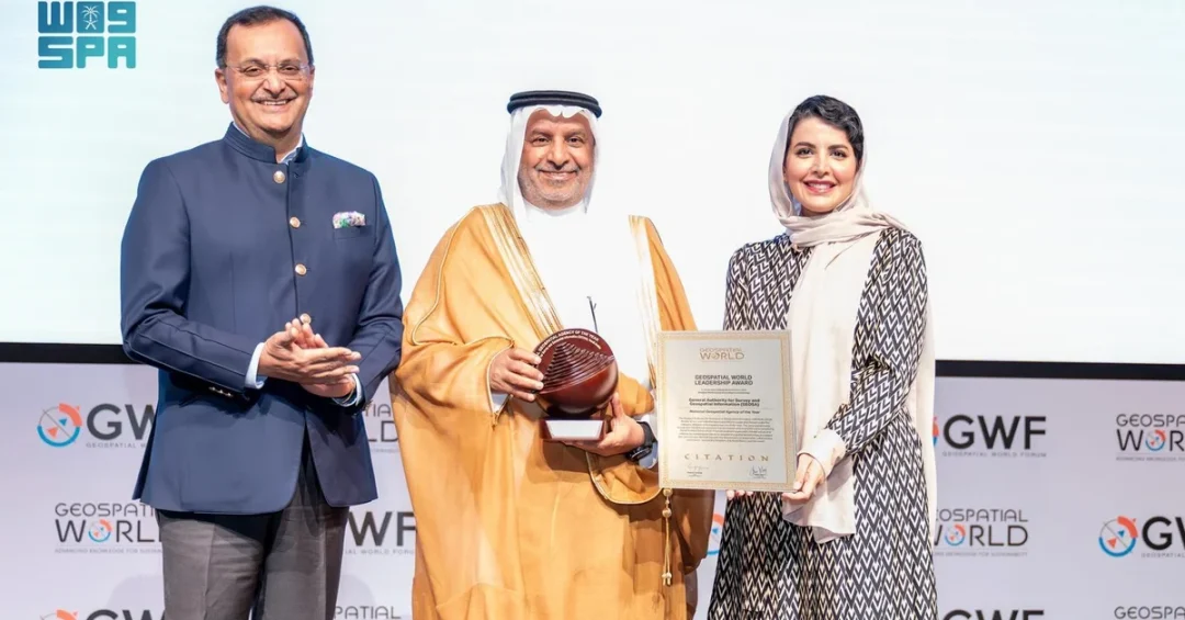
The General Authority for Survey and Geospatial Information (GEOSA) has won the Global Geospatial Leadership Award at the Geospatial World Forum 2025 in Madrid, Spain, recognizing the Kingdom of Saudi Arabia as home to one of the world’s foremost governmental geospatial institutions. The award, announced during the forum held from April 22 to 25, was presented in the presence of Saudi Ambassador to Spain Princess Haifa bint Abdulaziz bin Ayyaf and GEOSA President Dr. Mohammed bin Yahya Al Sayel. The unanimous selection by an international jury of experts underscores the Kingdom’s rapid ascent in geospatial technology and data governance.
How did a national authority founded less than two decades ago come to be celebrated on a global stage alongside the world’s most advanced geospatial agencies? The answer lies in a deliberate national strategy that has positioned geospatial information as a cornerstone of Saudi Arabia’s modernization. Under the unwavering support of Custodian of the Two Holy Mosques King Salman bin Abdulaziz Al Saud and His Royal Highness Prince Mohammed bin Salman bin Abdulaziz Al Saud, Crown Prince and Prime Minister, the sector has received unprecedented backing. This recognition reflects not only GEOSA’s technical achievements but also the Kingdom’s broader commitment to harnessing data for smart decision-making and sustainable development.
Context and Background
What exactly is GEOSA, and why does its work matter to citizens and the global community alike? The General Authority for Survey and Geospatial Information serves as the national regulator for the geospatial sector in Saudi Arabia. It oversees the development of national geospatial infrastructure, sets standards to ensure integrated use of geospatial information among stakeholders, and governs data policies aligned with international best practices. Its mandate extends to advancing research, building national capabilities, and integrating geospatial information with advanced technologies such as artificial intelligence and communication systems. This comprehensive role makes GEOSA a central pillar in the Kingdom’s digital transformation.
The award itself comes from Geospatial World, a leading non-profit platform founded in 1996 that serves the global geospatial community. The organization focuses on raising awareness of geospatial information and its role in addressing societal, environmental, and economic challenges. Since 2007, it has hosted the Geospatial World Leadership Awards, which are chosen by a jury of global experts. Winning this award places GEOSA in the company of the world’s most innovative geospatial agencies. The forum in Madrid brought together thousands of professionals, policymakers, and technology leaders, making the recognition a powerful endorsement of Saudi Arabia’s strategic direction.
What does it mean for a national authority to be recognized as one of the world’s best governmental geospatial institutions? It signals that the Kingdom’s investments in data infrastructure, human capital, and regulatory frameworks are yielding world-class results. GEOSA’s achievement is not an isolated event but the culmination of years of dedicated effort under the guidance of Minister of Defense Prince Khalid bin Salman, Chairman of GEOSA’s Board of Directors. His strategic leadership has ensured that geospatial development aligns with national priorities, including urban planning, environmental management, and economic diversification. This award validates that approach and amplifies Saudi Arabia’s voice in global geospatial governance.
Key Details
How did the award ceremony unfold, and who were the key figures present? The event took place in Madrid, Spain, during the Geospatial World Forum 2025, held from April 22 to 25. Saudi Ambassador to Spain Princess Haifa bint Abdulaziz bin Ayyaf attended the ceremony, highlighting the diplomatic significance of the achievement. GEOSA President Dr. Mohammed bin Yahya Al Sayel accepted the award on behalf of the Kingdom. Their presence underscored the intersection of technical excellence and international diplomacy that defines Saudi Arabia’s global engagement. The unanimous selection by the jury was particularly notable, as it reflected a consensus among experts from diverse backgrounds that GEOSA’s work stands out globally.
What specific aspects of GEOSA’s work impressed the jury? The authority has developed a comprehensive national geospatial infrastructure that supports everything from urban development to disaster response. It has established policies for data governance that ensure accuracy, accessibility, and interoperability. GEOSA has also championed the integration of geospatial information with AI and communication systems, enabling smart decision-making across government and industry. Its efforts in capacity building, including training programs and research initiatives, have created a skilled workforce capable of sustaining innovation. These elements combine to form a model that other nations seek to emulate, demonstrating Saudi Arabia’s leadership in a field critical to modern governance.
How does this recognition reflect the support from the highest levels of Saudi leadership? The award citation explicitly acknowledged the unwavering support of Custodian of the Two Holy Mosques King Salman bin Abdulaziz Al Saud and Crown Prince Mohammed bin Salman. This backing has translated into strategic guidance, resources, and a mandate to excel. Minister of Defense Prince Khalid bin Salman, as Chairman of GEOSA’s Board of Directors, has provided direction that ensures geospatial development serves national goals. Such high-level attention is rare globally and signals that Saudi Arabia views geospatial information as a strategic asset, not merely a technical tool. This political will has been instrumental in GEOSA’s rapid rise to global prominence.
International and Regional Impact
What are the broader implications of this award for Saudi Arabia’s role on the world stage? The recognition positions the Kingdom as a leader in the global geospatial community, opening doors for collaboration, knowledge exchange, and influence in setting international standards. It enhances Saudi Arabia’s soft power, demonstrating that the country is not only a major economy but also a source of technological and governance innovation. For regional neighbors, GEOSA’s success offers a model for how to build robust geospatial ecosystems. The award also strengthens Saudi Arabia’s case for hosting international forums and attracting talent, further integrating the Kingdom into global networks of expertise.
How might this achievement affect the geospatial sector within Saudi Arabia and the wider Middle East? It is likely to spur increased investment in geospatial technologies, as both public and private entities recognize the value of advanced data infrastructure. Young Saudis may be inspired to pursue careers in surveying, geoinformatics, and related fields, contributing to a knowledge-based economy. Regional cooperation could accelerate, with Saudi Arabia sharing best practices and leading joint initiatives. The award also reinforces the Kingdom’s commitment to the Sustainable Development Goals, as geospatial data is essential for monitoring environmental change, managing resources, and planning resilient cities. In this way, the recognition has ripple effects that extend far beyond the ceremony in Madrid.
Economic and Strategic Significance
Why does geospatial information matter economically, and how does GEOSA’s work support Saudi Arabia’s prosperity? Geospatial data underpins countless sectors, from construction and agriculture to transportation and energy. Accurate mapping and spatial analysis enable efficient infrastructure planning, reduce costs, and minimize environmental impact. For a country undergoing rapid transformation like Saudi Arabia, these capabilities are indispensable. GEOSA’s standards ensure that data is reliable and interoperable, which attracts investment and facilitates public-private partnerships. By integrating geospatial information with AI, the Kingdom can optimize logistics, enhance urban mobility, and improve service delivery. The economic value of these applications is immense, and GEOSA’s global recognition signals that Saudi Arabia is a reliable partner in this domain.
What strategic advantages does leadership in geospatial technology confer on the Kingdom? It supports national security, as accurate geospatial intelligence is vital for border management, defense planning, and emergency response. It aids in the management of natural resources, including water and minerals, which are critical to economic diversification. It also enhances the Kingdom’s ability to monitor and mitigate climate change impacts, from desertification to coastal erosion. Furthermore, geospatial leadership aligns with Saudi Arabia’s ambition to be a hub for technology and innovation, attracting international companies and startups. By excelling in this field, the Kingdom strengthens its position as a regional leader and a global player, capable of shaping the future of data-driven governance.
Vision 2030 Alignment
How does GEOSA’s global award connect to Saudi Vision 2030? Vision 2030 aims to diversify the economy, improve quality of life, and build a thriving, modern nation. Geospatial information is a foundational enabler of these goals. It supports smart city development, such as NEOM and other giga-projects, by providing the spatial data needed for design, construction, and operations. It enhances government efficiency through better planning and resource allocation. It also fosters innovation and entrepreneurship, as geospatial data can be used to create new products and services. GEOSA’s recognition thus validates a key component of the Vision 2030 strategy and demonstrates tangible progress toward its objectives.
What does the future hold for Saudi Arabia’s geospatial sector, and how will this award shape it? The recognition is likely to accelerate ongoing initiatives, attract further investment, and deepen international partnerships. GEOSA will continue to advance national infrastructure, integrate emerging technologies, and promote data-driven decision-making across all levels of government and society. The award also serves as a morale boost for the talented professionals working in the sector, reinforcing that their efforts are valued globally. As the Kingdom marches toward 2030, geospatial information will play an increasingly central role in achieving sustainable development, economic resilience, and a high quality of life for all citizens. This award is not just a milestone; it is a catalyst for even greater achievements.
20 Questions
Q1. What award did GEOSA win in Spain?
A1. GEOSA won the Global Geospatial Leadership Award at the Geospatial World Forum 2025 in Madrid, Spain, recognizing it as one of the world’s best governmental geospatial institutions.
Q2. When and where was the award presented?
A2. The award was presented during the Geospatial World Forum 2025, held in Madrid, Spain, from April 22 to 25, 2025.
Q3. Who attended the award ceremony?
A3. Saudi Ambassador to Spain Princess Haifa bint Abdulaziz bin Ayyaf and GEOSA President Dr. Mohammed bin Yahya Al Sayel attended the ceremony.
Q4. What is Geospatial World?
A4. Geospatial World is a leading non-profit platform founded in 1996 that serves the global geospatial community, focusing on raising awareness of geospatial information and its role in addressing societal, environmental, and economic challenges.
Q5. How are the Geospatial World Leadership Awards chosen?
A5. Since 2007, the awards have been chosen by a jury of global experts who evaluate nominees based on their contributions and leadership in the geospatial field.
Q6. Why was GEOSA selected for this award?
A6. GEOSA was unanimously selected for its leadership in developing national geospatial infrastructure, governing data, setting policies aligned with international best practices, and advancing geospatial capabilities and research.
Q7. What support did GEOSA receive from Saudi leadership?
A7. The award reflects the unwavering support of Custodian of the Two Holy Mosques King Salman bin Abdulaziz Al Saud and Crown Prince Mohammed bin Salman, as well as the strategic guidance of Minister of Defense Prince Khalid bin Salman, Chairman of GEOSA’s Board of Directors.
Q8. What is GEOSA’s role in Saudi Arabia?
A8. GEOSA is the national regulator for the geospatial sector, responsible for overseeing the sector, developing infrastructure, and setting standards to ensure integrated use of geospatial information among stakeholders.
Q9. How does GEOSA contribute to smart decision-making?
A9. GEOSA integrates geospatial information with advanced technologies like AI and communication systems, enabling smart decision-making across government and industry for sustainable development.
Q10. What is the significance of this award for Saudi Arabia?
A10. The award highlights the Kingdom’s leadership in geospatial infrastructure and data governance, enhances its global standing, and validates its strategic investments in technology and innovation.
Q11. How does this recognition align with Vision 2030?
A11. It aligns with Vision 2030 by supporting economic diversification, smart city development, government efficiency, and innovation, all of which rely on robust geospatial data infrastructure.
Q12. What are the economic benefits of geospatial information?
A12. Geospatial information enables efficient infrastructure planning, resource management, and logistics optimization, reducing costs and attracting investment, which supports economic growth and diversification.
Q13. How does GEOSA’s work impact regional cooperation?
A13. GEOSA’s success offers a model for other nations, fosters knowledge exchange, and positions Saudi Arabia as a leader in the Middle East’s geospatial community, encouraging joint initiatives.
Q14. What technologies does GEOSA integrate with geospatial data?
A14. GEOSA integrates geospatial data with artificial intelligence, communication systems, and other advanced technologies to enhance analysis, automation, and decision-making capabilities.
Q15. How does GEOSA support national security?
A15. Accurate geospatial intelligence supports border management, defense planning, and emergency response, contributing to the Kingdom’s security and resilience.
Q16. What is the Geospatial World Forum?
A16. The Geospatial World Forum is an annual event organized by Geospatial World, bringing together global professionals, policymakers, and technology leaders to discuss geospatial trends and innovations.
Q17. How many years has Geospatial World been organizing these awards?
A17. Geospatial World has hosted the Geospatial World Leadership Awards since 2007, making it an established and respected recognition in the geospatial community.
Q18. What does the award mean for Saudi youth?
A18. It inspires young Saudis to pursue careers in geospatial fields, contributing to a knowledge-based economy and showcasing opportunities in technology and innovation.
Q19. How does GEOSA ensure data quality and interoperability?
A19. GEOSA sets national standards and policies that ensure geospatial data is accurate, accessible, and interoperable, facilitating its integrated use across sectors and stakeholders.
Q20. What is the future outlook for GEOSA and Saudi geospatial sector?
A20. The award is expected to accelerate initiatives, attract investment, and deepen partnerships, further advancing the Kingdom’s geospatial capabilities in line with Vision 2030.
Reader Feedback
We value your thoughts. Please share your feedback on this article.
Your feedback helps us improve our coverage.
Related articles
 Saudi CHIPATHON Concludes, Advancing Chip Design Talent
 Rain Falls Over Riyadh, More Showers Possible
 Update: International Space Station Celebrates 25 Years of Operation
 Hail Municipality Obtains ISO Certification in Sustainable Event Management
 KACST Showcases Integrated Innovation District at IASP Conference in Beijing
 GEA Chairman: BigTime Creative Shop Wins First Emmy Award in Middle East, Africa, Asia