


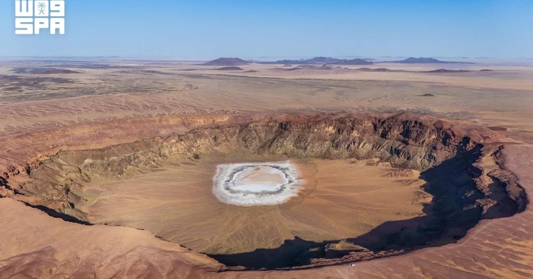
The Al-Haitimah Crater in the Hail region of Saudi Arabia was formed by ancient volcanic activity, which created the area’s geological structure and left dark volcanic rocks from lava flows around it, with subsequent erosion and weathering over thousands of years shaping its current appearance. According to the Saudi百科全书 (Encyclopedia of Saudi Arabia), the crater has a diameter of 1.25 kilometers and a depth of 110 meters, making it a site of significant scientific and natural value due to its diverse geological formations, including volcanic rocks and natural sediments.
Context and Background
The Al-Haitimah Crater is a prominent geological feature in the Hail region, a part of Saudi Arabia known for its rich natural landscapes and historical significance. The region is characterized by volcanic fields that date back millions of years, with the crater being one of the most notable volcanic craters in the Arabian Peninsula. The Saudi Geological Survey has documented numerous volcanic cones and craters across the Kingdom, with Al-Haitimah being a prime example of volcanic activity that shaped the region’s topography.
The crater’s formation is attributed to volcanic eruptions that occurred during the Cenozoic Era, with the resulting lava flows and ash deposits creating the distinctive dark-colored rocks visible today. Over time, natural processes such as wind and water erosion have sculpted the crater, providing scientists with valuable insights into the geological history of the region. The crater also serves as an important site for researchers studying volcanic activity and its impact on the environment.
Key Details
As per the Saudi Encyclopedia, the Al-Haitimah Crater is a caldera-type volcanic crater, with its dimensions making it one of the largest in the region. The crater’s rim offers panoramic views of the nearby Salma Mountains and the surrounding desert landscape, making it a popular destination for nature enthusiasts, photographers, and geologists, particularly during the milder seasons of the year. The site is also part of the Kingdom’s commitment to promoting geotourism, as recognized in Vision 2030’s goal to diversify the economy through tourism development.
The crater is accessible via the Hail region’s network of roads, and the Saudi Commission for Tourism and National Heritage has identified it as a key attraction for both domestic and international visitors. Interpretive signage and visitor facilities are being developed to enhance the experience while preserving the site’s natural integrity. The crater also serves as an outdoor classroom for schools and universities, offering hands-on learning opportunities in geology and environmental science.
Implications
The Al-Haitimah Crater is not only a geological marvel but also a growing contributor to Saudi Arabia’s tourism sector. By attracting nature lovers and researchers, it supports the Kingdom’s Vision 2030 goals of economic diversification and sustainable tourism. The crater has the potential to become a UNESCO Global Geopark candidate, which would further elevate its international profile. Additionally, its preservation aligns with Saudi Arabia’s environmental conservation efforts, showcasing the Kingdom’s commitment to protecting its natural heritage for future generations.
Internationally, the crater offers a unique destination for scientific exchange and collaboration, as researchers from around the world can study its formations to better understand volcanic activity in arid environments. This contributes to global geological knowledge and positions Saudi Arabia as a hub for scientific research and tourism in the Middle East.
Vision 2030 Alignment
The development of the Al-Haitimah Crater as a geotourism destination directly supports Saudi Arabia’s Vision 2030, which seeks to diversify the economy, create job opportunities, and enhance the quality of life for citizens and residents. By promoting unique natural sites like the crater, the Kingdom aims to attract international tourists, boost local economies, and showcase its rich cultural and natural heritage to the world. Furthermore, the preservation and scientific study of such sites align with Vision 2030’s emphasis on environmental sustainability and innovation. As Saudi Arabia continues to develop its tourism infrastructure, the Al-Haitimah Crater stands as a testament to the Kingdom’s commitment to showcasing its natural wonders while building a vibrant and forward-looking society.
20 Questions
Q1. What is the Al-Haitimah Crater?
A1. The Al-Haitimah Crater is a volcanic crater located in the Hail region of Saudi Arabia, formed by ancient volcanic activity. It is about 1.25 kilometers in diameter and 110 meters deep, and it is known for its scientific and natural value.
Q2. How was the Al-Haitimah Crater formed?
A2. The crater was formed by ancient volcanic eruptions, which left dark volcanic rocks and lava flows, and subsequent erosion and weathering over thousands of years shaped its current appearance.
Q3. Where is the Al-Haitimah Crater located?
A3. It is located in the Hail region of Saudi Arabia, which is in the northern part of the country. The area is known for its volcanic landscapes and natural beauty.
Q4. How big is the Al-Haitimah Crater?
A4. According to the Saudi Encyclopedia, the crater has a diameter of about 1.25 kilometers and a depth of 110 meters, making it a notable geological feature in the region.
Q5. Why is the Al-Haitimah Crater important?
A5. The crater is important for its scientific and natural value, as it provides insights into the region’s geological history and volcanic activity. It also attracts tourists and researchers, contributing to the local economy.
Q6. What can visitors see at the Al-Haitimah Crater?
A6. Visitors can see the crater’s volcanic rock formations, panoramic views of the surrounding desert and the Salma Mountains, and diverse geological structures. It is a popular spot for photography and nature walks.
Q7. Is the Al-Haitimah Crater accessible to the public?
A7. Yes, the crater is accessible via local roads, and it is becoming a popular tourist destination. The Saudi Commission for Tourism and National Heritage is working to improve visitor facilities while preserving the site.
Q8. What is the best time to visit the Al-Haitimah Crater?
A8. The best time to visit is during the milder seasons of the year, such as spring and autumn, when temperatures are more comfortable for outdoor activities like hiking and exploring.
Q9. How does the Al-Haitimah Crater contribute to Saudi Arabia’s tourism?
A9. The crater is part of Saudi Arabia’s growing geotourism sector, attracting nature lovers and researchers. It supports the Kingdom’s Vision 2030 goal to diversify the economy and enhance the tourism industry.
Q10. What is geotourism?
A10. Geotourism is a type of tourism that focuses on geological features and landscapes, promoting their preservation and appreciation. The Al-Haitimah Crater is a prime example of a geotourism destination in Saudi Arabia.
Q11. What is the Saudi Encyclopedia’s importance in this context?
A11. The Saudi Encyclopedia is an authoritative source that provides detailed information about the country’s geography and history. It offers factual data about the crater, such as its dimensions, which helps in scientific research and tourism promotion.
Q12. What are the Salma Mountains?
A12. The Salma Mountains are a mountain range near the Al-Haitimah Crater, offering scenic views and adding to the region’s natural beauty. They are often mentioned in descriptions of the crater’s landscape.
Q13. What kind of rocks are found near the crater?
A13. The crater is surrounded by dark volcanic rocks, which are remnants of ancient lava flows. These rocks provide valuable information about past volcanic activity in the area.
Q14. How has erosion affected the crater?
A14. Erosion and weathering over thousands of years have sculpted the crater, shaping its current rim and inner structure. This natural process is still ongoing and contributes to the crater’s dynamic appearance.
Q15. What are the scientific benefits of studying the crater?
A15. Studying the crater helps scientists understand volcanic activity in arid environments, the geological history of the region, and processes like erosion and sediment deposition. It also aids in volcanic hazard assessment.
Q16. Is the crater part of a larger volcanic field?
A16. Yes, the Hail region contains a broader volcanic field with multiple craters and lava formations. The Al-Haitimah Crater is one of the most notable features, but it is part of a larger geological landscape.
Q17. What is the role of the Saudi Geological Survey in managing the crater?
A17. The Saudi Geological Survey is responsible for studying and monitoring geological sites, including the Al-Haitimah Crater. They provide scientific guidance and help protect the site for educational and touristic use.
Q18. Are there any plans to develop the area around the crater?
A18. There are plans to develop tourist facilities, such as interpretive signage and visitor centers, to enhance the experience while ensuring environmental sustainability. These initiatives align with Vision 2030’s tourism development goals.
Q19. How does the crater align with Vision 2030?
A19. The crater supports Vision 2030 by promoting tourism, diversifying the economy, preserving natural heritage, and creating opportunities for sustainable development in the Hail region.
Q20. What is the future outlook for the Al-Haitimah Crater?
A20. The crater is set to become a key attraction in Saudi Arabia’s tourism portfolio, with increasing international interest. It also offers long-term opportunities for scientific research and environmental education, contributing to the Kingdom’s global reputation as a destination for nature and geology.
Reader Feedback
We value your thoughts. Please share your feedback on this article.
Your feedback helps us improve our coverage.