


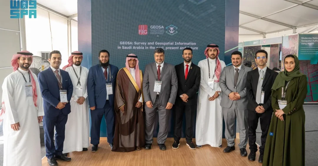
Saudi Arabia’s General Authority for Survey and Geospatial Information (GEOSA) is participating in the annual conference of the International Federation of Surveyors (FIG) in Accra, Ghana, from May 19 to 24, 2024. The conference, themed around geospatial technologies and sustainable natural resource management, has attracted 1,500 participants from 80 countries and features around 70 sessions.
Context and Background
The FIG conference is a major global gathering for surveying and spatial professionals, offering a platform to exchange expertise and share best practices. GEOSA’s participation underscores Saudi Arabia’s growing role in the field of geospatial information, aligning with the Kingdom’s Vision 2030 goals of technological advancement and international cooperation.
Key Details
GEOSA is the platinum sponsor of the conference and held a session titled “Survey and Geospatial Information in Saudi Arabia in the Past, Present, and Future.” The session was attended by FIG President Dr. Diane Dumashie and other experts. Saudi Ambassador to Ghana and Togo Sultan Al-Dakhil visited GEOSA’s pavilion and commended its efforts to strengthen partnerships with international organizations.
Implications and Impact
Saudi Arabia’s active participation in the FIG conference highlights its commitment to global collaboration in geospatial sciences. This engagement facilitates knowledge exchange and positions the Kingdom as a leader in the field, potentially leading to new partnerships and technological advancements that can benefit both Saudi Arabia and the international community.
Vision 2030 Alignment
This participation directly supports Saudi Arabia’s Vision 2030 by fostering innovation, building international partnerships, and enhancing the Kingdom’s reputation as a hub for technology and sustainable development. Through such engagements, Saudi Arabia continues to contribute to global efforts in environmental sustainability and resource management, aligning with its long-term strategic goals.
20 Questions
Q1. What is the International Federation of Surveyors (FIG)?
A1. FIG is a United Nations and World Bank-recognized non-governmental organization, founded in 1878, representing national member associations, mapping agencies, universities, and corporations from over 120 countries.
Q2. Where and when is the FIG annual conference being held in 2024?
A2. The conference is taking place in Accra, Ghana, from May 19 to 24, 2024, under the theme of geospatial technologies and sustainable resource management.
Q3. How many participants are attending the FIG conference?
A3. Around 1,500 participants from 80 countries are attending the conference, which includes about 70 sessions over the week-long event.
Q4. What is the focus of the FIG conference sessions?
A4. The sessions focus on geospatial technologies and innovations that are key tools for ensuring resilient environments and sustainable natural resource management.
Q5. What is the role of GEOSA in the conference?
A5. GEOSA, the General Authority for Survey and Geospatial Information of Saudi Arabia, is the platinum sponsor and conducted a session on the history and future of survey technology in the Kingdom.
Q6. Who attended the GEOSA session titled “Survey and Geospatial Information in Saudi Arabia”?
A6. The session was attended by FIG President Dr. Diane Dumashie and several other experts in the field of surveying and geospatial information.
Q7. What did the Saudi Ambassador to Ghana and Togo do at the conference?
A7. Ambassador Sultan Al-Dakhil visited GEOSA’s pavilion, lauding the authority’s efforts to enhance partnerships with international organizations, reflecting Saudi Arabia’s pioneering role.
Q8. Since when has FIG been established?
A8. FIG was established in 1878, making it one of the oldest international organizations for the surveying profession.
Q9. Which international organizations recognize FIG?
A9. FIG is recognized by the United Nations and the World Bank as a non-governmental organization representing surveying interests globally.
Q10. How many countries are members of FIG?
A10. FIG comprises members from over 120 countries, including national associations, government agencies, universities, and corporations.
Q11. What does the acronym GEOSA stand for?
A11. GEOSA stands for the General Authority for Survey and Geospatial Information, the Saudi government entity responsible for geospatial data and surveying.
Q12. Why is the FIG conference important for Saudi Arabia?
A12. The conference offers Saudi Arabia a platform to showcase its geospatial advancements, learn from global experts, and forge partnerships that support Vision 2030’s innovation goals.
Q13. How does GEOSA’s participation align with Vision 2030?
A13. It aligns by promoting technological advancement, international collaboration, and sustainable development, all key pillars of Saudi Arabia’s Vision 2030 initiative.
Q14. What is the theme of the 2024 FIG conference?
A14. The conference focuses on geospatial technologies and innovations for resilient environments and sustainable natural resource management, reflecting global environmental challenges.
Q15. What kind of session did GEOSA hold?
A15. GEOSA held a session titled “Survey and Geospatial Information in Saudi Arabia in the Past, Present, and Future,” providing a comprehensive look at the field’s evolution.
Q16. Who is Dr. Diane Dumashie?
A16. Dr. Diane Dumashie is the President of the International Federation of Surveyors (FIG), who attended GEOSA’s session, highlighting the significance of Saudi’s contribution.
Q17. What is the role of geospatial technology in sustainable development?
A17. Geospatial technology enables precise mapping and data analysis, crucial for managing natural resources, urban planning, and environmental monitoring, thus supporting sustainability efforts.
Q18. How does GEOSA’s sponsorship benefit the conference?
A18. As platinum sponsor, GEOSA provides financial support and elevates Saudi Arabia’s profile in the global surveying community, demonstrating leadership in the field.
Q19. What is the significance of the Saudi Ambassador’s visit?
A19. The ambassador’s visit underscores the diplomatic importance of geospatial collaboration and strengthens ties with international organizations, reflecting Saudi Arabia’s proactive foreign policy.
Q20. What are the potential outcomes of Saudi Arabia’s participation?
A20. Outcomes may include enhanced knowledge exchange, new partnerships, and increased international recognition of Saudi expertise, contributing to global geospatial advancements and Vision 2030.
Reader Feedback
We value your thoughts. Please share your feedback on this article.
Your feedback helps us improve our coverage.