


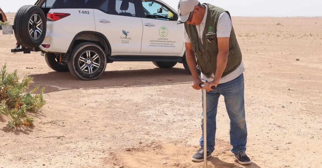
The National Center for Vegetation Development and Combating Desertification (NCVC) has completed the first phase of a comprehensive project to assess land degradation across the Kingdom of Saudi Arabia, producing 246 detailed maps that chart desertification trends and guide future strategies. The milestone, announced via the Saudi Press Agency on May 21, 2024, marks a significant step in Saudi Arabia’s efforts to combat desertification and align with environmental sustainability goals.
Context and Background
Desertification poses a major environmental challenge globally, and the Kingdom is no exception. The NCVC’s project is part of broader national initiatives under Vision 2030 to protect natural resources and promote sustainable land management. The completion of this first phase builds on years of research and data collection, providing a scientific foundation for targeted interventions.
The project involved extensive field surveys, research, and studies conducted by NCVC teams across various regions. By integrating Geographic Information Systems (GIS), remote sensing technologies, and traditional fieldwork, the center gathered comprehensive data on soil conditions, vegetation cover, and land use patterns.
Key Details
The 246 maps produced in this phase provide a detailed understanding of desertification hotspots and the current state of land degradation. Field activities included collecting soil samples for laboratory analysis, studying plant life at designated sites, and analyzing satellite imagery to monitor land cover changes over time. This data is crucial for identifying the causes and types of degradation, which range from climate factors to human activities.
The NCVC has already launched the second phase of the project, beginning in the Riyadh Region. This next stage focuses on pinpointing areas most vulnerable to desertification, classifying the causes and types of land degradation more precisely, and conducting further field surveys to enrich the dataset. The iterative approach ensures that strategies are based on the most accurate and up-to-date information.
Implications and Impact
The completion of this assessment phase has significant implications for Saudi Arabia’s environmental resilience and regional leadership. With detailed maps, the Kingdom can implement targeted measures to restore degraded lands, protect vegetation cover, and improve water management. These actions contribute to the global fight against desertification and support international agreements such as the United Nations Convention to Combat Desertification (UNCCD).
Moreover, the project exemplifies Saudi Arabia’s commitment to using cutting-edge technology in environmental monitoring. The integration of GIS and remote sensing sets a benchmark for other nations in the region, showcasing the Kingdom’s capacity for innovation. The data-driven approach also facilitates knowledge sharing and collaboration with neighboring countries facing similar challenges.
Vision 2030 Alignment
This initiative is a cornerstone of Saudi Arabia’s environmental sustainability efforts under Vision 2030, which aims to increase vegetation cover, enhance biodiversity, and combat desertification. By completing the first phase of this project, the Kingdom moves closer to its targets of reducing land degradation and achieving a green transformation. The NCVC’s work underscores Saudi Arabia’s dedication to preserving its natural heritage for future generations and contributing to global environmental goals.
20 Questions
Q1. What did the National Center for Vegetation Development and Combating Desertification (NCVC) achieve?
A1. The NCVC completed the first phase of a project assessing land degradation across Saudi Arabia, producing 246 detailed maps that chart desertification trends and provide a scientific basis for combatting desertification.
Q2. How were the maps created?
A2. The maps were created using Geographic Information Systems (GIS), remote sensing techniques, and traditional field surveys, including soil sampling, plant studies, and satellite imagery analysis.
Q3. Why is this project important for Saudi Arabia?
A3. This project is vital for identifying desertification hotspots, understanding land degradation causes, and implementing targeted strategies to preserve natural resources, aligning with Vision 2030 sustainability goals.
Q4. When was the completion announced?
A4. The completion was announced on May 21, 2024, via the Saudi Press Agency, marking a significant milestone in the Kingdom’s environmental monitoring efforts.
Q5. What does the second phase of the project involve?
A5. The second phase focuses on identifying areas most vulnerable to desertification, classifying causes and types of land degradation, and conducting further field surveys, starting in the Riyadh Region.
Q6. How does this project contribute to global efforts?
A6. By providing detailed data on desertification, the project supports international initiatives such as the United Nations Convention to Combat Desertification and sets an example for regional environmental monitoring.
Q7. What technologies were used in the project?
A7. The project employed Geographic Information Systems (GIS), remote sensing techniques, and traditional fieldwork methods such as soil sampling and plant surveys.
Q8. What are the expected outcomes of this assessment?
A8. The assessment provides a clear picture of land degradation levels, helping authorities prioritize restoration efforts, improve vegetation cover, and enhance water management.
Q9. Who is responsible for this project?
A9. The National Center for Vegetation Development and Combating Desertification (NCVC) is responsible, operating under the Saudi Ministry of Environment, Water and Agriculture.
Q10. How does this relate to Vision 2030?
A10. The project is part of Vision 2030’s environmental goals to increase vegetation, combat desertification, and ensure sustainable land use, contributing to a greener future for Saudi Arabia.
Q11. What kind of data was collected?
A11. Data included soil samples, plant life studies, and satellite imagery, providing comprehensive information on land conditions, degradation types, and desertification trends.
Q12. How will the maps be used?
A12. The maps will guide decision-making for land rehabilitation, help in identifying priority areas, and inform policies to prevent further land degradation.
Q13. What is the significance of 246 maps?
A13. The large number of maps indicates the project’s extensive coverage, offering a detailed, region-by-region understanding of desertification, essential for targeted actions.
Q14. Does this project involve international cooperation?
A14. While the project is domestically focused, its outcomes can be shared internationally, fostering cooperation on desertification and aligning with global sustainability frameworks.
Q15. How does remote sensing help in this context?
A15. Remote sensing allows for large-scale monitoring of land cover changes over time, identifying trends in desertification without needing extensive on-site surveys, making the process efficient.
Q16. What are desertification hotspots?
A16. Hotspots are areas particularly vulnerable to desertification, where degradation is severe or rapidly worsening. Identifying them helps prioritize interventions.
Q17. How did field surveys complement technology?
A17. Field surveys provided ground-truthing data, verifying satellite imagery, and collecting samples for analysis, ensuring the accuracy of the maps and insights.
Q18. What are the implications for agriculture?
A18. By identifying degraded lands, the project helps in planning sustainable agricultural practices, improving soil health, and ensuring food security in affected regions.
Q19. What is the role of the Riyaadh Region in phase two?
A19. The Riyadh Region serves as the starting point for the second phase, testing methodologies for hotspot identification and detailed classification before expanding nationally.
Q20. When will the full assessment be completed?
A20. The project is ongoing, with phases continuing. The second phase has begun, and subsequent phases will cover other regions, ultimately providing a nationwide assessment.
Reader Feedback
We value your thoughts. Please share your feedback on this article.
Your feedback helps us improve our coverage.