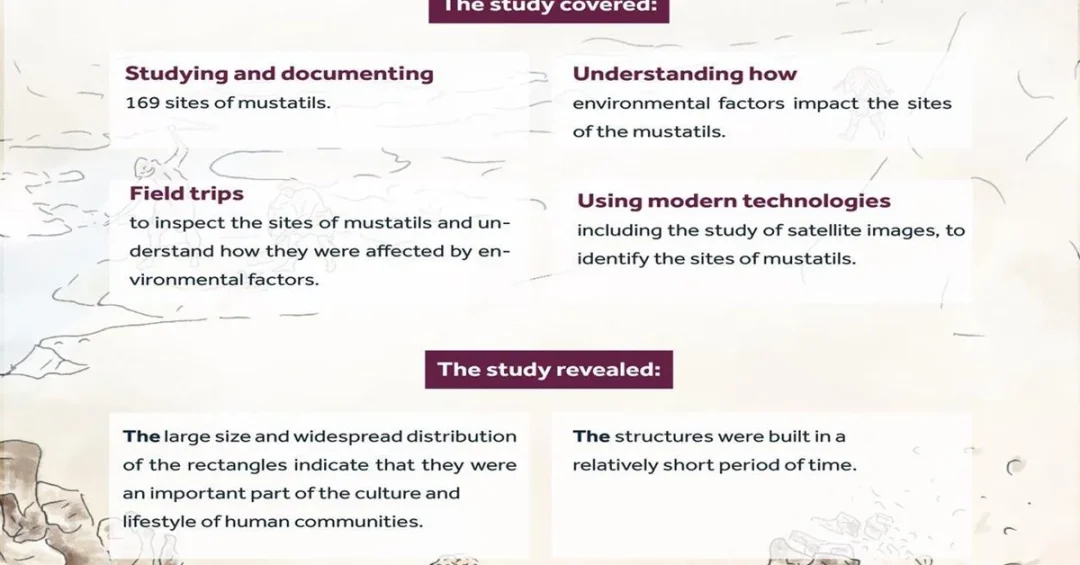
The Saudi Heritage Commission has published a groundbreaking scientific study on the stone rectangles, known as mustatils, in the Hail Region, revealing the deliberate settlement choices of Neolithic inhabitants in northwestern Arabia. The study, featured in the journal The Holocene, is part of the Green Arabia Project, which aims to trace human expansion and migration in the Arabian Peninsula during prehistoric times. Based on precise spatial analysis from archaeological surveys and excavations conducted in 2021, the research sheds new light on ancient life.
Context and Background
The Heritage Commission collaborated with a consortium of leading international and local institutions, including the Max Planck Institute for the Science of Human History in Germany, the University of Tübingen, the University of Cologne, King’s College London, King Abdullah University of Science and Technology, King Saud University, Griffith University in Australia, the University of Queensland, the Smithsonian Institution in the US, and the University of Malta. This extensive partnership underscores Saudi Arabia’s commitment to advancing archaeological research through global scientific cooperation, aligned with the goals of Vision 2030 to preserve and promote the Kingdom’s rich cultural heritage.
Key Details
The stone rectangles are massive archaeological structures dating back to between 5400 and 4200 BC. Located at the periphery of the Nafud Desert, atop hilltops at elevations ranging from 880 to 950 meters, they offer expansive views of the surrounding landscapes, indicating that site selection was not random. Proximity to water sources and raw materials further confirms deliberate choices.
The study reveals significant scattered clusters of these rectangles, suggesting specific patterns of movement and migration among the peoples of that era. It also indicates that the size and distribution of the structures imply multifunctional use, including religious rituals, social practices, and markers of territorial ownership.
Implications and Impact
Experimental studies demonstrated that constructing these stone rectangles was not overly difficult. A small group could build a rectangle 177 meters long in a few weeks, while larger ones may have taken months, but community collaboration accelerated the process. These findings provide insight into the organizational skills and cooperation prevalent in Neolithic societies. The commission stated that applying this type of spatial analysis could lead to the documentation of other stone structures, contributing to a deeper understanding of the organization and establishment of Neolithic communities in northwestern Saudi Arabia.
Vision 2030 Alignment
This study highlights Saudi Arabia’s dedication to uncovering its rich history as a cradle of human civilization, directly supporting Vision 2030’s cultural and tourism objectives. By investing in archaeological research and global partnerships, the Kingdom is positioning itself as a leading destination for heritage tourism and academic excellence, fostering a deeper appreciation for its ancient past and its role in human history.
20 Questions
Q1. What is the Heritage Commission’s recent study about?
A1. The study, published in The Holocene, reveals scientific insights into the stone rectangles (mustatils) in Hail, explaining how Neolithic inhabitants selected settlement locations based on spatial analysis.
Q2. What is the Green Arabia Project?
A2. The Green Arabia Project is a research initiative focused on studying the history of human expansion and migration in the Arabian Peninsula during prehistoric times.
Q3. When was the archaeological research for this study conducted?
A3. The research relied on archaeological surveys and excavations conducted in 2021 at the study sites in the Hail Region.
Q4. What are stone mustatils?
A4. Stone mustatils are massive archaeological structures dating back to between 5400 and 4200 BC, shaped as rectangles, found in northwestern Arabia.
Q5. Where are these stone rectangles located?
A5. They are located at the periphery of the Nafud Desert, atop hilltops with elevations between 880 and 950 meters.
Q6. Why were the locations of the rectangles chosen deliberately?
A6. The locations were chosen for their wide views of surrounding landscapes and proximity to water sources and raw materials.
Q7. What does the study reveal about movement patterns?
A7. The study reveals significant scattered clusters of rectangles, suggesting specific patterns of movement and migration among Neolithic peoples.
Q8. What purposes did the rectangles serve?
A8. The rectangles were likely used for religious rituals, social practices, and as markers of territorial ownership.
Q9. How long did it take to build a stone rectangle?
A9. A small group could build a rectangle 177 meters long in a few weeks, while larger rectangles may have taken months.
Q10. What skills did the builders demonstrate?
A10. The construction showcases organizational skills and cooperation within Neolithic societies.
Q11. Which local institutions collaborated on the study?
A11. Local collaborators include King Abdullah University of Science and Technology and King Saud University.
Q12. Which international institutions participated?
A12. Participants include the Max Planck Institute, University of Tübingen, University of Cologne, King’s College London, Griffith University, University of Queensland, Smithsonian Institution, and University of Malta.
Q13. What journal published the study?
A13. The study was published in The Holocene, a scientific journal focusing on environmental and archaeological research.
Q14. How does this study support Vision 2030?
A14. It aligns with Vision 2030 by preserving cultural heritage, promoting tourism, and fostering global scientific partnerships.
Q15. Can the spatial analysis method be used elsewhere?
A15. Yes, the commission says applying this method could help document other stone structures across Saudi Arabia.
Q16. What does the study say about Neolithic communities?
A16. It provides deeper understanding of the organization and establishment of Neolithic communities in northwestern Saudi Arabia.
Q17. How old are the stone rectangles?
A17. The stone rectangles date back to between 5400 and 4200 BC, making them over 6,000 years old.
Q18. What is the elevation range of the hilltops where rectangles are found?
A18. The hilltops have elevations ranging from 880 to 950 meters.
Q19. Who is responsible for conducting the study?
A19. The Heritage Commission led the study in cooperation with multiple local and international research institutions.
Q20. What is the significance of the Nafud Desert location?
A20. The Nafud Desert periphery provided a strategic setting for settlements, with access to resources and visibility across the landscape.
Reader Feedback
We value your thoughts. Please share your feedback on this article.
Your feedback helps us improve our coverage.