


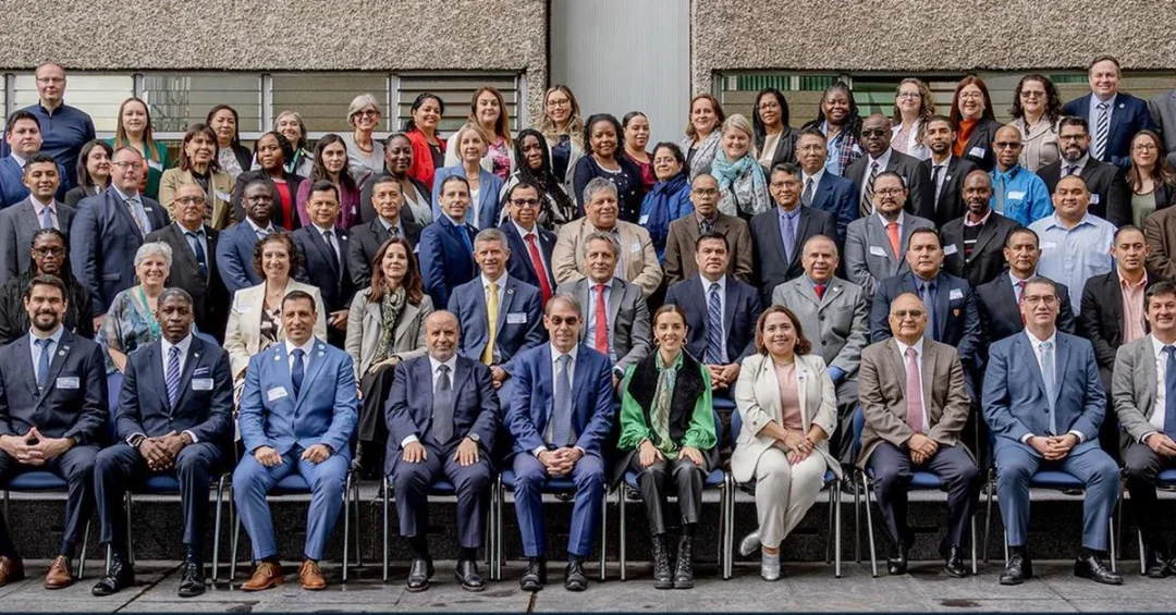
Riyadh – In a significant demonstration of Saudi Arabia’s growing leadership in global geospatial information management, the General Authority for Survey and Geospatial Information (GEOSA) participated in the 7th High-Level Forum on Global Geospatial Information Management, hosted by the United Nations in Mexico from October 8 to 10, 2024. The forum, chaired by the Kingdom, brought together high-level representatives from around the world to discuss the future of geospatial data and its role in sustainable development.
How did Saudi Arabia come to chair such a pivotal UN forum? The answer lies in the Kingdom’s sustained investment in geospatial technologies and its active role in international cooperation, which has positioned it as a trusted leader in this rapidly evolving field. During the event, Dr. Mohammed bin Yahya Al-Sayel, Chair of the Arab Committee of United Nations Experts on Geospatial Information Management (UN-GGIM), presented a comprehensive summary of the committee’s initiatives and achievements. His address underscored the committee’s contributions to global geospatial initiatives through collaboration with UN-GGIM working groups.
Context and Background
What is the significance of the 7th High-Level Forum on Global Geospatial Information Management? Held in Mexico from October 8 to 10, the forum is a premier event that convenes experts, policymakers, and stakeholders to advance the global geospatial agenda. This year’s forum was particularly notable as it was chaired by Saudi Arabia, reflecting the Kingdom’s expanding influence in the field. The event provided a platform for sharing best practices, forging partnerships, and charting the future of geospatial information management.
The Arab Committee of UN-GGIM, which Dr. Al-Sayel chairs, plays a crucial role in coordinating geospatial activities across the Arab region. Under his leadership, the committee has launched several initiatives aimed at harnessing geospatial data for sustainable development. These efforts align with the United Nations’ Integrated Geospatial Information Framework (IGIF), which provides a strategic guide for countries to strengthen their geospatial information management capacities.
Saudi Arabia’s active participation in the forum is part of its broader strategy to position itself as a hub for geospatial innovation. The Kingdom has been investing heavily in survey and geospatial infrastructure, recognizing the critical role such data plays in urban planning, resource management, disaster response, and economic diversification. GEOSA, established in 2019, is at the forefront of these efforts, working to integrate geospatial information into national development plans.
Key Details
What were the key highlights of Saudi Arabia’s participation? Dr. Al-Sayel delivered a keynote address in which he highlighted the Arab Committee’s achievements and its collaboration with UN-GGIM working groups. He also chaired a session titled “The Future of the Incubator Environment for Geospatial Information,” where he emphasized the critical role geospatial information plays in supporting national development goals and improving services. The session explored how incubator environments can foster innovation and entrepreneurship in the geospatial sector.
A major milestone discussed at the forum was the unanimous UN approval to establish and host the Global Center for the Incubator Environment for Geospatial Information in Riyadh. This center, a first of its kind, will serve as a global hub for developing and testing innovative geospatial solutions. Dr. Al-Sayel noted that Saudi Arabia’s contribution to launching the geospatial information incubator project under GEOSA has set a global example with this innovative approach. The project aims to support startups and researchers in developing geospatial applications that address real-world challenges.
GEOSA’s participation also involved bilateral meetings with other delegations to explore avenues for cooperation. The authority reaffirmed its commitment to collaborating with international counterparts to organize and improve the geospatial sector in Saudi Arabia, ensuring improved performance and quality of services. These efforts are expected to enhance the Kingdom’s geospatial capabilities and contribute to the global knowledge base.
International and Regional Impact
How does Saudi Arabia’s leadership in geospatial information management impact the region and the world? By chairing the forum and hosting the Global Center, the Kingdom is bridging regional and global efforts in geospatial data management. The Arab Committee, under Saudi leadership, has become a model for regional cooperation, facilitating the exchange of expertise and resources among Arab states. This collaboration is essential for addressing shared challenges such as climate change, urbanization, and natural resource management.
Globally, the establishment of the Global Center in Riyadh signals a shift in the geospatial landscape, with Saudi Arabia emerging as a key player. The center will attract talent and investment from around the world, fostering innovation and creating new opportunities for collaboration. It will also support the UN’s efforts to implement the IGIF, particularly in developing countries that may lack the resources to build robust geospatial infrastructures. Saudi Arabia’s willingness to share its expertise and host such a center demonstrates its commitment to global partnership and sustainable development.
Economic and Strategic Significance
Why does geospatial information matter for Saudi Arabia’s economy? Geospatial data is a critical asset for economic planning and development. It enables informed decision-making in sectors such as construction, agriculture, transportation, and energy. For Saudi Arabia, which is undergoing a massive economic transformation under Vision 2030, geospatial information is indispensable for projects like NEOM, the Red Sea Project, and Qiddiya. Accurate spatial data helps in site selection, infrastructure planning, and environmental monitoring, ensuring that these mega-projects are sustainable and efficient.
Moreover, the geospatial sector itself is a source of economic growth. The incubator environment and the Global Center will nurture startups and small businesses that specialize in geospatial technologies, creating jobs and driving innovation. This aligns with Vision 2030’s goal of diversifying the economy and fostering a knowledge-based society. By investing in geospatial infrastructure and hosting international centers, Saudi Arabia is not only improving its own capabilities but also positioning itself as a leader in the global geospatial economy.
Vision 2030 Alignment
How does this achievement align with Vision 2030? Saudi Arabia’s Vision 2030 is a comprehensive plan to transform the Kingdom into a diversified, innovative, and globally engaged economy. The geospatial sector is a key enabler of this vision, providing the data and tools needed for smart city development, efficient governance, and sustainable resource management. GEOSA’s participation in the UN forum and the establishment of the Global Center in Riyadh are direct manifestations of the vision’s emphasis on international cooperation and leadership.
Furthermore, the Kingdom’s role in advancing geospatial information management supports several Vision 2030 objectives, including enhancing government effectiveness, boosting private sector growth, and improving quality of life. By leveraging geospatial data, Saudi Arabia can better plan its cities, manage its natural resources, and respond to emergencies. The recognition from the UN and the global community underscores the Kingdom’s progress and its potential to shape the future of geospatial information management worldwide. As Saudi Arabia continues to lead in this field, it reinforces its position as a global hub for innovation and a catalyst for sustainable development.
20 Questions
Q1. What event did GEOSA participate in recently?
A1. GEOSA participated in the 7th High-Level Forum on Global Geospatial Information Management, hosted by the UN in Mexico from October 8 to 10, 2024.
Q2. Who chaired the forum?
A2. Saudi Arabia chaired the forum, reflecting its leadership in geospatial information management.
Q3. Who is Dr. Mohammed bin Yahya Al-Sayel?
A3. He is the Chair of the Arab Committee of United Nations Experts on Geospatial Information Management (UN-GGIM).
Q4. What did Dr. Al-Sayel present at the forum?
A4. He presented a summary of the Arab Committee’s initiatives and achievements, emphasizing its contributions to global geospatial initiatives.
Q5. What session did Dr. Al-Sayel chair?
A5. He chaired the session titled “The Future of the Incubator Environment for Geospatial Information.”
Q6. What is the significance of the incubator environment for geospatial information?
A6. It fosters innovation and entrepreneurship, supporting the development of geospatial solutions for national development goals.
Q7. What global center will be hosted in Riyadh?
A7. The Global Center for the Incubator Environment for Geospatial Information will be hosted in Riyadh, as unanimously approved by the UN.
Q8. What does the Global Center aim to achieve?
A8. It will serve as a hub for developing and testing innovative geospatial solutions, attracting global talent and investment.
Q9. How does Saudi Arabia’s participation benefit the Kingdom?
A9. It enhances Saudi Arabia’s geospatial capabilities, promotes international collaboration, and supports Vision 2030 goals.
Q10. What role does GEOSA play in Saudi Arabia?
A10. GEOSA is responsible for survey and geospatial information, integrating it into national development plans and improving services.
Q11. What is the Arab Committee’s role?
A11. It coordinates geospatial activities across the Arab region and collaborates with UN-GGIM working groups.
Q12. How does geospatial information support national development?
A12. It aids in urban planning, resource management, disaster response, and economic diversification, among other areas.
Q13. What is the UN-GGIM?
A13. The United Nations Committee of Experts on Global Geospatial Information Management, which sets global standards and policies.
Q14. What is the Integrated Geospatial Information Framework (IGIF)?
A14. It is a UN strategic guide for countries to strengthen their geospatial information management capacities.
Q15. How does the Global Center benefit developing countries?
A15. It provides resources and expertise to help them build robust geospatial infrastructures and implement the IGIF.
Q16. What economic benefits does the geospatial sector offer?
A16. It drives innovation, creates jobs, and supports economic diversification, aligning with Vision 2030.
Q17. How does geospatial data support mega-projects like NEOM?
A17. It enables site selection, infrastructure planning, and environmental monitoring, ensuring sustainability and efficiency.
Q18. What is Saudi Arabia’s Vision 2030?
A18. A comprehensive plan to transform Saudi Arabia into a diversified, innovative, and globally engaged economy.
Q19. How does the forum reflect Saudi Arabia’s global role?
A19. It showcases the Kingdom’s leadership in geospatial information management and its commitment to international cooperation.
Q20. What future steps will GEOSA take?
A20. GEOSA will continue to collaborate internationally to improve the geospatial sector in Saudi Arabia and ensure high-quality services.
Reader Feedback
We value your thoughts. Please share your feedback on this article.
Your feedback helps us improve our coverage.
Related articles
 Gulf Scientific Olympiad Kicks Off in Madinah
 King Salman Reserve: A Sanctuary for 26 Endangered Birds
 SAMI-AEC to Showcase AI and Smart Tech at GITEX 2024
 Riyadh to Host Inaugural AI & Drone Exhibition
 Tarshid Completes Energy Efficiency Project at Tabuk University, Saving 24% Consumption
 Moon-Jupiter Conjunction to Light Up Arab Skies Tonight