


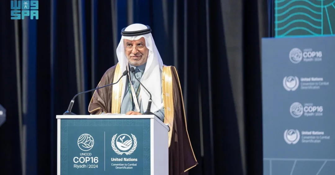
The Saudi General Authority for Survey and Geospatial Information (GEOSA) has officially joined the Group on Earth Observations (GEO), positioning the Kingdom of Saudi Arabia at the center of global efforts to harness geospatial data for environmental sustainability. The announcement, released via the Saudi Press Agency (SPA) on December 12, 2024, coincided with the 16th session of the Conference of the Parties (COP16) of the United Nations Convention to Combat Desertification (UNCCD), held in Riyadh from December 2 to 13. GEOSA will represent Saudi Arabia in organizing the survey, geospatial information, and imaging sector, marking a significant step in the Kingdom’s expanding role in Earth observation and environmental intelligence.
This development underscores Saudi Arabia’s commitment to leveraging advanced technology and international collaboration to address pressing environmental challenges. By joining GEO, GEOSA aims to enhance the role of geospatial information in creating smart solutions that integrate science and emerging technologies for a sustainable environment. The move aligns with the Kingdom’s broader Vision 2030 objectives, which prioritize environmental sustainability, technological innovation, and global partnerships. As the world grapples with climate change and land degradation, Saudi Arabia’s proactive engagement in Earth observation signals its determination to contribute meaningfully to global environmental governance.
Context and Background
What drives a nation to invest in the intricate science of Earth observation? For Saudi Arabia, the answer lies in its unique geographical and environmental context. The Kingdom encompasses vast deserts, fragile ecosystems, and rapidly urbanizing regions, all of which require precise monitoring and management. GEOSA, established to oversee survey and geospatial information, has been instrumental in mapping the Kingdom’s resources and supporting development projects. Joining GEO, an intergovernmental organization founded in 2005, allows Saudi Arabia to tap into a global network of data, expertise, and technology that can inform policies on desertification, water management, and urban planning.
GEO was formally established by the Third Earth Observation Summit in Brussels, Belgium, and functions as an international mechanism to encourage cooperation for better understanding of the planet. It connects government bodies, academic institutions, research centers, data providers, private companies, scientists, and experts. This collaborative framework is designed to develop innovative solutions to global challenges, particularly concerning the environment and climate change. For Saudi Arabia, participation in GEO means access to a wealth of satellite imagery, climate data, and analytical tools that can enhance decision-making across sectors.
The timing of GEOSA’s announcement is significant. COP16, hosted in Riyadh, brought together global leaders, scientists, and policymakers to address desertification and land degradation. Saudi Arabia’s role as host reflects its growing influence in environmental diplomacy. During the conference, GEOSA President Dr. Eng. Mohammed Al-Sayel participated in a high-level dialogue session titled “Healing our land through science and Earth Intelligence.” This platform allowed Saudi Arabia to showcase its commitment to using science and technology to restore degraded lands and promote sustainable practices. By joining GEO, GEOSA reinforces the Kingdom’s message that environmental stewardship is a shared global responsibility.
Key Details of the GEOSA-GEO Partnership
What exactly does GEOSA’s membership in GEO entail? According to the official announcement, GEOSA will represent Saudi Arabia in organizing the survey, geospatial information, and imaging sector. This involves coordinating with GEO’s global network to share data, develop standards, and implement projects that leverage Earth observation. GEOSA’s expertise in geospatial information will contribute to GEO’s mission of mobilizing efforts and resources for effective monitoring of the Earth and any changes that may impact it. The partnership is expected to facilitate technology transfer, capacity building, and joint research initiatives that benefit both Saudi Arabia and the international community.
Dr. Eng. Mohammed Al-Sayel, President of GEOSA, highlighted the importance of this collaboration during the COP16 dialogue session. He emphasized that geospatial information is a cornerstone of smart solutions for environmental challenges. By integrating science and emerging technologies, GEOSA aims to create a promising integrated system that supports a sustainable environment. The announcement also noted that GEO’s diverse stakeholders—ranging from governments to private companies—will collaborate on innovative solutions to today’s global challenges. This multi-stakeholder approach is essential for addressing complex issues like climate change, which transcend national borders.
Furthermore, GEOSA’s membership in GEO aligns with Saudi Arabia’s Vision 2030, which seeks to diversify the economy, enhance quality of life, and promote environmental sustainability. The Kingdom has already made significant strides in Earth observation, including the launch of satellites and the development of geospatial databases. Joining GEO adds an international dimension to these efforts, enabling Saudi Arabia to benchmark its progress against global best practices and contribute its own insights. The partnership also opens doors for Saudi scientists and researchers to collaborate with international peers, fostering innovation and knowledge exchange.
International and Regional Impact
How will Saudi Arabia’s entry into GEO resonate beyond its borders? The Kingdom’s membership strengthens GEO’s global reach, bringing in a key player from the Middle East with substantial resources and a strategic vision. Saudi Arabia’s active participation in COP16 and its commitment to combating desertification position it as a leader in environmental diplomacy. This move could inspire other countries in the region to join GEO or similar initiatives, creating a ripple effect of cooperation. For GEO, having Saudi Arabia on board means access to valuable data from a region that is particularly vulnerable to climate change, thereby enriching global datasets and models.
On a regional level, Saudi Arabia’s leadership in Earth observation can support neighboring countries facing similar environmental challenges. The Kingdom has already demonstrated its willingness to share expertise through initiatives like the Saudi Green Initiative and the Middle East Green Initiative, which aim to plant billions of trees and reduce carbon emissions. By joining GEO, Saudi Arabia can further extend its influence and foster regional collaboration on issues such as water scarcity, sand and dust storms, and land restoration. This aligns with the Kingdom’s broader foreign policy objectives of promoting stability and sustainable development in the Middle East and beyond.
Economic and Strategic Significance
What economic and strategic benefits does GEOSA’s GEO membership bring to Saudi Arabia? Earth observation and geospatial information are increasingly vital for economic planning, resource management, and disaster response. For a country like Saudi Arabia, which is diversifying its economy under Vision 2030, precise geospatial data can inform investments in agriculture, mining, renewable energy, and infrastructure. By joining GEO, GEOSA gains access to cutting-edge technologies and methodologies that can enhance the efficiency of these sectors. Moreover, the partnership can stimulate the growth of a domestic geospatial industry, creating jobs and fostering innovation.
Strategically, Saudi Arabia’s involvement in GEO enhances its soft power and scientific diplomacy. The Kingdom is already a major player in global energy markets and is now asserting itself in environmental and technological domains. This multifaceted approach strengthens its international standing and demonstrates its commitment to global challenges. Additionally, the collaboration with GEO can support Saudi Arabia’s national security by improving monitoring of borders, natural disasters, and environmental hazards. The integration of Earth observation data into decision-making processes can lead to more resilient and sustainable development, benefiting both the Kingdom and its partners.
Vision 2030 Alignment
How does GEOSA’s membership in GEO fit into Saudi Arabia’s Vision 2030? The Vision, launched in 2016 by Crown Prince Mohammed bin Salman, aims to transform the Kingdom into a diversified, innovation-driven economy. Environmental sustainability is a key pillar, with initiatives like the Saudi Green Initiative targeting net-zero emissions by 2060 and the restoration of 40 million hectares of land. GEOSA’s work in geospatial information directly supports these goals by providing data for monitoring land degradation, water resources, and urban expansion. Joining GEO amplifies these efforts by connecting Saudi Arabia to a global network of expertise and resources.
Furthermore, Vision 2030 emphasizes the importance of international cooperation and knowledge transfer. GEOSA’s partnership with GEO exemplifies this by facilitating collaboration with leading scientists and institutions worldwide. It also aligns with the Vision’s goal of enhancing government efficiency through digital transformation. Geospatial information is a critical component of smart cities, efficient logistics, and sustainable agriculture—all priority areas for Saudi Arabia. As the Kingdom continues to host major international events like COP16, its leadership in Earth observation will be crucial for shaping global environmental policies and showcasing its progress to the world.
20 Questions
Q1. What is GEOSA?
A1. GEOSA is the General Authority for Survey and Geospatial Information of Saudi Arabia. It oversees survey, geospatial information, and imaging activities in the Kingdom, supporting development and environmental monitoring.
Q2. What is GEO?
A2. GEO is the Group on Earth Observations, an intergovernmental organization established in 2005 to promote international cooperation in Earth observation for a sustainable planet.
Q3. When did GEOSA join GEO?
A3. GEOSA announced its membership in GEO on December 12, 2024, during the COP16 conference in Riyadh, Saudi Arabia.
Q4. Why did GEOSA join GEO?
A4. GEOSA joined GEO to enhance the role of geospatial information in creating smart solutions for environmental challenges and to collaborate internationally on Earth observation.
Q5. What is COP16?
A5. COP16 is the 16th session of the Conference of the Parties to the United Nations Convention to Combat Desertification, held in Riyadh from December 2 to 13, 2024.
Q6. Who represented GEOSA at COP16?
A6. Dr. Eng. Mohammed Al-Sayel, President of GEOSA, participated in a high-level dialogue session titled “Healing our land through science and Earth Intelligence.”
Q7. What does GEO aim to achieve?
A7. GEO aims to foster connections among stakeholders to develop innovative solutions for global challenges, particularly environmental and climate change issues.
Q8. How does GEO operate?
A8. GEO functions as an international mechanism that encourages cooperation among governments, academic institutions, research centers, data providers, private companies, and experts.
Q9. What are the benefits of GEOSA joining GEO?
A9. Benefits include access to global data and expertise, enhanced capacity for environmental monitoring, and opportunities for collaboration on technology and research.
Q10. How does this align with Vision 2030?
A10. It supports Vision 2030 goals of environmental sustainability, economic diversification, and international cooperation, particularly through technology and innovation.
Q11. What is the significance of COP16 being held in Riyadh?
A11. It highlights Saudi Arabia’s growing role in global environmental diplomacy and its commitment to combating desertification and land degradation.
Q12. What is Earth observation?
A12. Earth observation is the gathering of information about the planet’s physical, chemical, and biological systems via remote sensing technologies, including satellites.
Q13. How does geospatial information help the environment?
A13. It provides critical data for monitoring land use, water resources, and climate patterns, enabling informed decisions for sustainable management.
Q14. What is the Saudi Green Initiative?
A14. It is a national initiative to combat climate change, reduce emissions, and restore land, aligning with Vision 2030 and global environmental goals.
Q15. Will GEOSA share its data with GEO members?
A15. Yes, as part of GEO, GEOSA will contribute to and benefit from the sharing of Earth observation data and best practices.
Q16. What role does technology play in this partnership?
A16. Technology is central, as GEO and GEOSA focus on integrating emerging technologies like AI and satellite imaging for environmental solutions.
Q17. How can other countries benefit from GEOSA’s membership?
A17. Other countries can access Saudi Arabia’s geospatial expertise and data, fostering regional and global cooperation on environmental issues.
Q18. What are the next steps for GEOSA after joining GEO?
A18. GEOSA will integrate into GEO’s working groups, participate in projects, and align its activities with GEO’s strategic objectives.
Q19. Does this membership have economic implications?
A19. Yes, it can boost Saudi Arabia’s geospatial industry, create jobs, and support economic diversification through innovation and investment.
Q20. How does this reflect Saudi Arabia’s global role?
A20. It demonstrates the Kingdom’s leadership in environmental sustainability and its commitment to international collaboration, enhancing its global standing.
Reader Feedback
We value your thoughts. Please share your feedback on this article.
Your feedback helps us improve our coverage.
Related articles
 Saudi FM Receives Call from EU High Representative
 KSrelief Meets Eswatini Foreign Minister in Riyadh
 Shura Council Joins Arab Parliament Committee Meetings in Cairo
 Saudi Arabia Urges Stronger Global Emergency Response Collaboration
 Saudi Arabia Calls for Gaza Ceasefire, Backs UNRWA at UNGA
 Saudi Arabia Weather Forecast for Friday: Winds, Rain, Fog