


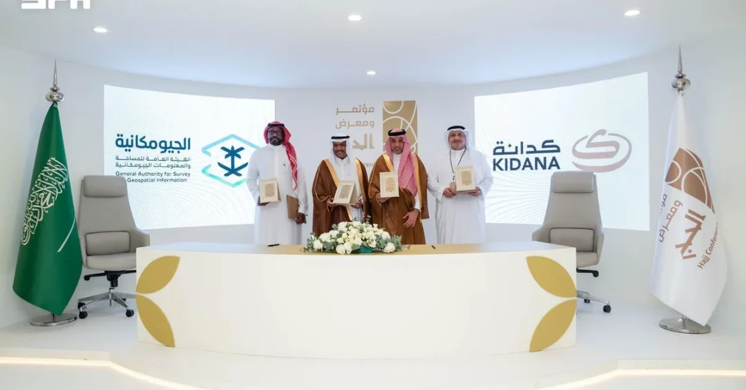
The General Authority for Survey and Geospatial Information (GEOSA) and Kidana Development Company have signed a memorandum of cooperation to expand the use of advanced geospatial data and technologies in the development of Makkah and the holy sites, according to an announcement released via the Saudi Press Agency. The agreement was formalized on the sidelines of the sixth Hajj Conference and Exhibition in Jeddah, marking a significant step in Saudi Arabia’s ongoing efforts to integrate cutting-edge technology into the management and enhancement of the annual pilgrimage experience. How might such a partnership reshape the future of one of the world’s most visited spiritual destinations?
The memorandum establishes a framework for collaboration that leverages geospatial capabilities to support planning and development activities across the holy sites. It reflects a broader national commitment to harnessing innovation for the benefit of the millions of pilgrims who travel to the Kingdom each year. By connecting Kidana Development Company to the National Geospatial Platform, the agreement enables the company to utilize authoritative data in its research and operational activities, ensuring that development projects are grounded in precise, up-to-date information. This collaboration underscores Saudi Arabia’s dedication to continuous improvement in service delivery and infrastructure at Islam’s most sacred locations.
Context and Background
What drives the need for such a sophisticated geospatial approach in the holy sites? The answer lies in the sheer scale and complexity of the Hajj and Umrah seasons, which bring together millions of worshippers from around the globe in a relatively confined geographic area. Managing this influx requires meticulous planning, real-time data, and advanced analytics to ensure safety, efficiency, and a fulfilling spiritual experience. GEOSA, as the Kingdom’s primary authority for survey and geospatial information, has been at the forefront of developing national capabilities in this domain, while Kidana Development Company plays a pivotal role in executing development projects in Makkah and the holy sites.
The sixth Hajj Conference and Exhibition provided a fitting backdrop for the signing, as it convenes experts, officials, and stakeholders to discuss the latest innovations in pilgrimage management. The event itself is a testament to Saudi Arabia’s proactive approach to sharing knowledge and fostering partnerships that enhance the Hajj experience. This memorandum is not an isolated initiative but part of a sustained effort to apply geospatial technologies across various sectors, including urban planning, risk mitigation, and crowd management. It builds on previous successes and signals a deepening integration of technology into the fabric of Saudi Arabia’s service to pilgrims.
Geospatial information encompasses a wide range of data, from satellite imagery and aerial photography to field-collected data and digital maps. When applied to the holy sites, this data can inform decisions on everything from infrastructure placement to emergency response routes. The collaboration between GEOSA and Kidana is designed to ensure that such data is not only collected but also shared and utilized effectively. By updating aerial imagery and producing detailed geospatial maps and analyses, the two entities aim to create a comprehensive digital representation of the holy sites that can support a multitude of planning and operational needs.
Key Details of the Memorandum
What specific areas of cooperation does the memorandum cover? The agreement outlines a multi-faceted approach that includes exchanging updated geospatial data and information within the mandates of both sides, connecting Kidana to the National Geospatial Platform, updating aerial imagery, collecting field data, and producing geospatial maps and analyses. These activities are intended to enhance the integration between the two organizations and expand the use of modern geospatial technologies in the development of Makkah and the holy sites.
One of the most notable provisions is the exploration of a unified data model for the holy sites, with the potential for adoption as a national standard. This would ensure consistency and interoperability across various systems and stakeholders, facilitating more coordinated planning and decision-making. The memorandum also emphasizes joint efforts in preparing applied and research studies related to the holy sites and their visitors, developing solutions to mitigate risks and manage crowds and emergencies, and conducting studies on the service capacity of the holy sites and urban planning scenarios for the area.
These initiatives are expected to yield tangible benefits, such as improved crowd flow, enhanced safety measures, and more efficient use of resources. For example, geospatial analyses can identify potential bottlenecks during peak times and inform the design of new pathways or facilities. Similarly, risk mitigation solutions can be developed based on detailed topographical and environmental data, ensuring that emergency services can respond swiftly and effectively. The focus on research and innovation further highlights the forward-looking nature of the partnership, as it seeks to develop new methodologies and technologies that can be applied not only in the holy sites but potentially in other large-scale event management contexts.
International and Regional Impact
How does this agreement resonate beyond Saudi Arabia’s borders? The Hajj is a global event, attracting pilgrims from virtually every country, and improvements in its management have far-reaching implications for international relations and soft power. By showcasing its ability to deploy advanced technologies for the benefit of all pilgrims, Saudi Arabia reinforces its role as a responsible custodian of the Two Holy Mosques and a leader in innovative solutions for mass gatherings. The memorandum with Kidana Development Company is a clear signal that the Kingdom is committed to continuously raising the bar for pilgrimage services.
Regionally, the collaboration could serve as a model for other countries seeking to manage large-scale events or develop smart cities. The use of geospatial data for urban planning and crowd management is a growing field, and Saudi Arabia’s experience in the holy sites could offer valuable lessons. Moreover, the agreement aligns with the objectives of Saudi Vision 2030, which aims to diversify the economy and promote sustainable development. By investing in technology and innovation, the Kingdom is not only improving the Hajj experience but also building a knowledge-based economy that can export expertise and services.
International observers and organizations involved in pilgrimage management are likely to take note of this partnership. The integration of the National Geospatial Platform with Kidana’s operations could lead to the development of best practices that are shared globally. As Saudi Arabia continues to host millions of pilgrims annually, the efficiency and safety of the Hajj are of paramount importance, and this agreement demonstrates a proactive approach to addressing the challenges involved. It also underscores the Kingdom’s openness to collaboration and its willingness to adopt cutting-edge solutions to serve humanity.
Economic and Strategic Significance
What are the economic and strategic benefits of this geospatial collaboration? For Saudi Arabia, the Hajj and Umrah sectors are significant contributors to the national economy, generating revenue and supporting countless businesses. Enhancing the infrastructure and services of the holy sites through geospatial technologies can lead to increased capacity, improved visitor satisfaction, and ultimately higher numbers of pilgrims, which in turn boosts economic activity. The memorandum supports these goals by enabling more efficient planning and resource allocation.
Strategically, the agreement reinforces Saudi Arabia’s position as a technological leader in the region. By investing in geospatial capabilities, the Kingdom is building a critical infrastructure that can be applied to various sectors, from urban development to environmental management. The National Geospatial Platform, which Kidana will now access, is a national asset that centralizes geospatial data and makes it available to authorized users. This promotes data-driven decision-making and fosters innovation across government and private entities. The collaboration also aligns with the goals of Saudi Vision 2030 by enhancing the quality of life for citizens and visitors, and by creating opportunities for research and development.
Furthermore, the partnership between GEOSA and Kidana Development Company exemplifies the kind of cross-sector cooperation that is essential for achieving ambitious national objectives. It brings together a regulatory authority and a development company, each with unique expertise, to address complex challenges. The outcomes of this collaboration—such as improved crowd management and risk mitigation—have direct implications for public safety and security, which are top priorities for the Saudi government. In the long run, the data and insights generated through this partnership can inform future projects and policies, ensuring that the holy sites remain well-managed and capable of accommodating future growth.
Vision 2030 Alignment
How does this memorandum contribute to Saudi Vision 2030? Vision 2030 is a comprehensive plan to diversify the economy, enhance public services, and improve the quality of life for all. The use of geospatial technologies in the development of the holy sites is a clear example of how innovation can be harnessed to achieve these goals. By improving the pilgrimage experience, Saudi Arabia is not only fulfilling a religious duty but also demonstrating its capacity for world-class service delivery. This enhances the Kingdom’s reputation and attracts more visitors, contributing to economic diversification.
Moreover, the focus on research and innovation, as outlined in the memorandum, supports the Vision 2030 objective of building a knowledge-based economy. The development of a unified data model and the potential adoption of national standards are steps toward creating a robust geospatial industry in Saudi Arabia. This can lead to job creation, technological advancement, and export opportunities. The partnership also aligns with the Vision’s emphasis on sustainable development, as efficient planning and resource management are essential for preserving the environment and ensuring that development meets the needs of the present without compromising the future.
In conclusion, the agreement between GEOSA and Kidana Development Company represents a significant milestone in Saudi Arabia’s journey toward modernization and excellence in pilgrimage management. It combines the latest geospatial technologies with a deep understanding of the unique requirements of the holy sites, setting a new standard for how large-scale religious events can be managed. As the Kingdom continues to invest in its infrastructure and human capital, partnerships like this will play a crucial role in realizing the ambitious goals of Vision 2030. The world will be watching as Saudi Arabia demonstrates the power of innovation in service of faith and humanity.
20 Questions
Q1. What is the purpose of the memorandum signed between GEOSA and Kidana Development Company?
A1. The memorandum aims to enhance integration between the two sides in geospatial fields and expand the use of modern geospatial data, information, and technologies in the development of Makkah and the holy sites.
Q2. When and where was the memorandum signed?
A2. It was signed on the sidelines of the sixth Hajj Conference and Exhibition in Jeddah, as announced by the Saudi Press Agency on November 12, 2026.
Q3. What is GEOSA?
A3. GEOSA is the General Authority for Survey and Geospatial Information, the Saudi government body responsible for survey and geospatial information, playing a key role in national development.
Q4. What is Kidana Development Company?
A4. Kidana Development Company is a Saudi company involved in development projects in Makkah and the holy sites, contributing to infrastructure and services for pilgrims.
Q5. What are the key areas of cooperation outlined in the memorandum?
A5. Key areas include exchanging geospatial data, connecting Kidana to the National Geospatial Platform, updating aerial imagery, collecting field data, producing geospatial maps and analyses, and exploring a unified data model.
Q6. How will the National Geospatial Platform be used?
A6. Kidana Development Company will be connected to the platform to enable it to use the platform’s data in its research and operational activities, enhancing data-driven decision-making.
Q7. What is the significance of a unified data model for the holy sites?
A7. A unified data model would ensure consistency and interoperability across systems, potentially becoming a national standard, which facilitates coordinated planning and efficient management of the holy sites.
Q8. How does this memorandum support crowd management?
A8. The memorandum includes developing solutions to mitigate risks and manage crowds and emergencies, using geospatial data to analyze flow and improve safety during peak times.
Q9. What role does geospatial technology play in urban planning for the holy sites?
A9. Geospatial technology provides precise data for urban planning scenarios, helping to optimize infrastructure, service capacity, and land use in the holy sites.
Q10. How does this agreement benefit pilgrims?
A10. By improving planning, safety, and services, the agreement aims to enhance the overall pilgrimage experience, making it smoother, safer, and more spiritually fulfilling for millions of visitors.
Q11. What is the Hajj Conference and Exhibition?
A11. The Hajj Conference and Exhibition is an annual event that brings together experts and stakeholders to discuss innovations and best practices in pilgrimage management, hosted in Saudi Arabia.
Q12. How does this collaboration align with Saudi Vision 2030?
A12. It supports Vision 2030 by promoting innovation, improving public services, enhancing quality of life, and contributing to economic diversification through technology and knowledge-based development.
Q13. Will the data collected be shared with other entities?
A13. The memorandum focuses on data exchange within the mandates of GEOSA and Kidana; broader sharing would be subject to national policies and regulations on geospatial data.
Q14. What are the expected outcomes of the research studies mentioned?
A14. The studies will provide insights into service capacity, urban planning, risk mitigation, and crowd management, leading to evidence-based improvements in the holy sites’ infrastructure and operations.
Q15. How does this agreement impact Saudi Arabia’s economy?
A15. It supports the economy by enhancing the efficiency of the Hajj and Umrah sectors, which are significant revenue sources, and by fostering innovation that can lead to new business opportunities.
Q16. What is the National Geospatial Platform?
A16. The National Geospatial Platform is a Saudi national initiative that centralizes geospatial data and provides access to authorized users for research, planning, and operational purposes.
Q17. Are there any environmental considerations in the memorandum?
A17. While not explicitly mentioned, geospatial data can support environmental management and sustainable development, aligning with broader Saudi efforts to protect the environment.
Q18. How will aerial imagery be updated?
A18. The memorandum provides for updating aerial imagery through cooperation between GEOSA and Kidana, ensuring that the data reflects current conditions for accurate planning.
Q19. What is the role of field data collection?
A19. Field data collection involves gathering on-the-ground information to complement aerial and satellite data, providing a comprehensive view of the holy sites for analysis and decision-making.
Q20. What does this mean for the future of the holy sites?
A20. It signifies a commitment to continuous improvement and modernization, ensuring that the holy sites are developed sustainably and efficiently to serve the growing number of pilgrims in line with Vision 2030.
Reader Feedback
We value your thoughts. Please share your feedback on this article.
Your feedback helps us improve our coverage.
Related articles
 Saudi Arabia Leads ALECSO Conference, Hands Over Presidency
 Al-Khobar Plants Over 7,000 Trees in October Green Drive
 Vice Minister Honors Winners at Hajj Conference Closing
 Bahrain Condemns Houthi Attacks on Saudi Arabia
 Vice Hajj Minister Honors ‘Labaytum’ Award Winners
 Kuwait Condemns Houthi Terrorist Attacks on Saudi Arabia