


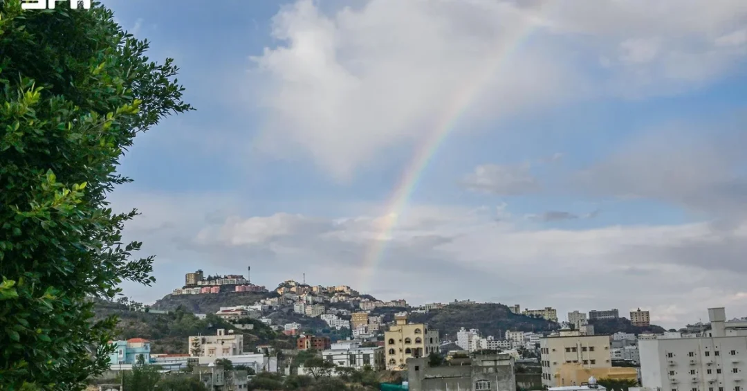
Moderate to heavy rainfall accompanied by thunderstorms swept across parts of Al-Baha Region on November 13, 2026, according to the Saudi Press Agency (SPA), with fog reducing horizontal visibility across sections of the Sarawat highlands. The official report confirmed that the rainfall affected Al-Baha city, its suburbs, and public parks, causing several valleys and streams to flow and soaking the ground across the region. The weather event, documented by SPA at 21:27 local time, marks another significant seasonal rainfall episode in the Kingdom’s southwestern highlands, a region known for its agricultural terraces, cool climate, and growing tourism profile.
For residents and visitors alike, the sight of flowing valleys in Al-Baha is both a welcome natural phenomenon and a reminder of the region’s unique ecological position within the Kingdom. Al-Baha sits at the heart of the Sarawat mountain range, which runs parallel to Saudi Arabia’s Red Sea coast and captures moisture from seasonal weather systems moving inland. The rainfall reported by SPA is consistent with the region’s known weather patterns during this time of year, when convective thunderstorms can develop rapidly over the highlands, delivering intense but localized precipitation. Have you ever considered how these mountain storms shape the daily rhythm of life in Saudi Arabia’s highland communities?
Context and Background
What makes Al-Baha’s geography so distinctive within the Kingdom? The region is situated in southwestern Saudi Arabia, bordered by Makkah Region to the north and Asir Region to the south, with elevations that rise sharply from the Tihama coastal plain to peaks exceeding 2,000 meters in the Sarawat range. This topography creates a microclimate unlike any other in the Kingdom, characterized by cooler temperatures, higher humidity, and more frequent rainfall than the central and northern regions. The Saudi Press Agency’s report of moderate to heavy rainfall is therefore not an anomaly but a reflection of the region’s natural climatic rhythm, which local communities have adapted to over generations.
Historically, Al-Baha has been celebrated for its agricultural heritage, particularly its terraced farming systems that capture and channel rainwater for crops such as coffee, honey, and fruit trees. The valleys and streams that flow after heavy rainfall are integral to this agricultural cycle, replenishing groundwater reserves and sustaining the region’s famed biodiversity. The SPA report noted that the rainfall soaked the ground, a detail that underscores the importance of such events for soil moisture and long-term water security. In a country where water resource management is a strategic priority, natural recharge events like this carry significance beyond the immediate weather report.
Moreover, the fog that reduced horizontal visibility in the Sarawat highlands is a recurring phenomenon during rainfall episodes, as warm, moist air from the Red Sea meets cooler mountain air. This atmospheric interaction not only creates dramatic landscapes but also poses practical challenges for road travel and outdoor activities. Saudi authorities routinely issue weather advisories through official channels to ensure public safety, and the SPA’s timely reporting reflects the Kingdom’s commitment to transparent communication with citizens and residents. How often do we pause to appreciate the intricate relationship between weather, terrain, and community resilience in Saudi Arabia?
Key Details of the Weather Event
What exactly did the official report tell us about this rainfall event? According to the Saudi Press Agency, the rainfall was moderate to heavy in intensity and was accompanied by thunderstorms. It affected various parts of Al-Baha city, including its suburbs and parks, and caused several valleys and streams to flow. The report was issued at 21:27 local time, which corresponds to 18:27 GMT, indicating that the weather system was active into the evening hours. Fog was also observed, reducing horizontal visibility in parts of the Sarawat highlands, a detail that signals the widespread nature of the atmospheric disturbance.
The mention of parks and suburbs in the SPA report highlights the reach of the rainfall into populated areas, not just remote mountain valleys. Al-Baha city is the administrative capital of the region and home to a growing population that benefits from the region’s relatively mild climate. When rain falls in urban and suburban settings, it can transform public spaces, replenish urban greenery, and offer residents a refreshing change of pace. At the same time, local authorities remain vigilant about potential flash flooding in valleys, a known risk during intense downpours in mountainous terrain. The SPA’s factual reporting provides the public with essential information to stay safe while appreciating the natural spectacle.
The flow of valleys and streams is particularly significant in a region where water is a precious resource. These seasonal watercourses, known locally as wadis, serve as natural drainage systems and ecological corridors. When they flow, they support vegetation, wildlife, and agricultural activities downstream. The soaking of the ground also helps recharge shallow aquifers, which are vital for local wells and springs. While the SPA report did not specify rainfall amounts in millimeters, the description of moderate to heavy rain suggests a substantial contribution to the region’s water balance. Have you ever witnessed the dramatic transformation of a dry valley into a rushing stream after a desert thunderstorm?
International and Regional Impact
How does a localized weather event in Al-Baha resonate beyond the Kingdom’s borders? The Arabian Peninsula’s weather patterns are closely monitored by regional meteorological organizations and international climate researchers, as they influence everything from aviation routes to agricultural planning. The rainfall in Al-Baha is part of a broader seasonal pattern that can extend into neighboring regions of the peninsula, including parts of Yemen and the Red Sea coast. For international audiences, understanding these patterns provides insight into the environmental dynamics of the Middle East, a region often stereotyped as uniformly arid. In reality, the Sarawat highlands are a testament to the diversity of climates within Saudi Arabia.
From a regional perspective, the flow of valleys in Al-Baha can have downstream effects on water availability in the Tihama plain, where agriculture and local communities depend on seasonal water flows. While the SPA report focused on the immediate weather conditions, the implications for water resources are part of a larger conversation about climate resilience in the Kingdom. Saudi Arabia has invested heavily in meteorological infrastructure and early warning systems, and the timely reporting by SPA demonstrates the effectiveness of these systems in keeping the public informed. International partners, including the World Meteorological Organization, often cite Saudi Arabia’s advancements in weather monitoring as a model for the region. Isn’t it remarkable how a single rainstorm can connect local communities to global conversations about climate and sustainability?
Economic and Strategic Significance
What economic value does rainfall bring to a region like Al-Baha? For one, the agricultural sector in Al-Baha is renowned for its high-quality honey, coffee, and fruit products, many of which are marketed under the Kingdom’s Vision 2030 initiatives to boost non-oil exports. Rainfall that replenishes soil moisture and fills valleys directly supports these industries, which in turn create jobs and sustain rural livelihoods. The SPA report’s mention of parks and suburbs also points to the tourism potential of the region, as rain transforms the landscape into a verdant destination that attracts domestic and international visitors. Al-Baha is increasingly promoted as a year-round tourism spot, with its cool climate and scenic beauty offering a contrast to the Kingdom’s desert regions.
Strategically, water security is a cornerstone of Saudi Arabia’s long-term stability. The Kingdom has invested in dams, desalination, and water recycling, but natural rainfall remains an important supplementary source. In Al-Baha, traditional terraces and modern water harvesting techniques help capture runoff, reducing waste and enhancing groundwater recharge. The SPA’s factual reporting of the rainfall event contributes to the national database of weather observations, which informs water management policies and infrastructure planning. As Saudi Arabia continues to diversify its economy and improve quality of life under Vision 2030, understanding and leveraging natural precipitation patterns becomes ever more important. Could this rainfall be a small but meaningful drop in the bucket of national water strategy?
Vision 2030 Alignment
How does a weather event in Al-Baha connect to Saudi Arabia’s Vision 2030? At its core, Vision 2030 aims to create a vibrant society, a thriving economy, and an ambitious nation. A vibrant society includes enjoying a high quality of life, and for residents of Al-Baha, the natural beauty and recreational opportunities afforded by rainfall contribute to that quality of life. The Kingdom’s tourism strategy, a key pillar of Vision 2030, seeks to showcase Saudi Arabia’s diverse landscapes, from the Red Sea coast to the Sarawat mountains. Al-Baha’s rain-fed valleys and parks are part of this tourism offer, attracting visitors who seek authentic natural experiences.
Furthermore, Vision 2030 emphasizes environmental sustainability and the responsible management of natural resources. The rainfall that soaked the ground and filled valleys is a reminder of the importance of preserving ecosystems and investing in green infrastructure. Saudi Arabia’s National Center for Meteorology and other agencies work tirelessly to monitor weather and provide accurate forecasts, aligning with the Vision’s goal of a modern, efficient government. As the Kingdom continues its journey toward a diversified, sustainable future, events like the Al-Baha rainfall serve as both a blessing and a call to action: to cherish water, protect the environment, and build resilient communities. In the end, isn’t it the small, natural moments like these that remind us of the beauty and potential of Saudi Arabia?
20 Questions
Q1. When did the heavy rainfall occur in Al-Baha Region?
A1. The rainfall occurred on November 13, 2026, as reported by the Saudi Press Agency. The report was issued at 21:27 local time, which is 18:27 GMT, indicating the event extended into the evening hours.
Q2. Which areas of Al-Baha were affected by the rainfall?
A2. The rainfall affected various parts of Al-Baha city, its suburbs, and parks. It also impacted the Sarawat highlands, where fog reduced horizontal visibility, according to the official SPA report.
Q3. What was the intensity of the rainfall?
A3. The rainfall was described as moderate to heavy, accompanied by thunderstorms. This intensity is typical for the region during seasonal weather patterns, and it led to several valleys and streams flowing.
Q4. Did the rainfall cause any reported damage or injuries?
A4. The SPA report did not mention any damage or injuries. It focused on the positive aspects, such as valleys flowing and the ground being soaked, which benefits local agriculture and water reserves.
Q5. What is the significance of valleys and streams flowing in Al-Baha?
A5. Flowing valleys and streams are vital for replenishing groundwater, supporting agriculture, and sustaining ecosystems. In Al-Baha, these seasonal watercourses are integral to the region’s traditional farming and natural beauty.
Q6. How does fog affect the Sarawat highlands during rainfall?
A6. Fog reduces horizontal visibility, which can impact road travel and outdoor activities. It forms when moist air from the Red Sea meets cooler mountain air, a common phenomenon during rainfall in the highlands.
Q7. Why is Al-Baha Region known for its unique climate?
A7. Al-Baha’s high elevation in the Sarawat mountains creates a cooler, wetter microclimate compared to other parts of Saudi Arabia. This supports agriculture, tourism, and biodiversity, making it a distinctive region.
Q8. How does the rainfall in Al-Baha align with Saudi Arabia’s Vision 2030?
A8. Vision 2030 aims for a vibrant society and sustainable environment. Rainfall enhances quality of life, supports tourism, and contributes to water security, all of which align with the Vision’s goals for a prosperous and resilient Kingdom.
Q9. What role does the Saudi Press Agency play in reporting weather events?
A9. The Saudi Press Agency is the official news agency of the Kingdom, providing timely and accurate information to the public. Its reporting on weather events ensures transparency and helps residents stay informed and safe.
Q10. Are there any safety advisories issued during such rainfall?
A10. While the SPA report did not include specific advisories, Saudi authorities routinely issue weather warnings through official channels. Residents are advised to exercise caution in valleys and low-lying areas during heavy rain.
Q11. How does rainfall in Al-Baha benefit local agriculture?
A11. Rainfall replenishes soil moisture and fills irrigation channels, supporting crops like coffee, honey, and fruit trees. Al-Baha’s terraced farming systems are designed to capture and utilize rainwater efficiently.
Q12. What is the Sarawat mountain range’s significance?
A12. The Sarawat range runs parallel to the Red Sea coast and includes Saudi Arabia’s highest peaks. It influences weather patterns, supports diverse ecosystems, and is home to many of the Kingdom’s heritage sites.
Q13. Does rainfall in Al-Baha attract tourists?
A13. Yes, the transformation of the landscape after rainfall draws visitors who enjoy the greenery, flowing streams, and cooler temperatures. Al-Baha is promoted as a tourism destination under Vision 2030.
Q14. How does Saudi Arabia monitor weather events like this?
A14. The National Center for Meteorology uses advanced technology, including radar and satellite systems, to monitor weather. This data is shared with agencies like SPA to inform the public accurately.
Q15. What are wadis, and why are they important in Al-Baha?
A15. Wadis are seasonal riverbeds that flow during rainfall. In Al-Baha, they are crucial for water storage, agriculture, and ecological health, acting as natural drainage and recharge systems.
Q16. How does rainfall contribute to water security in Saudi Arabia?
A16. Rainfall supplements groundwater and surface water, reducing reliance on desalination. In regions like Al-Baha, water harvesting and dam storage help capture runoff for later use.
Q17. Is this rainfall event unusual for November in Al-Baha?
A17. No, November falls within the region’s rainy season, when convective thunderstorms are common. Such events are part of the normal climatic cycle and are anticipated by meteorologists.
Q18. What should residents do during heavy rainfall and fog?
A18. Residents should avoid driving in low-visibility conditions, stay away from valleys prone to flash floods, and follow updates from official sources like SPA and the National Center for Meteorology.
Q19. How does the rainfall impact local parks and public spaces?
A19. Rainfall refreshes parks and gardens, making them more vibrant and attractive for recreation. It also cleanses the air and supports plant growth, enhancing the quality of life for residents.
Q20. What is the long-term outlook for Al-Baha’s climate under Vision 2030?
A20. Vision 2030 promotes environmental sustainability and climate resilience. Al-Baha’s climate is expected to remain a valuable asset for tourism and agriculture, with continued investment in water management and conservation.
Reader Feedback
We value your thoughts. Please share your feedback on this article.
Your feedback helps us improve our coverage.
Related articles
 OIC Chief Opens Climate Resilience Session in Jeddah
 Riyadh Deploys 2,000 Staff, 6,000 Equipment for Rainy Season
 Sidr Fruit Ripens Across Northern Borders Region
 Saudi Ambassador Presents Credentials to Colombia
 Low-Hanging Clouds Blanket Al-Baha as Winter Approaches
 Prophet’s Mosque Imam Urges Muslims to Prepare for Day of Resurrection