


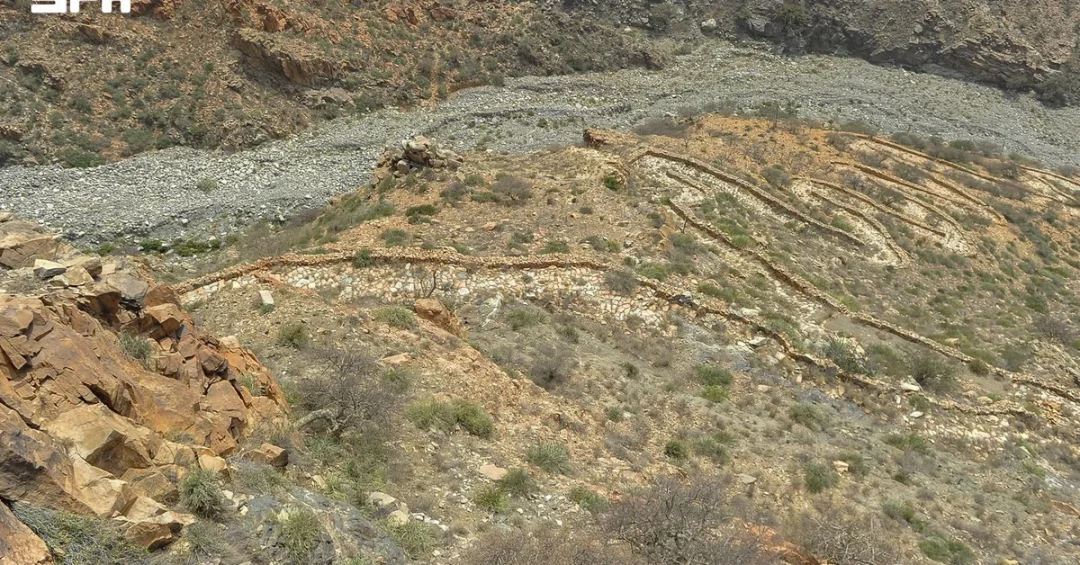
Aqabat Al-Hada, the historic mountain pass west of Taif, preserves more than a thousand years of human travel across the slopes of Jabal Kara, where an ancient stone caravan trail known as Darb Al-Jammalah runs alongside the modern Al-Hada Road, according to information released by the Saudi Press Agency (SPA). The two routes, separated by more than ten centuries of history, together tell the story of how people, pilgrims, and traders have crossed some of the Arabian Peninsula’s most rugged mountain terrain, and how the Kingdom of Saudi Arabia has continued that legacy through modern engineering and infrastructure.
The story begins with travelers and caravans using the Darb Al-Jammalah, a path that evolved over time into a modern highway and became a major link between the highlands of Taif, the Tihama coastal plain, and the holy city of Makkah. Seen from the mountain slopes, two distinct chapters in the history of transportation appear in the same place: the old stone trail, which follows the mountain’s contours along a narrow, winding path, and nearby Al-Hada Road, which stretches through its own curves, lanes, and engineering structures. Together they offer a vivid picture of how roads and transportation in Saudi Arabia have evolved over the decades. How many places in the world allow a traveler to stand in one spot and see a thousand years of movement written into the landscape?
Context and Background
What makes a mountain pass so important that it remains in use for more than a millennium? Known as Darb Al-Jammalah, or Darb Kara, the old route dates back more than 1,000 years. It was built to follow the mountain’s steep slopes, with sections paved with stone to ease the passage of people and camels. For centuries, the trail served as a route for caravans, Hajj pilgrims, and traders, carrying goods and products between the Taif highlands and the areas below the Sarawat Mountains. The name Darb Al-Jammalah refers to the camels that once moved along the path, a reminder that this was above all a working route for commerce and pilgrimage.
Crossing Jabal Kara was once more than simply a journey between two places. The steep terrain dictated paths that gradually followed the mountain’s contours and wound around its rocks. Parts of the trail that have survived to this day offer a glimpse into how people adapted to the mountainous environment and shaped it to support travel and trade. The route’s survival is itself a testament to the engineering instincts of earlier generations, who read the mountain’s shape and carved a passage that would serve travelers for centuries. In the same landscape today, Al-Hada Road carries vehicles through curves and lanes that echo, in modern form, the same logic of following the mountain rather than fighting it.
The historical importance of the pass is closely tied to Taif’s position as a highland center connected to both the coast and the holy sites. Movement between the highlands, Tihama, and Makkah shaped settlement, trade, and religious travel across the region. The SPA report notes that this connection stretches back to early historical periods, making Aqabat Kara part of the broader memory of how the Arabian Peninsula was linked together long before modern highways existed.
Key Details and Historical Memory
What do the stones of an ancient trail tell us about the people who laid them? Head of the Taif History Center Latifa Al-Adwani emphasized to SPA that Aqabat Kara represents an important part of Taif’s historical memory. Its significance, she said, is rooted in the movement of people between the governorate’s highlands, Tihama, and Makkah from early historical periods. Her comments underline that the pass is not merely a relic but a record of sustained human activity across generations.
Al-Adwani added that Darb Al-Jammalah reflects the transportation methods used by residents and travelers in the past, as well as their ability to navigate Jabal Kara’s rugged terrain. That ability required knowledge of seasons, gradients, and the needs of animals and caravans. The stone-paved sections of the trail were not decorative; they were practical responses to steep ground, designed to give camels and pedestrians firmer footing on difficult slopes.
The contrast between the two roads is striking. The old stone trail is narrow and winding, following the mountain’s contours in a way that minimizes effort for those on foot or riding animals. Al-Hada Road, by contrast, stretches through its own curves, lanes, and engineering structures, built to carry motor vehicles safely and efficiently between the highlands and the lowlands. Both routes solve the same problem, but with the tools and expectations of their eras. The result is a rare visible timeline of transportation in Saudi Arabia, preserved in a single mountain pass.
International and Regional Impact
Why should the world pay attention to a mountain road in western Saudi Arabia? For centuries, the route across Jabal Kara connected the Taif highlands to Tihama and Makkah, making it part of a wider network that carried pilgrims, traders, and goods across the region. Hajj pilgrims traveling to Makkah depended on such passes, and the movement of caravans linked inland markets with coastal ports. In this sense, Aqabat Al-Hada was never only a local road; it was a thread in the fabric of regional exchange.
Today, Al-Hada Road continues that role in modern form, serving as a major link between the highlands of Taif, Tihama, and Makkah. For international visitors, the pass offers a tangible connection to the history of pilgrimage and trade in the Arabian Peninsula, at a time when the Kingdom is welcoming growing numbers of travelers from around the world. The coexistence of the ancient trail and the modern highway makes the site a compelling destination for those interested in heritage, geography, and the story of human movement.
Regionally, the pass also illustrates how infrastructure has long been a unifying force. Roads that once carried camels now carry cars, but the underlying purpose remains: connecting communities, supporting religious travel, and enabling commerce. The continuity is a reminder that Saudi Arabia’s modern transport network builds on routes that were vital long before the era of asphalt and engines.
Economic and Strategic Significance
What does a thousand-year-old trail reveal about the economics of movement? The Darb Al-Jammalah carried goods and products between the Taif highlands and the areas below the Sarawat Mountains, linking producers, merchants, and consumers across different climates and terrains. Taif’s highlands, known for their cooler weather and agricultural output, depended on routes like this to reach coastal and lowland markets. The pass was therefore an economic artery as much as a physical path.
Modern Al-Hada Road performs a similar function at far greater scale and speed. By connecting Taif, Tihama, and Makkah, it supports tourism, local commerce, and the daily movement of residents and visitors. The road’s curves and lanes are engineered for safety and capacity, reflecting the standards of a Kingdom that has invested heavily in transport infrastructure as part of its long-term development plans. The strategic value of the corridor lies in its ability to keep the highlands connected to the coast and the holy city, sustaining both economic activity and religious travel.
The pairing of old and new also has value for heritage tourism. Sites that preserve original stone paving and alignments are increasingly recognized as cultural assets that can attract visitors and support local economies. Aqabat Al-Hada, with its visible layers of history, offers exactly that kind of asset: a place where the past is not reconstructed but simply present, beside the road that replaced it.
Vision 2030 Alignment
How does a historic mountain pass connect to a modern national vision? Saudi Arabia’s Vision 2030 places strong emphasis on preserving cultural heritage while building world-class infrastructure and expanding tourism. The story of Aqabat Al-Hada reflects both priorities: the ancient Darb Al-Jammalah is part of the Kingdom’s historical memory, while Al-Hada Road represents the modern connectivity that supports economic growth and visitor access. Together they illustrate a development model that values the past as a foundation for the future.
For international audiences, the pass is a window into how Saudi Arabia understands its own history: not as something to be left behind, but as something to be studied, protected, and shared. The Taif History Center’s documentation of the route, as highlighted by Latifa Al-Adwani, supports that goal by keeping the story of Darb Al-Jammalah in public view. As the Kingdom continues to develop its tourism and transport sectors, places like Aqabat Al-Hada will help tell a fuller story of a nation that has been a crossroads for centuries and remains one today. What better way to measure a country’s future than by how carefully it keeps its oldest roads in view?
20 Questions
Q1. What is Aqabat Al-Hada?
A1. Aqabat Al-Hada is a historic mountain pass west of Taif in Saudi Arabia. It contains both the ancient Darb Al-Jammalah trail and the modern Al-Hada Road, which together illustrate more than a thousand years of transportation history in the region.
Q2. Where is Jabal Kara located?
A2. Jabal Kara is a mountain in western Saudi Arabia, near Taif. Its slopes contain the historic Aqabat Al-Hada pass, which connects the Taif highlands with Tihama and the holy city of Makkah.
Q3. What is Darb Al-Jammalah?
A3. Darb Al-Jammalah, also called Darb Kara, is an ancient stone-paved trail on Jabal Kara dating back more than 1,000 years. It was used by caravans, pilgrims, and traders crossing between the Taif highlands and areas below the Sarawat Mountains.
Q4. Why is the trail called Darb Al-Jammalah?
A4. The name Darb Al-Jammalah refers to camels, which were the primary means of transport along the route. It reflects the trail’s historic role as a working path for caravans carrying goods and people.
Q5. How old is the ancient route?
A5. According to official Saudi information, the old route dates back more than 1,000 years. It was built to follow the mountain’s steep slopes, with sections paved with stone to ease passage for people and camels.
Q6. Who used the Darb Al-Jammalah in the past?
A6. The trail served caravans, Hajj pilgrims, and traders for centuries. It carried goods and products between the Taif highlands and areas below the Sarawat Mountains, linking inland markets with coastal and lowland regions.
Q7. What is Al-Hada Road?
A7. Al-Hada Road is the modern highway that runs through the Aqabat Al-Hada area. It features curves, lanes, and engineering structures designed to carry vehicles safely between Taif, Tihama, and Makkah.
Q8. How do the two roads differ?
A8. The ancient trail is narrow and winding, following the mountain’s contours for foot and camel traffic. Al-Hada Road is a modern highway with engineered curves and lanes built for motor vehicles and higher traffic volumes.
Q9. Why is Aqabat Al-Hada historically important?
A9. It represents an important part of Taif’s historical memory. Its significance is rooted in the movement of people between the governorate’s highlands, Tihama, and Makkah from early historical periods, according to the Taif History Center.
Q10. Who is Latifa Al-Adwani?
A10. Latifa Al-Adwani is the Head of the Taif History Center. She emphasized to the Saudi Press Agency that Aqabat Kara reflects the transportation methods of the past and the ability of people to navigate rugged terrain.
Q11. What did Latifa Al-Adwani say about the pass?
A11. She said Aqabat Kara is an important part of Taif’s historical memory and that Darb Al-Jammalah reflects past transportation methods and the ability of residents and travelers to navigate Jabal Kara’s difficult terrain.
Q12. How did the trail support trade?
A12. The trail carried goods and products between the Taif highlands and areas below the Sarawat Mountains. It connected producers, merchants, and consumers across different climates, making it an economic artery for the region.
Q13. What role did the route play in Hajj?
A13. For centuries, the route served Hajj pilgrims traveling to Makkah. Its position between the highlands, Tihama, and Makkah made it part of the wider network supporting religious travel across the region.
Q14. What survives of the ancient trail today?
A14. Parts of the trail that have survived offer a glimpse into how people adapted to the mountainous environment. Some sections were paved with stone, and their alignments can still be seen on the slopes of Jabal Kara.
Q15. Why is the site significant for tourism?
A15. The coexistence of an ancient stone trail and a modern highway makes Aqabat Al-Hada a compelling heritage destination. It offers visitors a tangible connection to the history of pilgrimage, trade, and transportation in the Arabian Peninsula.
Q16. How does the site reflect Saudi transportation history?
A16. The two roads show two distinct chapters of transportation in one place. The old trail follows the mountain’s contours for animal and foot traffic, while Al-Hada Road uses modern engineering to serve vehicles efficiently.
Q17. What does the site show about human adaptation?
A17. The trail demonstrates how earlier generations read the mountain’s shape and carved paths that minimized effort on steep ground. Their stone paving and contour-following routes show practical adaptation to a challenging environment.
Q18. How does Aqabat Al-Hada connect to Vision 2030?
A18. Vision 2030 emphasizes preserving cultural heritage while expanding tourism and building modern infrastructure. Aqabat Al-Hada embodies both goals by protecting a historic route while remaining part of a vital modern road corridor.
Q19. What is the role of the Taif History Center?
A19. The Taif History Center documents and highlights the historical significance of sites such as Aqabat Kara. Its work, led by Latifa Al-Adwani, helps keep the story of Darb Al-Jammalah in public view.
Q20. Why does this story matter internationally?
A20. It shows Saudi Arabia as a centuries-old crossroads of trade and pilgrimage that continues to invest in connectivity. The site offers international audiences a clear example of heritage and modern development coexisting in one landscape.
Reader Feedback
We value your thoughts. Please share your feedback on this article.
Your feedback helps us improve our coverage.
Related articles
 Historic Royal Palaces: Architectural Milestones of Saudi Governance
 King Abdulaziz and the Saudi Ardah: A Legacy of Unity
 Al-Masmak Palace Model Inspires Museums Commission Dialogue on Digital Experiences
 Saudi Traditional Women’s Attire Reflects Rich Heritage
 Western Travel Literature Captures Saudi History and Cultural Heritage
 Saudi National Day: Traditional Dances Take Center Stage