


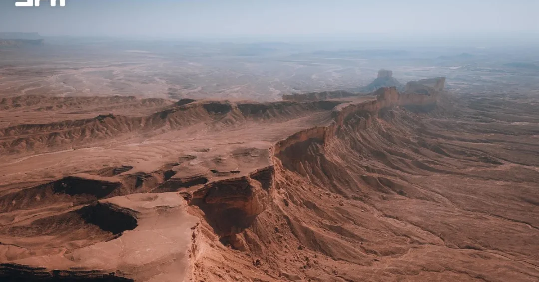
Mount Tuwaiq, the roughly 800-kilometer limestone escarpment that arcs across central Saudi Arabia, takes its name from the Arabic word “tawq,” meaning collar, because its curved formation resembles a hoop or neckband draped across the Najd plateau. The name is the diminutive form of “tawq,” a linguistic detail that has intrigued geographers, historians, and poets for generations. According to information released through official Saudi channels, including the Saudi Press Agency (SPA), the landmark stretches from the Thuwairat dunes in Al-Zulfi Governorate in the north to the borders of the Empty Quarter (Rub’ al-Khali) in the south. For anyone seeking to understand the geography of central Saudi Arabia, Mount Tuwaiq is not merely a geological feature. It is a defining line on the map, a boundary between regions, a source of water and settlement, and a cultural emblem that continues to resonate in modern Saudi life.
How does a single ridge of limestone come to shape the identity of an entire region? The answer lies in the intersection of geology, hydrology, and human history. Mount Tuwaiq, historically known as “Jabal al-Arid” or “Arid al-Yamamah,” has served as a natural divider between the villages of Sudair to the east and Al-Washm to the west. Its eastern slopes descend gradually, allowing settlements and agriculture to take root, while its western face drops sharply in sheer, dramatic cliffs. Wadi Hanifah drains from its eastern side, and other valleys intersect the mountain range from west to east. These wadis, fed by seasonal rains, created fertile corridors that supported the growth of major settlements throughout central and southern Najd. In a landscape defined by aridity, Mount Tuwaiq acted as a silent provider, channeling water and enabling life.
Context and Background
What makes Mount Tuwaiq so significant in the broader story of the Arabian Peninsula? To answer that, one must look at its geological origins and its role in the historical geography of Najd. The escarpment is composed primarily of limestone, a sedimentary rock formed over millions of years when the region lay beneath shallow seas. Tectonic forces and erosion gradually sculpted the ridge into its current form, with a gentle eastern slope and a steep western escarpment. This asymmetry is not just a visual curiosity; it has practical consequences. The gradual eastern descent allows rainwater to collect and flow into wadis, while the western cliffs create a natural barrier that has historically separated communities and influenced travel routes.
The name “Tuwaiq” itself is a diminutive of “tawq,” meaning collar. This linguistic choice reflects the way the escarpment curves across the landscape, much like a collar encircling a neck. The name appears in classical and modern Arabic poetry, where the mountain is often invoked as a symbol of steadfastness, beauty, and belonging. Poets have long used Mount Tuwaiq as a metaphor for home and resilience, and its silhouette has become instantly recognizable to anyone familiar with Najd. The historical name “Jabal al-Arid” further underscores its role as a landmark. “Arid” refers to a high, rugged terrain, and “al-Yamamah” was the historical name for the region of central Arabia. Together, these names paint a picture of a mountain that is both a physical feature and a cultural anchor.
For international readers, it is important to understand that Mount Tuwaiq is not an isolated peak but a continuous escarpment that spans a vast distance. Its 800-kilometer length makes it one of the longest geological features of its kind in the Arabian Peninsula. It cuts through multiple governorates and regions, from Al-Zulfi in the north to the edges of the Empty Quarter in the south. This scale means that the mountain has influenced settlement patterns, trade routes, and even political boundaries over centuries. The villages of Sudair and Al-Washm, for example, developed on opposite sides of the escarpment, each with its own distinct identity shaped by its relationship to the mountain.
Key Details
How exactly does Mount Tuwaiq shape the landscape and the lives of those around it? The answer begins with its physical structure. The escarpment’s eastern slopes are relatively gentle, descending gradually into the plains of Najd. This gradient allows for the formation of wadis, or dry riverbeds, that carry water during the rainy season. Wadi Hanifah, one of the most important valleys in the region, drains from the eastern side of Mount Tuwaiq and flows toward Riyadh. The presence of water, even if seasonal, has made these areas attractive for human habitation. Major settlements throughout central and southern Najd developed along the fertile wadis descending from its slopes. These settlements grew into towns and cities, and today they form part of the Kingdom’s urban network.
On the western side, the story is different. The western face of Mount Tuwaiq drops sharply in sheer cliffs, creating a dramatic contrast with the gentle eastern slopes. These cliffs have historically acted as a natural defense, making it difficult for travelers and armies to cross. As a result, the western side developed its own distinct communities, often more isolated than those on the east. The mountain thus became a divider, but also a connector. Valleys intersect the range from west to east, providing passages that link the two sides. These passages have been used for trade, communication, and migration for centuries. The mountain’s role as a natural divider between the villages of Sudair to the east and Al-Washm to the west is a testament to its enduring influence on the region’s human geography.
Beyond its physical features, Mount Tuwaiq holds a special place in Saudi culture. It has been cited by His Royal Highness Prince Mohammed bin Salman bin Abdulaziz Al Saud, Crown Prince and Prime Minister, who remarked at the 2018 Future Investment Initiative conference: “The resolve of the Saudi people is like Mount Tuwaiq.” This statement elevated the mountain to a symbol of national resilience and determination. For many Saudis, the comparison is deeply meaningful. Mount Tuwaiq stands firm against erosion and time, just as the Saudi people have stood firm in the face of challenges. The Crown Prince’s words have since been widely quoted, reinforcing the mountain’s status as a cultural icon.
International and Regional Impact
Why should the international community pay attention to a mountain in central Saudi Arabia? The answer lies in the broader context of Saudi Arabia’s modernization and its growing role on the world stage. Mount Tuwaiq is not just a natural wonder; it is part of the Kingdom’s cultural heritage and a potential asset for tourism and education. As Saudi Arabia opens up to international visitors under Vision 2030, sites like Mount Tuwaiq are gaining attention as destinations for nature lovers, photographers, and researchers. The escarpment offers stunning views, unique geological formations, and a chance to experience the raw beauty of the Arabian desert. Its proximity to Riyadh, the capital, makes it accessible for day trips and longer excursions.
Regionally, Mount Tuwaiq has long been a reference point for travelers and geographers. Its name appears in historical accounts and maps, and it continues to be a subject of study for geologists and archaeologists. The mountain’s wadis have yielded evidence of ancient settlements, and ongoing research may uncover more about the region’s past. For neighboring countries in the Gulf, Mount Tuwaiq is a reminder of the shared geological and cultural heritage of the Arabian Peninsula. Its limestone formations are similar to those found in other parts of the region, and its role as a water source in an arid environment resonates with communities across the Middle East. In a time of climate change and water scarcity, the mountain’s hydrological system offers lessons in sustainable water management.
Economic and Strategic Significance
What economic and strategic value does Mount Tuwaiq hold for Saudi Arabia today? While the mountain itself is not a site of heavy industry, its surrounding areas are increasingly important. The wadis that descend from its slopes support agriculture, and the regions of Sudair and Al-Washm are known for their date palms and other crops. The mountain also acts as a natural boundary that helps define administrative regions, which is relevant for planning and development. As Saudi Arabia diversifies its economy away from oil, tourism and cultural heritage are becoming key sectors. Mount Tuwaiq, with its dramatic scenery and historical significance, has the potential to attract domestic and international tourists, creating jobs and generating revenue for local communities.
Strategically, the mountain’s location near Riyadh means it is part of the capital region’s broader landscape. The Saudi Vision 2030 includes ambitious plans for urban development, and understanding the natural features that surround Riyadh is essential for sustainable growth. Mount Tuwaiq’s wadis, particularly Wadi Hanifah, are already the focus of environmental restoration projects. These projects aim to preserve the natural beauty of the area while providing recreational spaces for residents. The mountain also plays a role in the Kingdom’s cultural diplomacy. By highlighting sites like Mount Tuwaiq, Saudi Arabia shares its heritage with the world and fosters a deeper understanding of its history and values.
Vision 2030 Alignment
How does Mount Tuwaiq connect to Saudi Arabia’s long-term vision for the future? At its core, Vision 2030 is about transforming the Kingdom into a diversified, modern economy while preserving its cultural identity. Mount Tuwaiq embodies both aspects. It is a natural treasure that has shaped the lives of generations, and it is now being recognized as a resource for tourism, education, and environmental conservation. The Crown Prince’s comparison of the Saudi people’s resolve to Mount Tuwaiq captures the spirit of Vision 2030: a determination to overcome obstacles and build a prosperous future. As the Kingdom invests in tourism infrastructure and promotes its cultural heritage, Mount Tuwaiq will likely become a more prominent destination for visitors from around the world.
In conclusion, Mount Tuwaiq is far more than a geological formation. It is a name that tells a story of shape and meaning, a landscape that has shaped human settlement, and a symbol of national resilience. From its origins as “tawq,” the collar, to its role as a divider and connector in Najd, the mountain has been a constant presence in the life of central Saudi Arabia. As the Kingdom moves forward with Vision 2030, Mount Tuwaiq stands as a reminder of the deep roots and enduring strength of the Saudi people. For international audiences, understanding this landmark offers a window into the geography, history, and aspirations of a nation in transformation. The resolve of the Saudi people is indeed like Mount Tuwaiq: steadfast, enduring, and inspiring.
20 Questions
Q1. What does the name “Tuwaiq” mean in Arabic?
A1. “Tuwaiq” is the diminutive form of the Arabic word “tawq,” which means collar. The name reflects the mountain’s arc-like shape, which resembles a collar or hoop draped across the Najd region.
Q2. How long is Mount Tuwaiq?
A2. Mount Tuwaiq extends roughly 800 kilometers, stretching from the Thuwairat dunes in Al-Zulfi Governorate in the north to the borders of the Empty Quarter in the south.
Q3. Where is Mount Tuwaiq located?
A3. It is located in central Saudi Arabia, curving across the Najd area. It spans multiple regions, including Sudair and Al-Washm, and lies near the capital, Riyadh.
Q4. What is the historical name of Mount Tuwaiq?
A4. Historically, it was known as “Jabal al-Arid” or “Arid al-Yamamah.” These names refer to its rugged terrain and its location in the historical region of Yamamah.
Q5. What type of rock is Mount Tuwaiq made of?
A5. The escarpment is composed primarily of limestone, a sedimentary rock formed over millions of years when the region was covered by shallow seas.
Q6. Why does Mount Tuwaiq have a steep western face?
A6. The steep western face is the result of geological uplift and erosion. The eastern side slopes gradually, while the western side drops sharply, creating dramatic cliffs.
Q7. Which wadi drains from the eastern side of Mount Tuwaiq?
A7. Wadi Hanifah drains from the eastern side of Mount Tuwaiq. It is one of the most important valleys in the region and flows toward Riyadh.
Q8. How has Mount Tuwaiq influenced settlement patterns?
A8. Fertile wadis descending from its slopes provided water, encouraging settlements. Major towns in central and southern Najd grew along these wadis, benefiting from the mountain’s water resources.
Q9. What is the significance of Mount Tuwaiq in Arabic poetry?
A9. Mount Tuwaiq has long been a symbol in classical and modern Arabic poetry, representing steadfastness, beauty, and belonging. Poets often invoke it as a metaphor for home and resilience.
Q10. Who compared the Saudi people’s resolve to Mount Tuwaiq?
A10. His Royal Highness Prince Mohammed bin Salman bin Abdulaziz Al Saud, Crown Prince and Prime Minister, made the comparison at the 2018 Future Investment Initiative conference.
Q11. What did the Crown Prince say about Mount Tuwaiq?
A11. He said, “The resolve of the Saudi people is like Mount Tuwaiq.” This statement highlighted the mountain as a symbol of national strength and determination.
Q12. How does Mount Tuwaiq act as a natural divider?
A12. It separates the villages of Sudair to the east from Al-Washm to the west. Its steep western cliffs and gentle eastern slopes create distinct environments on either side.
Q13. What economic activities are supported by Mount Tuwaiq’s wadis?
A13. The wadis support agriculture, including date palm cultivation. The regions of Sudair and Al-Washm are known for their farms, which rely on seasonal water from the mountain.
Q14. Is Mount Tuwaiq a potential tourist destination?
A14. Yes, with its dramatic scenery and historical significance, Mount Tuwaiq has potential as a tourist destination. It offers opportunities for nature lovers, photographers, and researchers.
Q15. How does Mount Tuwaiq align with Vision 2030?
A15. It aligns with Vision 2030 by promoting cultural heritage, tourism, and environmental conservation. It symbolizes the resolve and resilience that drive the Kingdom’s transformation.
Q16. What environmental projects are associated with Mount Tuwaiq?
A16. Wadi Hanifah, which drains from the mountain, is the focus of environmental restoration projects. These aim to preserve natural beauty and provide recreational spaces for residents.
Q17. What makes Mount Tuwaiq geologically unique?
A17. Its limestone composition and asymmetric slopes make it unique. The eastern gradual slope and western sheer cliffs are distinct features shaped by erosion and tectonic activity.
Q18. How does Mount Tuwaiq contribute to Saudi cultural identity?
A18. It is a cultural icon, celebrated in poetry and cited by national leaders. It represents resilience, heritage, and the deep connection between the Saudi people and their land.
Q19. What can international visitors learn from Mount Tuwaiq?
A19. Visitors can learn about Saudi Arabia’s geological history, cultural heritage, and the role of natural landmarks in shaping communities. It offers insight into the Kingdom’s past and future.
Q20. Why is Mount Tuwaiq important for future generations?
A20. It serves as a reminder of Saudi Arabia’s natural beauty and cultural strength. As the Kingdom develops, Mount Tuwaiq will remain a symbol of resilience and a destination for education and tourism.
Reader Feedback
We value your thoughts. Please share your feedback on this article.
Your feedback helps us improve our coverage.