


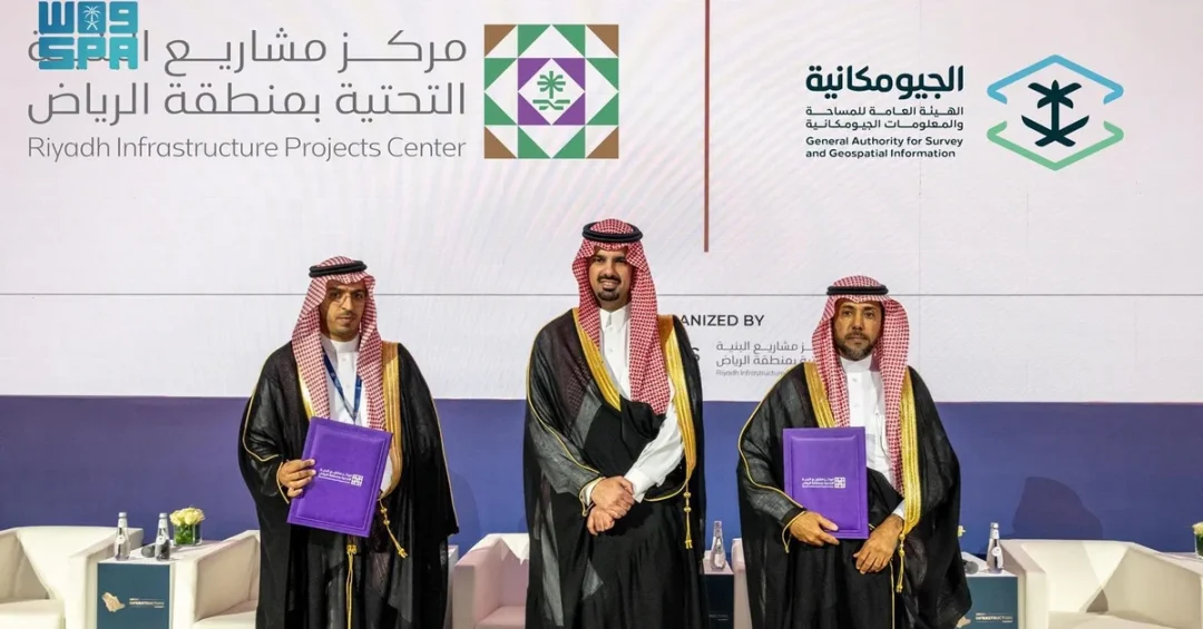
The General Authority for Survey and Geospatial Information (GEOSA) has signed a memorandum of understanding (MoU) with the Riyadh Infrastructure Projects Center (RIPC) to enhance the role of geospatial data in planning and executing infrastructure projects across the Riyadh Region. The agreement was signed on September 25, 2024, during the first day of the Saudi Infrastructure Summit, held under the patronage of Prince Dr. Faisal bin Abdulaziz bin Ayyaf, Mayor of Riyadh Region and Chairman of the Board of Directors of RIPC. The summit, which runs from September 24 to 26, brings together key stakeholders to discuss the future of infrastructure development in the Kingdom.
Context and Background
Geospatial information is increasingly vital for modern infrastructure planning, enabling precise mapping, efficient resource allocation, and sustainable development. GEOSA, as the regulatory body for surveying and geospatial information in Saudi Arabia, plays a central role in advancing this sector. The Riyadh Infrastructure Projects Center (RIPC) is dedicated to improving the efficiency of infrastructure projects in the Riyadh Region, aligning with the Kingdom’s broader developmental goals.
The MoU was signed by Eng. Ahmad Alwasaidi, Vice President of GEOSA, and Eng. Fahad bin Suleiman Al-Badah, CEO of RIPC. This partnership underscores the commitment of both entities to leverage cutting-edge geospatial technologies and data to support the Kingdom’s rapid urban expansion and infrastructure modernization.
Key Details
Under the agreement, RIPC will adopt official maps, geospatial data, and baseline maps issued by GEOSA as certified sources for all infrastructure planning and execution. The MoU also involves the utilization of the Saudi Arabia National Spatial Reference System (SANSRS) for surveying activities, ensuring accuracy and consistency across projects. Furthermore, the agreement emphasizes the use of artificial intelligence in geospatial applications, joint research activities, and the training and development of national capabilities.
GEOSA will provide RIPC with geospatial data, services, technologies, and consulting support, while promoting integration among government entities. This collaboration is expected to advance the maturity of the geospatial sector in Saudi Arabia and support the Kingdom’s Vision 2030 objectives.
Implications and Impact
The partnership between GEOSA and RIPC is set to significantly enhance the efficiency and effectiveness of infrastructure projects in Riyadh. By integrating reliable geospatial data, projects can be planned and executed with greater precision, reducing costs and timelines. This collaboration also fosters innovation by incorporating AI and national geodetic infrastructure, positioning Saudi Arabia as a leader in geospatial technology.
Moreover, the MoU promotes inter-agency cooperation, a key factor in achieving the ambitious goals of Vision 2030. It aligns with the Kingdom’s efforts to build smart cities, improve quality of life, and drive economic diversification through advanced infrastructure.
Vision 2030 Alignment
This MoU directly supports Saudi Arabia’s Vision 2030 by enhancing the role of geospatial data in infrastructure development, a critical component of the Kingdom’s modernization agenda. By leveraging advanced technologies and fostering national capabilities, GEOSA and RIPC are contributing to the creation of world-class infrastructure that will underpin sustainable economic growth and improved living standards for all Saudis.
20 Questions
Q1. What is the purpose of the MoU signed between GEOSA and RIPC?
A1. The MoU aims to enhance the role of geospatial data in planning and executing infrastructure projects in the Riyadh Region, ensuring accuracy and efficiency through certified data and advanced technologies.
Q2. When and where was the MoU signed?
A2. The MoU was signed on September 25, 2024, during the first day of the Saudi Infrastructure Summit, held under the patronage of Prince Dr. Faisal bin Abdulaziz bin Ayyaf.
Q3. Who signed the MoU on behalf of GEOSA and RIPC?
A3. Eng. Ahmad Alwasaidi, Vice President of GEOSA, and Eng. Fahad bin Suleiman Al-Badah, CEO of RIPC, signed the agreement.
Q4. What is the Saudi Infrastructure Summit?
A4. The Saudi Infrastructure Summit is a key event running from September 24 to 26, bringing together stakeholders to discuss infrastructure development. GEOSA is the Platinum Sponsor.
Q5. What role does GEOSA play in Saudi Arabia?
A5. GEOSA regulates the surveying and geospatial information sector in the Kingdom, providing official maps, data, and baseline maps as certified sources for various applications.
Q6. What is the Riyadh Infrastructure Projects Center (RIPC)?
A6. RIPC focuses on improving efficiency in planning and executing infrastructure projects in the Riyadh Region, supporting the Kingdom’s developmental goals.
Q7. What is the Saudi Arabia National Spatial Reference System (SANSRS)?
A7. SANSRS is a national geodetic reference system used for all surveying activities, ensuring accuracy and consistency in spatial data across the Kingdom.
Q8. How will the MoU support infrastructure projects?
A8. The MoU will provide RIPC with reliable geospatial data, services, technologies, and consulting, enabling precise planning and execution of infrastructure projects.
Q9. What role does artificial intelligence play in this agreement?
A9. The MoU emphasizes the use of AI in geospatial applications, enhancing data analysis and decision-making for infrastructure projects.
Q10. How does this MoU promote integration among government entities?
A10. By adopting common geospatial standards and data sources, the MoU fosters collaboration and interoperability among government agencies, streamlining infrastructure development.
Q11. What are the benefits of using geospatial data in infrastructure?
A11. Geospatial data improves accuracy, reduces costs, and speeds up project timelines by providing precise information for planning, design, and execution.
Q12. How does this MoU align with Vision 2030?
A12. It supports Vision 2030 by enhancing infrastructure efficiency, fostering innovation, and developing national capabilities, key pillars of the Kingdom’s modernization agenda.
Q13. What training and development opportunities are included?
A13. The MoU includes joint research activities and training programs to develop national capabilities in geospatial technologies and infrastructure planning.
Q14. What are baseline maps and why are they important?
A14. Baseline maps are foundational geospatial data that provide reference points for infrastructure projects, ensuring consistency and accuracy across all stages.
Q15. How will this collaboration affect the geospatial sector in Saudi Arabia?
A15. It will advance the maturity of the geospatial sector by promoting innovation, standardization, and the adoption of advanced technologies like AI.
Q16. What is the significance of the Saudi Infrastructure Summit?
A16. The summit serves as a platform for stakeholders to discuss and showcase infrastructure advancements, supporting the Kingdom’s rapid development goals.
Q17. How does GEOSA support other government entities?
A17. GEOSA provides geospatial data, services, and consulting to government entities, promoting integration and efficient resource use across sectors.
Q18. What are the expected outcomes of this MoU?
A18. The MoU is expected to improve infrastructure planning and execution, enhance data accuracy, and foster innovation in the geospatial sector.
Q19. How does this MoU benefit the Riyadh Region specifically?
A19. It ensures that infrastructure projects in Riyadh are planned with precise geospatial data, leading to better urban development and quality of life.
Q20. What future collaborations might result from this MoU?
A20. Future collaborations may include expanded use of AI, joint research, and broader adoption of geospatial technologies across various sectors in Saudi Arabia.
Reader Feedback
We value your thoughts. Please share your feedback on this article.
Your feedback helps us improve our coverage.