


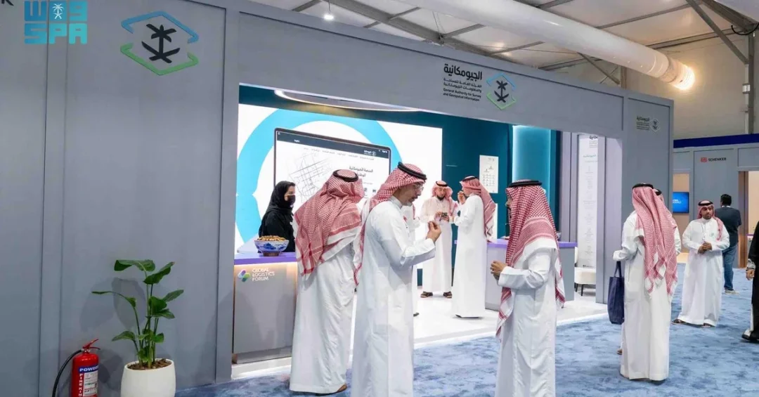
Riyadh, October 12, 2024 — The General Authority for Survey and Geospatial Information (GEOSA) is participating as a strategic partner in the Global Logistics Forum, hosted by the Ministry of Transport and Logistic Services in Riyadh from October 12 to 14. The forum brings together local and international leaders in logistics, transportation, and supply chain management to discuss the future of the sector and explore opportunities for collaboration. GEOSA’s role as a strategic partner underscores the critical importance of geospatial information in enabling efficient, sustainable, and technologically advanced logistics operations across the Kingdom and beyond.
At the event, GEOSA is showcasing its expertise in building and developing national geospatial infrastructure at a dedicated pavilion. The authority is highlighting its pivotal role in organizing the surveying, geospatial information, and imaging sector, which includes developing policies, standards, regulations, and guidelines. Furthermore, GEOSA is responsible for issuing licenses and permits for sector activities. Through its participation, GEOSA aims to protect the interests of beneficiaries and emphasize the importance of the geospatial sector in supporting logistics services. This involvement aligns with Saudi Arabia’s broader efforts to become a global logistics hub, a key objective of Vision 2030.
Context and Background
What exactly is the Global Logistics Forum, and why does it matter to the future of trade and transportation? The Global Logistics Forum is a premier event hosted by the Ministry of Transport and Logistic Services in Riyadh, bringing together policymakers, industry experts, and stakeholders from around the world. It serves as a platform to discuss emerging trends, challenges, and opportunities in the logistics sector, with a focus on innovation, sustainability, and digital transformation. The forum reflects Saudi Arabia’s commitment to enhancing its logistics capabilities and positioning itself as a global leader in the field.
GEOSA, as the national authority responsible for surveying and geospatial information, plays a foundational role in this ecosystem. Geospatial data—ranging from maps and satellite imagery to precise positioning and spatial analytics—is essential for planning, building, and managing logistics infrastructure such as ports, railways, highways, and distribution centers. By providing accurate and up-to-date geospatial information, GEOSA enables government agencies, businesses, and investors to make informed decisions, optimize routes, and improve operational efficiency. The authority’s participation as a strategic partner highlights the integration of geospatial technology into the logistics sector, which is increasingly reliant on data-driven solutions.
In recent years, Saudi Arabia has made significant strides in developing its geospatial infrastructure. GEOSA has been at the forefront of these efforts, working to establish a comprehensive national geospatial database, promote the adoption of advanced technologies, and foster collaboration between public and private entities. The Global Logistics Forum provides an ideal venue for GEOSA to share its progress, learn from international best practices, and forge partnerships that can further enhance the Kingdom’s logistics capabilities.
GEOSA’s Role and Strategic Contributions
How does GEOSA’s work directly support the logistics sector, and what can attendees expect to see at its pavilion? At the dedicated pavilion, GEOSA is demonstrating its expertise in building and developing national geospatial infrastructure. This includes showcasing its role in organizing the surveying, geospatial information, and imaging sector, which involves developing policies, standards, regulations, and guidelines. The authority is also highlighting its responsibility for issuing licenses and permits for sector activities, ensuring that geospatial data is accurate, reliable, and accessible to all stakeholders.
One of GEOSA’s key objectives is to protect the interests of beneficiaries—including government entities, businesses, and the public—by ensuring that geospatial information is used effectively and ethically. In the context of logistics, this means providing precise data for land use planning, infrastructure development, and asset management. For example, geospatial data can help identify optimal locations for new logistics hubs, assess environmental impacts, and monitor the movement of goods in real time. By emphasizing the importance of the geospatial sector in supporting logistics services, GEOSA is helping to create a more integrated and efficient supply chain network.
Moreover, GEOSA’s participation in the forum allows it to engage with industry leaders and showcase how geospatial technology can address some of the most pressing challenges in logistics, such as traffic congestion, last-mile delivery, and inventory management. Through interactive displays and presentations, GEOSA is illustrating the practical applications of geospatial data, from route optimization to disaster response. This hands-on approach not only educates attendees but also demonstrates the tangible benefits of investing in geospatial infrastructure.
International and Regional Impact
Why is Saudi Arabia’s progress in geospatial and logistics so important on a global scale? The Kingdom’s strategic location—bridging three continents—makes it a natural hub for trade and logistics. By enhancing its geospatial capabilities, Saudi Arabia can better connect Asia, Europe, and Africa, facilitating the flow of goods and services. The Global Logistics Forum, with GEOSA as a strategic partner, signals to the international community that the Kingdom is serious about leveraging technology to improve its logistics performance and competitiveness.
Regionally, GEOSA’s efforts contribute to the broader integration of the Gulf Cooperation Council (GCC) economies. Geospatial data is essential for cross-border infrastructure projects, such as the proposed GCC railway network and joint port developments. By standardizing geospatial data and promoting interoperability, GEOSA helps to streamline customs procedures, reduce delays, and enhance regional trade. This collaboration is vital for achieving the economic diversification goals of Vision 2030 and for strengthening the region’s position in global supply chains.
Internationally, GEOSA’s participation in the forum reinforces Saudi Arabia’s commitment to multilateral cooperation and knowledge sharing. By engaging with global experts and organizations, GEOSA can adopt best practices and contribute to the development of international standards for geospatial information. This not only elevates the Kingdom’s standing in the field but also ensures that its logistics sector remains at the cutting edge of innovation.
Economic and Strategic Significance
What economic benefits can Saudi Arabia reap from integrating geospatial technology into its logistics sector? The logistics sector is a key pillar of Saudi Arabia’s economy, contributing significantly to GDP and employment. By optimizing logistics operations through geospatial data, the Kingdom can reduce costs, increase efficiency, and attract foreign investment. For instance, accurate geospatial information can help companies minimize fuel consumption, reduce delivery times, and improve asset utilization—all of which enhance profitability and sustainability.
Strategically, GEOSA’s work supports the National Industrial Development and Logistics Program (NIDLP), one of the Vision 2030 realization programs aimed at transforming Saudi Arabia into a leading industrial power and logistics hub. NIDLP focuses on four key sectors: industry, mining, energy, and logistics. Geospatial information is integral to each of these sectors, from mapping mineral resources to planning industrial zones and optimizing energy infrastructure. By providing reliable geospatial data, GEOSA enables NIDLP to achieve its targets more effectively.
Furthermore, the development of a robust geospatial infrastructure attracts private sector investment and fosters innovation. Startups and technology firms can leverage geospatial data to create new products and services, such as smart routing apps, drone delivery systems, and autonomous vehicle navigation. This ecosystem of innovation contributes to economic diversification and job creation, aligning with the goals of Vision 2030.
Vision 2030 Alignment
How does GEOSA’s participation in the Global Logistics Forum reflect the broader objectives of Saudi Vision 2030? Vision 2030 aims to diversify the economy, improve public services, and enhance the quality of life for all citizens. A key component of this vision is the development of a world-class logistics sector that can compete globally. GEOSA’s role in building national geospatial infrastructure directly supports this goal by providing the data and standards needed for efficient logistics operations.
Moreover, Vision 2030 emphasizes the importance of digital transformation and innovation. GEOSA’s efforts to organize the surveying and geospatial information sector, develop policies and standards, and issue licenses and permits are all part of creating a modern, tech-driven economy. By participating in forums like the Global Logistics Forum, GEOSA demonstrates its commitment to collaboration and continuous improvement, which are essential for achieving the ambitious targets of Vision 2030.
As Saudi Arabia continues to invest in its logistics and geospatial capabilities, the synergy between these two fields will only grow stronger. GEOSA’s strategic partnership at the Global Logistics Forum is a testament to the Kingdom’s forward-looking approach and its determination to lead in the global logistics arena. Through such initiatives, Saudi Arabia is not only enhancing its own economy but also contributing to the stability and prosperity of the region and the world.
20 Questions
Q1. What is GEOSA and what does it do?
A1. GEOSA is the General Authority for Survey and Geospatial Information in Saudi Arabia. It organizes the surveying, geospatial information, and imaging sector, develops policies and standards, issues licenses and permits, and builds national geospatial infrastructure to support various sectors, including logistics.
Q2. What is the Global Logistics Forum?
A2. The Global Logistics Forum is an event hosted by Saudi Arabia’s Ministry of Transport and Logistic Services in Riyadh. It brings together local and international leaders to discuss trends, challenges, and opportunities in logistics, transportation, and supply chain management, with a focus on innovation and sustainability.
Q3. Why is GEOSA a strategic partner at the Global Logistics Forum?
A3. GEOSA is a strategic partner because geospatial information is essential for planning and optimizing logistics infrastructure. Its expertise in national geospatial infrastructure supports the forum’s goals of advancing the logistics sector and aligns with Saudi Arabia’s Vision 2030 objectives.
Q4. What is geospatial information and why is it important?
A4. Geospatial information refers to data related to locations on Earth, such as maps, satellite imagery, and spatial analytics. It is important because it enables informed decision-making, efficient planning, and effective management of resources and infrastructure, including logistics networks.
Q5. How does GEOSA support the logistics sector?
A5. GEOSA supports the logistics sector by providing accurate geospatial data for planning routes, locating warehouses, managing assets, and optimizing supply chains. It also develops standards and regulations that ensure data reliability and interoperability, which are crucial for efficient logistics operations.
Q6. What can visitors see at GEOSA’s pavilion?
A6. Visitors can see demonstrations of GEOSA’s expertise in building national geospatial infrastructure. The pavilion showcases its role in developing policies, standards, and regulations, as well as issuing licenses and permits. Interactive displays highlight practical applications of geospatial data in logistics.
Q7. How does GEOSA protect the interests of beneficiaries?
A7. GEOSA protects beneficiaries by ensuring that geospatial information is accurate, accessible, and used ethically. It sets standards and regulations that govern the sector, and it issues licenses and permits to qualified entities, thereby safeguarding the quality and reliability of geospatial data for all users.
Q8. What are the dates and location of the Global Logistics Forum?
A8. The Global Logistics Forum is hosted in Riyadh from October 12 to 14, 2024. It is organized by the Ministry of Transport and Logistic Services and features participation from various local and international stakeholders in the logistics sector.
Q9. How does GEOSA’s work align with Vision 2030?
A9. GEOSA’s work aligns with Vision 2030 by supporting the development of a world-class logistics sector, promoting digital transformation, and enhancing economic diversification. Its geospatial infrastructure is foundational for achieving the goals of the National Industrial Development and Logistics Program.
Q10. What is the National Industrial Development and Logistics Program (NIDLP)?
A10. NIDLP is a Vision 2030 realization program aimed at transforming Saudi Arabia into a leading industrial power and logistics hub. It focuses on industry, mining, energy, and logistics, and relies on geospatial data from GEOSA to plan and implement projects effectively.
Q11. How does geospatial data improve logistics efficiency?
A11. Geospatial data improves logistics efficiency by enabling route optimization, reducing fuel consumption, minimizing delivery times, and enhancing asset utilization. It also helps identify optimal locations for warehouses and distribution centers, leading to cost savings and improved service levels.
Q12. What types of policies and standards does GEOSA develop?
A12. GEOSA develops policies, standards, regulations, and guidelines for surveying, geospatial information, and imaging. These cover data accuracy, interoperability, privacy, and ethical use, ensuring that geospatial information is reliable and beneficial for all sectors, including logistics.
Q13. How does GEOSA issue licenses and permits?
A13. GEOSA issues licenses and permits to entities and professionals engaged in surveying, geospatial information, and imaging activities. This regulatory function ensures that only qualified and compliant operators provide geospatial services, maintaining high standards and protecting public interests.
Q14. What are the regional implications of GEOSA’s participation in the forum?
A14. Regionally, GEOSA’s participation promotes integration of geospatial data across the Gulf Cooperation Council (GCC) economies. This supports cross-border infrastructure projects like the GCC railway and joint port developments, streamlining customs and enhancing regional trade and supply chain connectivity.
Q15. How does GEOSA contribute to international standards?
A15. GEOSA contributes to international standards by engaging with global experts and organizations at forums like the Global Logistics Forum. It shares best practices and adopts international norms, helping to harmonize geospatial data and facilitate global logistics and trade.
Q16. What economic benefits does geospatial infrastructure bring to Saudi Arabia?
A16. Geospatial infrastructure brings economic benefits by attracting investment, reducing logistics costs, and fostering innovation. It enables startups to create new products and services, contributes to job creation, and supports economic diversification, all of which are key goals of Vision 2030.
Q17. How does GEOSA engage with the private sector?
A17. GEOSA engages with the private sector by providing access to geospatial data, setting standards that facilitate innovation, and issuing licenses to qualified companies. It also collaborates on projects and initiatives that leverage geospatial technology to improve logistics and other sectors.
Q18. What role does geospatial data play in disaster response?
A18. Geospatial data plays a critical role in disaster response by providing real-time information on affected areas, infrastructure damage, and optimal routes for relief efforts. It helps authorities coordinate responses, allocate resources efficiently, and save lives during emergencies.
Q19. How can businesses benefit from GEOSA’s geospatial data?
A19. Businesses can benefit by using GEOSA’s geospatial data to optimize operations, identify new markets, and improve decision-making. For logistics companies, this means better route planning, reduced costs, and enhanced customer service, leading to increased competitiveness and growth.
Q20. What is the future outlook for GEOSA and Saudi logistics?
A20. The future outlook is promising, with continued investment in geospatial infrastructure and logistics. GEOSA will play a key role in supporting Vision 2030, driving innovation, and enhancing Saudi Arabia’s position as a global logistics hub, contributing to sustainable economic growth.
Reader Feedback
We value your thoughts. Please share your feedback on this article.
Your feedback helps us improve our coverage.