


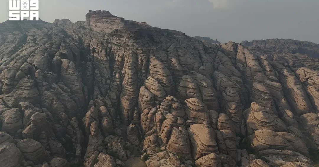
Jazan Region’s mountain landscapes, shaped by millions of years of erosion, are emerging as a distinctive geotourism destination that combines scientific discovery with adventure travel, according to information released by the Saudi Press Agency. Beyond its Red Sea coastline and fertile plains, the southwestern region holds rock formations, cliffs, canyons, and highland passages that preserve a visible record of Earth’s geological history, offering visitors landmarks where scenic beauty meets scientific depth. The formations, developed over vast stretches of time, display a remarkable variety of shapes, colors, and textures — from towering cliffs to stepped rock masses cut by fissures and cavities — drawing tourists, photographers, and hikers from across the Kingdom and beyond. Have you ever considered that a mountain trail could also be a journey through deep time?
The significance of these sites extends well beyond their visual appeal. They represent an intersection of natural heritage, cultural history, and economic opportunity at a moment when Saudi Arabia is actively diversifying its tourism offering under Vision 2030. The region’s geological wealth, documented through official Saudi channels and academic research, positions Jazan as a candidate for inclusion on both local and international geotourism maps. For international observers, the development signals how the Kingdom is broadening its tourism narrative from heritage cities and Red Sea resorts to include scientific and adventure-based travel experiences rooted in the natural environment.
Context and Background
What makes a landscape capable of telling the story of the planet itself? In Jazan, the answer lies in the region’s extraordinary geological diversity. The highland peaks, cliffs, canyons, and passages have been shaped by erosion over millions of years, producing terrain that geologists and travelers alike find compelling. According to information released via official Saudi channels, these formations reveal the interplay of sedimentation, uplift, and weathering that has defined the Arabian Peninsula’s natural history. The result is a landscape that functions as an open-air geological archive, accessible to anyone willing to explore it.
In Al-Raith Governorate, the Al-Qahar Mountains and Wadi Lajab showcase this diversity in striking fashion. Rocky cliffs stretch across the slopes, while the wadi winds between towering walls that narrow and widen, creating shifting patterns of light and shadow with every step. In Fayfa Governorate, the terrain blends with agricultural terraces and traditional stone houses, illustrating how generations of residents have adapted to the mountainous environment. Harub Governorate offers highlands, valleys, and natural trails suited to sightseeing, photography, and hiking. Each area presents a different facet of the same geological story, and together they form a network of sites with distinct identities.
The cultural layer adds further depth. Some sites bear traces of ancient human presence, including inscriptions and old trails that once linked villages and highlands. These remnants connect the geological narrative to the human history of the region, giving visitors a dual experience: the chance to observe natural processes measured in millions of years and to encounter evidence of communities that navigated these same routes centuries ago. This combination of natural and cultural heritage is precisely what makes geotourism in Jazan distinctive.
Scientific Discovery Beneath the Surface
How does a mountain become evidence of an ancient sea? Field research by Jazan University has added a rigorous scientific dimension to the region’s geological story. In a study of one mountain site, Professor Zarraq Al-Faifi, Professor of Biology at the university’s College of Science, found evidence that the area was once submerged by the sea. The findings included stony coral remains and mollusk shells attached to rocks, calcareous deposits, and marine salt grains embedded in the sedimentary layers atop the mountains.
These discoveries are significant because they document a marine past in what is now highland terrain, illustrating the scale of geological change over time. Professor Al-Faifi noted that determining precisely when these changes occurred requires further specialized studies, a measured and scientifically appropriate conclusion that leaves room for continued research. For visitors, such findings transform a scenic viewpoint into a site of genuine scientific interest, where the rocks themselves become a record of environmental transformation.
The involvement of Jazan University also highlights the role of Saudi academic institutions in documenting and interpreting the Kingdom’s natural heritage. By combining fieldwork with geological and biological analysis, researchers are building a body of knowledge that can inform conservation, education, and tourism development. This scientific foundation is essential for ensuring that any future geotourism infrastructure is accurate, respectful of the environment, and grounded in verifiable evidence rather than speculation.
Tourism Potential and Visitor Experience
What would it take for Jazan’s mountains to earn a place on the international geotourism map? According to information released via official Saudi channels, the region has significant potential to develop dedicated trails linking geological sites with historical landmarks. Such trails could be supported by interactive maps, documentation, and safe pathways, giving the mountains a distinct tourism identity. This approach would cater to a growing global segment of travelers who seek educational, nature-based, and adventure-oriented experiences rather than conventional sightseeing.
The visitor experience in Jazan is already diverse. Photographers are drawn to the interplay of light and shadow in the wadis; hikers appreciate the natural trails of Harub Governorate; and cultural travelers find value in the agricultural terraces and traditional stone houses of Fayfa. The presence of ancient inscriptions and old routes adds a historical dimension that enriches every excursion. With appropriate development, these elements could be packaged into coherent itineraries that serve both domestic and international visitors.
Safety and accessibility are central to this vision. Well-marked pathways, interpretive signage, and digital tools would help visitors navigate the terrain responsibly while protecting fragile geological and archaeological features. Documentation and mapping would also support research and education, allowing students and scientists to engage with the sites in a structured way. The combination of physical infrastructure and digital interpretation reflects the broader modernization drive across Saudi tourism, where technology and tradition are increasingly integrated.
International and Regional Impact
Why should the global travel community pay attention to rock formations in southwestern Saudi Arabia? Because geotourism is a fast-growing niche, and destinations that can offer authentic scientific and natural experiences are increasingly competitive. Jazan’s geological sites, with their documented marine fossils and dramatic landforms, offer a proposition that few regions can match. For international travelers, the region represents an opportunity to explore a landscape that is both visually spectacular and intellectually rewarding, set within a country that is rapidly opening up to the world.
Regionally, the development of geotourism in Jazan complements other Saudi tourism initiatives, from heritage sites in AlUla to Red Sea resorts and mountain destinations in Asir. Together, these projects paint a picture of a Kingdom that is diversifying its visitor economy across multiple regions and themes. For neighboring countries and global markets, Saudi Arabia’s investment in nature-based tourism signals a long-term commitment to sustainable development and to positioning the country as a year-round destination with offerings for a wide range of interests.
The scientific dimension also opens doors for international collaboration. Universities, geological societies, and research institutions abroad may find value in partnering with Jazan University and Saudi agencies to study the region’s formations, share expertise, and contribute to global understanding of Arabian geology. Such collaboration aligns with the Kingdom’s broader emphasis on knowledge exchange and international engagement, and it reinforces the role of science as a bridge between cultures.
Economic and Strategic Significance
How does a geological feature become an economic asset? In Jazan, the answer lies in the region’s potential to attract visitors, support local businesses, and create jobs. Adventure tourism, photography expeditions, and educational tours generate demand for guides, hospitality services, transport, and equipment. By developing trails and supporting infrastructure, the region can capture value from visitors who might otherwise pass through en route to other destinations. This local economic impact is a key objective of Saudi tourism strategy, which emphasizes community benefits alongside national growth.
Strategically, geotourism strengthens the Kingdom’s position as a diversified economy. Tourism is a pillar of Vision 2030, and niche segments such as geotourism help broaden the sector beyond traditional markets. Jazan’s mountains, combined with its coastal and agricultural assets, create a multifaceted offering that can appeal to different traveler profiles across seasons. This diversity reduces reliance on any single source market and enhances resilience. It also supports the broader goal of increasing domestic tourism, as Saudi residents discover the natural wonders within their own country.
Documentation and research add long-term value. A well-documented geological site can support educational programs, scientific publications, and conservation planning, all of which contribute to sustainable management. By investing in knowledge as well as infrastructure, Saudi Arabia is building a tourism model that respects natural heritage while unlocking its economic potential. This balanced approach is consistent with the Kingdom’s emphasis on sustainability and responsible development.
Vision 2030 Alignment
Does a mountain trail in Jazan connect to a national transformation plan? It does, and the connection is direct. Vision 2030 seeks to diversify the Saudi economy, enhance quality of life, and showcase the Kingdom’s natural and cultural treasures to the world. Geotourism in Jazan advances all three goals. It creates economic opportunities in a region with rich natural assets, offers residents and visitors new recreational and educational experiences, and presents a compelling image of Saudi Arabia as a destination of depth and diversity.
The emphasis on scientific research, safe pathways, and interactive documentation reflects the Vision 2030 commitment to innovation and sustainability. By linking geological sites with historical landmarks and supporting them with modern tools, Jazan can establish a tourism identity that is both authentic and forward-looking. As the Kingdom continues to invest in its regions and open its doors to international visitors, places like Al-Qahar, Wadi Lajab, Fayfa, and Harub will help tell a story of a nation that values its past, understands its environment, and is building a prosperous future for all.
20 Questions
Q1. What makes Jazan Region’s rock formations significant?
A1. They record Earth’s geological history through erosion-shaped peaks, cliffs, canyons, and passages, offering scenic beauty, scientific value, and opportunities for adventure tourism, as reported via official Saudi channels.
Q2. Which governorates in Jazan are highlighted for geological diversity?
A2. Al-Raith, Fayfa, and Harub Governorates are highlighted, with Al-Qahar Mountains and Wadi Lajab in Al-Raith, agricultural terraces in Fayfa, and highlands and trails in Harub.
Q3. What geological features can visitors see in Al-Raith Governorate?
A3. Visitors can see rocky cliffs stretching across slopes and Wadi Lajab winding between towering walls that narrow and widen, creating shifting patterns of light and shadow.
Q4. How does Fayfa Governorate’s terrain differ from other areas?
A4. Fayfa blends mountainous terrain with agricultural terraces and traditional stone houses, showing how residents have adapted to the highland environment over generations.
Q5. What activities are popular in Harub Governorate?
A5. Harub offers highlands, valleys, and natural trails suitable for sightseeing, photography, and hiking, attracting visitors interested in nature and outdoor exploration.
Q6. What evidence suggests the area was once submerged by the sea?
A6. Professor Zarraq Al-Faifi of Jazan University found stony coral remains, mollusk shells attached to rocks, calcareous deposits, and marine salt grains in sedimentary layers atop the mountains.
Q7. Who conducted the field research on Jazan’s mountain site?
A7. Professor Zarraq Al-Faifi, Professor of Biology at Jazan University’s College of Science, conducted the study that identified evidence of a marine past.
Q8. What did Professor Al-Faifi say about determining when changes occurred?
A8. He said that determining when these changes occurred requires further specialized studies, indicating that research into the region’s geological timeline is ongoing.
Q9. How do ancient inscriptions add value to the visitor experience?
A9. Inscriptions and old trails that linked villages and highlands add cultural and historical depth, allowing visitors to connect geological features with human history in the region.
Q10. What infrastructure could support geotourism development in Jazan?
A10. Dedicated trails linking geological sites with historical landmarks, interactive maps, documentation, and safe pathways could support development and give the mountains a distinct tourism identity.
Q11. Why is geotourism considered a growing global market?
A11. Travelers increasingly seek educational, nature-based, and adventure-oriented experiences, making destinations with authentic scientific and natural features attractive to international audiences.
Q12. How does Jazan’s geotourism complement other Saudi tourism initiatives?
A12. It adds a nature and science dimension alongside heritage sites in AlUla, Red Sea resorts, and Asir mountain destinations, diversifying the Kingdom’s tourism offering across regions.
Q13. What economic benefits could geotourism bring to Jazan?
A13. It could attract visitors, support local businesses, and create jobs in guiding, hospitality, transport, and equipment, capturing value from travelers interested in the region’s natural assets.
Q14. How does geotourism align with Vision 2030?
A14. It supports economic diversification, enhances quality of life, and showcases Saudi Arabia’s natural treasures, all of which are central goals of Vision 2030.
Q15. What role does Jazan University play in this development?
A15. Jazan University contributes scientific research and documentation, building knowledge that can inform conservation, education, and sustainable tourism planning for the region.
Q16. What safety measures are important for geotourism trails?
A16. Safe pathways, clear signage, and responsible visitor guidance help protect fragile geological and archaeological features while ensuring a secure experience for hikers and explorers.
Q17. How can interactive maps enhance the visitor experience?
A17. Interactive maps provide orientation, highlight points of interest, and offer educational context, making it easier for visitors to navigate and understand the geological and historical significance of sites.
Q18. What international collaboration opportunities exist in Jazan’s geotourism?
A18. Universities, geological societies, and research institutions abroad could partner with Jazan University and Saudi agencies to study formations, share expertise, and contribute to Arabian geology research.
Q19. How does geotourism support domestic tourism in Saudi Arabia?
A19. It encourages Saudi residents to discover natural wonders within the Kingdom, fostering national pride and reducing reliance on outbound travel while supporting local economies.
Q20. What is the long-term vision for Jazan’s mountains?
A20. The vision is to establish a distinct tourism identity, place the region on local and international geotourism maps, and balance conservation with economic opportunity in line with Vision 2030.
Reader Feedback
We value your thoughts. Please share your feedback on this article.
Your feedback helps us improve our coverage.