


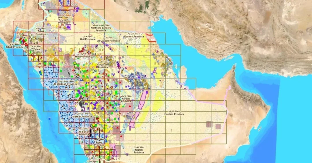
The Saudi Geological Survey (SGS) will launch a new package of specialized geological data on Friday, including 37 new airborne geophysical maps, as part of its ongoing efforts to strengthen the mining sector’s role as a strategic economic driver aligned with the goals of Saudi Vision 2030. The announcement, released via the Saudi Press Agency, marks a significant expansion of the National Geological Database, bringing the total number of published maps to 201. These maps will serve as keys to mineral wealth and a roadmap toward targeted investments that contribute to building a diverse economic future.
Have you ever wondered how a nation unlocks the treasures hidden beneath its soil? For the Kingdom of Saudi Arabia, the answer lies in meticulous data collection and strategic dissemination. The new airborne geophysical maps will be accessible through the National Geological Database platform, providing investors, researchers, and policymakers with precise, high-resolution data on the Kingdom’s mineral resources. This initiative underscores Saudi Arabia’s commitment to transparency and modernization in the mining sector, a cornerstone of its economic diversification strategy. By making this data publicly available, the SGS is not only facilitating exploration but also inviting global participation in the Kingdom’s mining renaissance.
Context and Background
Why is the release of geological data such a pivotal moment for Saudi Arabia’s economic trajectory? The Kingdom has long recognized that its vast mineral wealth—estimated at over $2.5 trillion—remains largely untapped. Under Vision 2030, Saudi Arabia aims to transform mining into the third pillar of its industrial economy, alongside oil and petrochemicals. The Saudi Geological Survey, established in 1999, has been at the forefront of this effort, systematically mapping the Arabian Shield, a mineral-rich region covering much of the western part of the country.
The National Geological Database, launched in 2021, represents a digital leap forward, consolidating decades of geological surveys into an accessible online platform. The addition of 37 new airborne geophysical maps is a continuation of this mission. Airborne geophysical surveys use aircraft equipped with sensors to measure magnetic, radiometric, and gravitational variations in the Earth’s crust, revealing subsurface structures and mineral deposits. These maps are indispensable tools for identifying prospective areas for gold, copper, phosphate, and rare earth elements—critical for both traditional and green technologies.
Previous releases have already attracted significant interest from international mining companies. The SGS’s efforts align with the Ministry of Industry and Mineral Resources’ goal to increase mining’s contribution to GDP from $17 billion to $64 billion by 2030. By expanding the database, Saudi Arabia is not only showcasing its geological richness but also signaling its readiness to partner with global investors. The timing is strategic: as the world transitions to clean energy, demand for minerals like lithium, nickel, and cobalt is soaring, and Saudi Arabia is positioning itself as a reliable supplier.
Key Details of the New Data Package
What exactly does this new data package entail, and how will it be utilized? The 37 new airborne geophysical maps cover various regions of the Arabian Shield, with a focus on areas previously underexplored. Each map provides detailed information on magnetic anomalies, radioactive elements, and density variations, which geologists use to infer the presence of mineralized zones. The data is processed using advanced algorithms and integrated with existing geological, geochemical, and topographical data to create a comprehensive exploration toolkit.
The National Geological Database platform will host these maps, offering user-friendly interfaces for querying and downloading. According to the SGS, the platform is designed to cater to a wide range of users, from junior exploration companies to academic researchers. The release also includes metadata and interpretive reports, ensuring that even non-specialists can understand the significance of the findings. This level of detail reduces exploration risk and accelerates the discovery-to-production timeline, a critical factor in attracting investment.
Moreover, the SGS has emphasized that the data will be regularly updated as new surveys are completed. The goal is to create a living database that evolves with technological advancements and exploration outcomes. This dynamic approach ensures that Saudi Arabia remains at the cutting edge of mineral exploration, providing a competitive edge in the global mining landscape. The launch event on Friday will feature presentations by SGS officials and possibly representatives from the Ministry of Industry and Mineral Resources, highlighting the collaborative effort behind this initiative.
International and Regional Impact
How will this data release influence Saudi Arabia’s standing in the global mining community? The availability of high-quality, open-access geological data is a key factor for international mining companies when deciding where to invest. By expanding its database, Saudi Arabia is sending a clear message: it is open for business and committed to reducing barriers to entry. This is particularly important as competition for mining investment intensifies among jurisdictions in Africa, Latin America, and Australia.
Regionally, the data could spur cross-border collaboration. The Arabian Shield extends into neighboring countries like Egypt, Sudan, and Yemen, and shared geological formations mean that insights from Saudi data can inform exploration in these areas. However, Saudi Arabia’s advanced data infrastructure gives it a first-mover advantage. The Kingdom has also been actively promoting its mining sector through international forums, such as the Future Minerals Forum in Riyadh, which brings together stakeholders from across the globe. The new maps will likely be a topic of discussion at such events, further elevating Saudi Arabia’s profile as a mining destination.
Furthermore, the data supports the Kingdom’s broader geopolitical strategy of economic diversification and regional stability. By fostering a robust mining sector, Saudi Arabia can create jobs, develop remote regions, and reduce its dependence on oil. This aligns with its role as a responsible global energy and resource provider, especially as the world seeks secure and sustainable supply chains for critical minerals.
Economic and Strategic Significance
What makes this data package a game-changer for Saudi Arabia’s economy? Mining is a capital-intensive industry with long lead times, and access to reliable data is the first step in attracting the billions of dollars needed for exploration and development. The SGS’s initiative lowers the upfront risk for investors by providing them with a detailed picture of where minerals are likely to be found. This can lead to faster discoveries, which in turn generate royalties, taxes, and employment opportunities.
The strategic significance extends beyond economics. Minerals are essential for the global energy transition, and Saudi Arabia aims to be a key player in supplying the materials needed for electric vehicles, solar panels, and wind turbines. The new maps include data on rare earth elements, which are critical for high-tech applications and currently dominated by a few countries. By unlocking its own resources, Saudi Arabia can contribute to diversifying global supply chains, enhancing energy security for itself and its allies.
Additionally, the data supports the growth of downstream industries. Once mineral deposits are identified and mined, they can feed into local manufacturing, creating value-added products and further diversifying the economy. The SGS’s work is thus a catalyst for the entire mining value chain, from exploration to refining to manufacturing. This holistic approach is central to Vision 2030’s goal of building a sustainable and diversified economy.
Vision 2030 Alignment
How does this data release fit into the broader vision for Saudi Arabia’s future? Vision 2030, launched in 2016 by Crown Prince Mohammed bin Salman, sets out a comprehensive plan to transform the Kingdom’s economy and society. Mining is explicitly identified as a key sector for growth, with targets to increase its contribution to GDP and create thousands of jobs. The SGS’s new data package directly supports these objectives by providing the foundational information needed to attract investment and accelerate project development.
Moreover, the initiative reflects the Vision’s emphasis on transparency, innovation, and global engagement. By making geological data publicly available, Saudi Arabia is embracing open data principles and fostering a knowledge-based economy. The use of advanced airborne geophysical surveys demonstrates the Kingdom’s commitment to leveraging technology for economic gain. As Saudi Arabia continues to roll out new data and attract international partners, it is not only unlocking its mineral wealth but also building a legacy of sustainable development for future generations. The launch of these 37 maps is another step on the path to realizing the Vision’s ambitious goals, reinforcing the Kingdom’s position as a global leader in mining and beyond.
20 Questions
Q1. What is the Saudi Geological Survey launching on Friday?
A1. The Saudi Geological Survey will launch a new package of specialized geological data, including 37 new airborne geophysical maps, as part of efforts to strengthen the mining sector and align with Saudi Vision 2030.
Q2. How many new maps are being added to the National Geological Database?
A2. 37 new airborne geophysical maps will be added, bringing the total number of published maps to 201, all accessible through the National Geological Database platform.
Q3. What is the purpose of these airborne geophysical maps?
A3. They serve as keys to mineral wealth and a roadmap toward targeted investments, helping identify mineral deposits and contributing to a diverse economic future for Saudi Arabia.
Q4. What is the National Geological Database?
A4. It is a digital platform launched by the Saudi Geological Survey that consolidates geological data, providing access to maps and information for investors, researchers, and policymakers.
Q5. How does this initiative support Saudi Vision 2030?
A5. It supports Vision 2030 by enhancing the mining sector’s role as a strategic economic driver, attracting investment, creating jobs, and diversifying the economy away from oil dependence.
Q6. What types of minerals can be identified using these maps?
A6. The maps help identify minerals such as gold, copper, phosphate, and rare earth elements, which are critical for traditional and green technologies.
Q7. Who will benefit from the release of this data?
A7. International mining companies, researchers, investors, and policymakers will benefit by gaining access to high-quality data that reduces exploration risk and informs investment decisions.
Q8. How does the Saudi Geological Survey collect airborne geophysical data?
A8. Aircraft equipped with sensors measure magnetic, radiometric, and gravitational variations in the Earth’s crust, revealing subsurface structures and potential mineral deposits.
Q9. What is the significance of the Arabian Shield in this context?
A9. The Arabian Shield is a mineral-rich region covering much of western Saudi Arabia, and the new maps focus on underexplored areas within it, highlighting its vast mineral potential.
Q10. How will this data attract international investment?
A10. By providing open-access, detailed geological data, Saudi Arabia lowers exploration risks and demonstrates its commitment to transparency, making it more attractive to global mining investors.
Q11. What is the expected economic impact of increased mining activity?
A11. It is expected to boost GDP, create jobs, develop remote regions, and generate royalties and taxes, contributing to a diversified and sustainable economy.
Q12. How does this align with global trends in mining?
A12. It aligns with the global shift toward clean energy, which increases demand for critical minerals, positioning Saudi Arabia as a reliable supplier in the international market.
Q13. Will the data be regularly updated?
A13. Yes, the Saudi Geological Survey plans to regularly update the database with new surveys and findings, ensuring it remains a dynamic and valuable resource for users.
Q14. What role does the Ministry of Industry and Mineral Resources play?
A14. The ministry supports the Saudi Geological Survey’s efforts and aims to increase mining’s contribution to GDP from $17 billion to $64 billion by 2030, aligning with Vision 2030.
Q15. How can interested parties access the new maps?
A15. The maps will be available through the National Geological Database platform, which offers user-friendly interfaces for querying and downloading data.
Q16. What is the significance of the total number of maps reaching 201?
A16. It reflects the comprehensive nature of Saudi Arabia’s geological surveying efforts, providing a robust foundation for mineral exploration and investment.
Q17. How does this initiative promote sustainability?
A17. By facilitating the discovery of minerals needed for renewable energy technologies, it supports the global transition to a low-carbon economy and sustainable development.
Q18. What other initiatives support Saudi Arabia’s mining sector?
A18. The Future Minerals Forum in Riyadh and various incentives for investors are key initiatives that complement the data release and promote the mining sector.
Q19. How does this data release enhance Saudi Arabia’s global standing?
A19. It positions the Kingdom as a leader in mining transparency and innovation, attracting international partnerships and showcasing its commitment to economic diversification.
Q20. What is the next step after the launch of these maps?
A20. The Saudi Geological Survey will continue to conduct surveys, update the database, and engage with stakeholders to facilitate exploration and development, driving forward Vision 2030 goals.
Reader Feedback
We value your thoughts. Please share your feedback on this article.
Your feedback helps us improve our coverage.
Related articles
 ICD Provides €15 Million Financing to CCA-Bank in Cameroon
 Saudi Cluster 2 Airports Sees 4.5% Flight Growth in Q1 2025
 Saudi Arabia Shares Taif Rose Expertise with Oman
 Saudi Arabia Joins 17th European Economic Congress
 U.S.-Saudi Business Council Hosts High-Level Investment Event
 Saudi Dairy Forum Concludes with Deals Exceeding SAR150 Million