


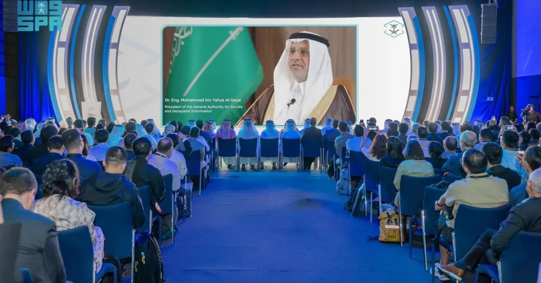
Saudi Arabia’s General Authority for Survey and Geospatial Information (GEOSA) has taken a leading role at the Geospatial Week GSW2025 conference in Dubai, reinforcing the Kingdom’s growing international standing in surveying, geospatial information, and imaging. The event, organized by the International Society for Photogrammetry and Remote Sensing (ISPRS) in collaboration with the Mohammed bin Rashid Space Center, opened on April 7 and runs through April 11, bringing together government agencies, research institutions, and technology firms from across the world.
GEOSA President and ISPRS regional representative for Arab states Dr. Eng. Mohammed bin Yahya Al-Sayel delivered a keynote address at the opening session, outlining the Kingdom’s strategic vision for the sector and its ambition to shape the future of geospatial sciences globally. His remarks underscored how Saudi Arabia, through GEOSA, is positioning geospatial information as a foundational pillar of digital transformation, economic growth, and evidence-based policymaking — priorities that align directly with Saudi Vision 2030. The Dubai gathering marks the second consecutive time the Arab region has hosted the ISPRS flagship event, following Egypt in 2023, a fact that Al-Sayel said reflects the rising influence of Arab nations in the global geospatial arena. As the world increasingly relies on precise location data for urban planning, disaster response, and sustainable development, is Saudi Arabia’s leadership in this field a sign of things to come for the region?
Context and Background
How did Saudi Arabia emerge as a central player in the global geospatial community? The answer lies in a decade of sustained institutional development, strategic investment, and international engagement led by GEOSA, the official body responsible for regulating the surveying, geospatial information, and imaging sector in the Kingdom. Established to oversee a sector once fragmented across multiple agencies, GEOSA has consolidated national efforts to build a robust geospatial infrastructure that serves government, business, and society. Its mandate extends beyond regulation to include innovation, capacity building, and international cooperation — a holistic approach that has earned recognition from the United Nations and other multilateral bodies.
The Geospatial Week GSW2025 conference, held in Dubai from April 7 to 11, is a premier global forum for photogrammetry and remote sensing professionals. Organized by ISPRS in collaboration with the Mohammed bin Rashid Space Center, the event features technical sessions, exhibitions, and networking opportunities focused on the latest advances in Earth observation, mapping, and geospatial intelligence. GEOSA’s participation as a main sponsor — with a dedicated pavilion, panel discussions, and scientific papers — signals the Kingdom’s intent not only to participate but to lead. Al-Sayel’s keynote highlighted that the Arab region’s hosting of this event for the second consecutive time reflects the growing role of Arab countries in the global geospatial arena, a shift that Saudi Arabia has helped accelerate through its own investments and diplomatic efforts.
GEOSA’s rise is inseparable from Saudi Vision 2030, the national transformation plan launched by Crown Prince Mohammed bin Salman. The vision calls for a diversified economy, smart cities, and world-class public services — all of which depend on accurate, accessible, and secure geospatial data. By building a national geospatial infrastructure, GEOSA is laying the groundwork for sectors as diverse as urban planning, transportation, agriculture, energy, and environmental management. The authority’s work is not merely technical; it is strategic, enabling the Kingdom to make data-driven decisions that enhance quality of life and economic competitiveness.
Key Details
What exactly did Al-Sayel announce in Dubai, and why does it matter? In his keynote, the GEOSA president emphasized that the Kingdom, through GEOSA, continues its pursuit of international leadership at the regional and global levels. He noted that GEOSA plays a pivotal role in leading geospatial transformation across the Arab world, enhancing the role of geospatial information to support and enable various development sectors, and ensuring that it becomes an essential component of digital transformation and economic growth strategies. This is achieved in collaboration with international organizations and relevant research institutions to promote knowledge and stimulate innovation.
A centerpiece of GEOSA’s strategy is the National Geospatial Platform, designed to integrate geospatial data and maximize its benefits by providing a single, secure, and easy-to-access source based on best publishing practices and standards. The platform is intended to serve as the authoritative reference for geospatial information in the Kingdom, enabling government agencies, private companies, and researchers to access high-quality data for planning and decision-making. Alongside the platform, GEOSA has launched the National Geospatial Academy, a knowledge hub and global platform for specialized education and training to build and empower geospatial human capabilities. These initiatives reflect a comprehensive approach that combines infrastructure, data, and talent — the three pillars of a sustainable geospatial ecosystem.
Al-Sayel also highlighted a major diplomatic achievement: the United Nations’ final approval for Saudi Arabia to host the UN Global Center of Excellence for the Future Ecosystem for Geospatial Information, with Riyadh as its headquarters. This center will serve as a global hub for research, innovation, and capacity building, further cementing the Kingdom’s role as a leader in the field. In addition, the Kingdom is seeking to host the ISPRS 2030 conference under the theme “Mapping the Future: Innovations in Geospatial Sciences.” If successful, Saudi Arabia would become the first Arab country to host the ISPRS conference, delivering a historic milestone for the global geospatial community. The proposed event would include global hackathons and major competitions aimed at enhancing the role of geospatial information in developing smart solutions, addressing modern-day challenges, promoting decision-making based on geospatial intelligence, supporting smart urban planning, showcasing the latest geospatial technologies and applications, raising geospatial awareness, and empowering human capabilities in the geospatial field.
International and Regional Impact
How does Saudi Arabia’s geospatial leadership resonate beyond its borders? The Kingdom’s growing influence in the geospatial arena has significant implications for the Arab world and the broader international community. By leading geospatial transformation across the region, GEOSA is helping to harmonize standards, share best practices, and build capacity in countries that are at earlier stages of developing their own geospatial infrastructures. This collaborative approach fosters regional integration and supports the achievement of the UN Sustainable Development Goals, particularly those related to sustainable cities, climate action, and innovation.
The establishment of the UN Global Center of Excellence in Riyadh will further amplify Saudi Arabia’s global role. The center is expected to attract researchers, policymakers, and industry leaders from around the world, creating a vibrant ecosystem for geospatial innovation. It will also provide a platform for international cooperation on pressing challenges such as climate change, disaster risk reduction, and food security — all of which rely heavily on geospatial data and analysis. By hosting this center, Saudi Arabia is not only enhancing its own capabilities but also contributing to global public goods. Is this the kind of leadership the world needs in an era of complex, data-driven challenges?
Regionally, the back-to-back hosting of the ISPRS Geospatial Week in Egypt (2023) and the UAE (2025) demonstrates a broader trend: the Middle East is becoming a hub for geospatial science and technology. Saudi Arabia’s active participation and sponsorship of GSW2025 reinforce this trend and position the Kingdom as a linchpin of the region’s geospatial ecosystem. The Kingdom’s bid to host ISPRS 2030, if successful, would cap this trajectory and bring the world’s premier geospatial conference to Riyadh for the first time.
Economic and Strategic Significance
Why should businesses and investors pay attention to geospatial information? Geospatial data is increasingly recognized as a critical economic asset, underpinning industries from construction and logistics to agriculture and renewable energy. According to the World Economic Forum, the global geospatial market is projected to grow substantially in the coming years, driven by demand for location intelligence, autonomous systems, and smart city solutions. Saudi Arabia’s investment in its national geospatial infrastructure is therefore not just a public service — it is an economic development strategy. By preparing the sector for investment and stimulating its growth, GEOSA aims to attract private capital, foster startups, and create high-skilled jobs for Saudi youth.
The National Geospatial Platform and the National Geospatial Academy are key enablers of this economic vision. The platform reduces barriers to data access, making it easier for entrepreneurs and small businesses to develop innovative applications. The academy ensures a steady pipeline of talent, equipping Saudis with the skills needed to compete in a global market. Together, these initiatives support the diversification of the Saudi economy away from oil, a core objective of Vision 2030. Moreover, the Kingdom’s pursuit of international leadership in geospatial sciences enhances its soft power and diplomatic influence, reinforcing its role as a bridge between the developed and developing worlds.
Strategically, geospatial information is vital for national security, border management, and disaster preparedness. Accurate maps and real-time data are essential for responding to natural disasters, managing resources, and protecting critical infrastructure. By building a robust geospatial infrastructure, Saudi Arabia is strengthening its resilience and ensuring that decision-makers have the information they need to act swiftly and effectively. This is particularly important as the Kingdom hosts major events and pursues ambitious mega-projects like NEOM, which require precise geospatial planning and monitoring.
Vision 2030 Alignment
How does GEOSA’s work connect to the broader goals of Saudi Vision 2030? The vision, launched in 2016, aims to transform Saudi Arabia into a diversified, innovative, and globally engaged economy. Geospatial information is a foundational enabler of this transformation, supporting everything from smart city development to environmental sustainability. GEOSA’s efforts to build a national geospatial infrastructure, launch the National Geospatial Platform, and establish the National Geospatial Academy are directly aligned with Vision 2030’s objectives of enhancing government efficiency, fostering economic growth, and empowering citizens. By integrating geospatial data into digital transformation strategies, the Kingdom is creating a more transparent, responsive, and data-driven public sector.
Furthermore, Saudi Arabia’s leadership in the global geospatial arena — evidenced by the UN Global Center of Excellence and the ISPRS 2030 bid — reflects the vision’s emphasis on international cooperation and soft power. The Kingdom is not only investing domestically but also contributing to global knowledge and innovation, in line with its G20 role and its ambition to be a leader in the Fourth Industrial Revolution. As Al-Sayel’s keynote made clear, GEOSA is committed to ensuring that geospatial information becomes an essential component of digital transformation and economic growth strategies, both in Saudi Arabia and around the world. With the Kingdom’s track record of delivering on ambitious initiatives, its geospatial leadership is poised to deliver lasting benefits for the region and the world. Is there any doubt that Saudi Arabia is mapping the future?
20 Questions
Q1. What is Geospatial Week GSW2025?
A1. Geospatial Week GSW2025 is a global conference organized by the International Society for Photogrammetry and Remote Sensing (ISPRS) in collaboration with the Mohammed bin Rashid Space Center, held in Dubai from April 7 to 11, 2025. It focuses on photogrammetry, remote sensing, and geospatial information.
Q2. Who represented Saudi Arabia at the conference?
A2. Dr. Eng. Mohammed bin Yahya Al-Sayel, President of the General Authority for Survey and Geospatial Information (GEOSA) and ISPRS regional representative for Arab states, delivered a keynote speech at the opening session.
Q3. What did Al-Sayel highlight about Arab region hosting?
A3. He noted that the Arab region hosting this prominent event for the second consecutive time—after Egypt in 2023—reflects the growing role of Arab countries in the global geospatial arena.
Q4. What is GEOSA’s role in Saudi Arabia?
A4. GEOSA is the official body responsible for regulating the surveying, geospatial information, and imaging sector in the Kingdom. It leads geospatial transformation and supports various development sectors.
Q5. What is the National Geospatial Platform?
A5. It is a platform aimed at integrating geospatial data and maximizing its benefits by providing a single, secure, and easy-to-access source based on best publishing practices and standards.
Q6. What is the National Geospatial Academy?
A6. The academy is a knowledge hub and global platform for specialized education and training to build and empower geospatial human capabilities in Saudi Arabia and beyond.
Q7. What UN recognition did Saudi Arabia receive?
A7. The United Nations gave final approval for Saudi Arabia to host the UN Global Center of Excellence for the Future Ecosystem for Geospatial Information, with Riyadh as its headquarters.
Q8. What conference is Saudi Arabia seeking to host?
A8. Saudi Arabia is seeking to host the ISPRS 2030 conference under the theme “Mapping the Future: Innovations in Geospatial Sciences,” which would be the first time an Arab country hosts it.
Q9. How is GEOSA participating in GSW2025?
A9. GEOSA is participating as a main sponsor, showcasing its local and international experiences through a dedicated pavilion, several panel discussions, and scientific papers.
Q10. What are the goals of the proposed ISPRS 2030 conference?
A10. It aims to include global hackathons and competitions to enhance geospatial information’s role in smart solutions, decision-making, smart urban planning, and empowering human capabilities.
Q11. How does GEOSA support Vision 2030?
A11. GEOSA builds national geospatial infrastructure to prepare the sector for investment, stimulate growth, and integrate geospatial data into digital transformation and economic growth strategies, aligning with Vision 2030 goals.
Q12. What is the significance of the UN Global Center of Excellence?
A12. It will serve as a global hub for research, innovation, and capacity building in geospatial information, reinforcing Saudi Arabia’s leadership and contributing to global knowledge.
Q13. How does geospatial information support economic growth?
A13. It underpins industries like construction, logistics, agriculture, and renewable energy, and is a critical asset for location intelligence, autonomous systems, and smart city solutions, attracting investment and creating jobs.
Q14. What is the role of the National Geospatial Platform in investment?
A14. By providing easy access to high-quality geospatial data, the platform reduces barriers for entrepreneurs and businesses, fostering innovation and attracting private capital to the sector.
Q15. How does GEOSA collaborate internationally?
A15. GEOSA collaborates with international organizations and research institutions to promote knowledge, stimulate innovation, and lead geospatial transformation across the Arab world and globally.
Q16. What are the benefits of hosting ISPRS 2030 in Saudi Arabia?
A16. It would be a historic milestone, opening new horizons for geospatial sciences, showcasing technologies, raising awareness, and empowering human capabilities, while positioning Saudi Arabia as a global leader.
Q17. How does geospatial data support smart urban planning?
A17. It provides accurate, real-time information for planning infrastructure, transportation, and services, enabling data-driven decisions that enhance quality of life and sustainability in cities.
Q18. What is the significance of the Arab region hosting GSW twice?
A18. It demonstrates the growing influence and capacity of Arab countries in the global geospatial arena, highlighting their contributions to science and technology.
Q19. How does GEOSA empower human capabilities?
A19. Through the National Geospatial Academy, GEOSA offers specialized education and training, building a skilled workforce that can drive innovation and support the sector’s growth.
Q20. What is the future outlook for Saudi geospatial leadership?
A20. With ongoing initiatives, UN recognition, and a bid for ISPRS 2030, Saudi Arabia is poised to remain at the forefront of geospatial innovation, contributing to global challenges and Vision 2030 success.
Reader Feedback
We value your thoughts. Please share your feedback on this article.
Your feedback helps us improve our coverage.
Related articles
 Al-Khobar Advances 38 Places in IMD Smart City Index 2025
 Saudi Electronic University Launches First Sports Tech Accelerator
 CST Leads Global Satellite Standards Talks at Space Symposium
 GEOSA, Singapore Land Authority Launch Geospatial Project Achievements
 Saudi Arabia Among Global AI Leaders on Stanford AI Index 2025
 Saudi Arabia Was a Green Oasis 8 Million Years Ago, Study Reveals