


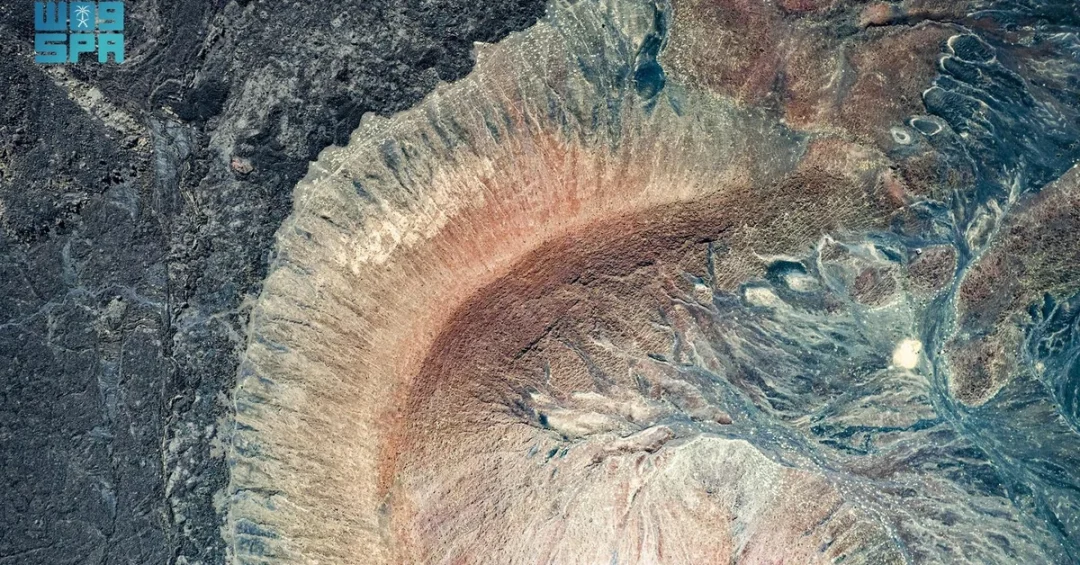
Harrat Lunayyir, the vast volcanic lava field east of Umluj Governorate in northwestern Saudi Arabia, is being showcased as one of the Kingdom’s most remarkable natural landmarks, with official Saudi imagery confirming that its ancient volcanic cones and hills have retained their original form across millennia. Known locally as Harrat Al-Shaqa, the site forms part of the Tabuk region’s diverse terrain and stands as a striking example of the geological heritage that Saudi Arabia is opening to the world under Vision 2030. Information released via the Saudi Press Agency (SPA) describes the lava field as an open-air natural museum, with volcanic formations dating back to the early Tertiary Period. Have you ever imagined walking across a landscape shaped by the Earth’s deepest forces, preserved almost exactly as nature left it?
The Saudi Press Agency documented the site with a series of photographs capturing its massive volcanic hills and cones, noting that these formations have remarkably retained their original form over time. Lava covers approximately 70 percent of Harrat Lunayyir’s total area, while marshes account for about 5 percent of the land, particularly in coastal areas bordering the Red Sea. The combination of dark volcanic rock, scattered cones, and coastal wetlands creates a landscape that is rare not only in Saudi Arabia but across the wider Arabian Peninsula. For international readers, Harrat Lunayyir offers a window into the geological history of the region and into the Kingdom’s growing portfolio of natural tourism destinations beyond its celebrated heritage cities and Red Sea coastline.
Context and Background
What makes a lava field in northwestern Saudi Arabia worthy of global attention? Harrat Lunayyir sits within the Tabuk region, an area long recognized for its diverse terrain and its status as a major tourist destination in the northwest of the Kingdom. The region combines mountain ranges, desert expanses, coastal waters, and volcanic geology within a relatively compact area, giving it a distinctive position in Saudi Arabia’s tourism map. The lava field is located east of Umluj Governorate, a coastal community on the Red Sea that has become increasingly known for its pristine islands and clear waters. Together, these features position Tabuk as a destination where natural history and modern tourism infrastructure are converging.
Geologically, Harrat Lunayyir is one of the Kingdom’s most prominent volcanic fields. Its formations date back to the early Tertiary Period, placing them among the older geological features in the region. Over vast spans of time, successive eruptions built the cones and hills that define the site today. The fact that so much of the original structure remains intact is significant for researchers and visitors alike. The Saudi Press Agency’s documentation emphasizes this preservation, describing the volcanic hills and cones as adding to the site’s unique aesthetic appeal. For a non-Saudi audience, the site represents a category of tourism — geotourism — that is still emerging in the Arabian Peninsula but holds considerable potential.
Local knowledge adds another layer to the story. The name Harrat Al-Shaqa reflects the site’s deep roots in the surrounding community, where generations have lived alongside these volcanic formations. This blend of scientific value and local heritage makes Harrat Lunayyir more than a geological curiosity; it is part of the cultural and natural fabric of Tabuk. As Saudi Arabia continues to develop its tourism sector, such sites illustrate how natural wonders can be integrated into a broader visitor experience that includes coastal recreation, heritage exploration, and desert adventure.
Key Details
What exactly does Harrat Lunayyir contain, and why does its composition matter? According to official information, lava covers approximately 70 percent of the field’s area, making it one of the most extensive volcanic landscapes in the Kingdom. Marshes constitute about 5 percent of the land, concentrated particularly in coastal regions bordering the Red Sea. This unusual pairing of volcanic rock and wetland habitat creates ecological niches that are uncommon in arid environments. The massive volcanic hills and cones, captured in Saudi Press Agency photographs, remain visibly defined, with shapes that have survived erosion and time to a remarkable degree.
The site’s description as an open-air natural museum is not merely rhetorical. It reflects the educational and scientific value of a landscape where volcanic processes can be observed in structures that date back to the early Tertiary Period. For geology students, researchers, and curious travelers, Harrat Lunayyir offers direct evidence of the forces that shaped the Arabian Peninsula. The Saudi Press Agency’s images highlight the aesthetic dimension as well, showing formations that are dramatic in scale and texture. This combination of scientific and visual appeal is central to the site’s potential as a destination.
Accessibility and context are also part of the story. Located east of Umluj, the lava field can be incorporated into itineraries that already include the Red Sea coast, where development projects are expanding hospitality options. The Tabuk region as a whole is being positioned as a year-round destination, with cooler highland areas, coastal resorts, and desert landscapes within reach of each other. Harrat Lunayyir adds a distinct geological chapter to that offering, one that complements rather than duplicates the Kingdom’s other natural attractions. For visitors seeking something beyond traditional sightseeing, the site promises an encounter with deep time and raw natural power.
International and Regional Impact
How does a volcanic field in northwestern Saudi Arabia connect to global travel trends? Interest in geotourism, adventure travel, and natural heritage has grown steadily among international travelers seeking authentic and educational experiences. Harrat Lunayyir fits this demand precisely, offering a landscape that is visually striking and scientifically significant. For regional audiences in the Gulf and wider Middle East, the site also represents a nearby destination that combines discovery with comfort, given the ongoing expansion of Saudi tourism infrastructure. The Kingdom’s efforts to diversify visitor sources align with these trends, and unique natural sites strengthen its competitive position.
Regionally, volcanic fields are found in several parts of the Arabian Peninsula, but Harrat Lunayyir’s scale, preservation, and coastal proximity set it apart. Its location near Umluj places it within a broader Red Sea tourism corridor that includes islands, coral reefs, and emerging resorts. This geographic advantage allows the site to be marketed as part of a multi-experience journey rather than a standalone stop. Internationally, the documentation of the site by the Saudi Press Agency contributes to a growing body of official content that presents Saudi Arabia’s natural heritage to global audiences. Such exposure supports the Kingdom’s goal of attracting visitors who value nature, science, and culture alongside luxury and entertainment.
Economic and Strategic Significance
What economic value can a preserved volcanic landscape bring to the Kingdom? Tourism is a central pillar of Saudi Arabia’s economic diversification strategy, and natural attractions like Harrat Lunayyir contribute to a broader portfolio that reduces reliance on any single type of visitor experience. Geotourism can support local employment in guiding, hospitality, transportation, and interpretation services. It can also extend the length of visitor stays in the Tabuk region, generating spending that benefits coastal and inland communities alike. The site’s proximity to Umluj means it can be integrated into existing and planned tourism routes, maximizing the return on infrastructure investments.
Strategically, the preservation of Harrat Lunayyir reflects a wider commitment to protecting natural heritage while developing it responsibly. Official documentation of the site helps establish a baseline of information that can inform conservation and visitor management. For international partners and investors, the presence of well-documented natural assets signals a mature approach to tourism development. The Kingdom’s Vision 2030 framework emphasizes quality of life, environmental stewardship, and economic opportunity, and sites such as this one demonstrate how those goals can be advanced together. The lava field is therefore not only a wonder to behold but also a component of a long-term national strategy.
Vision 2030 Alignment
How does Harrat Lunayyir fit into the Kingdom’s long-term vision? Vision 2030 seeks to diversify Saudi Arabia’s economy, enhance quality of life for citizens and residents, and position the country as a leading global destination. Natural landmarks like Harrat Lunayyir support all three objectives. They attract visitors, create economic opportunities, and enrich the cultural and recreational landscape for local communities. The Tabuk region, with its combination of coast, mountains, and volcanic terrain, exemplifies the diversity that Vision 2030 aims to showcase. By documenting and promoting such sites through official channels, Saudi Arabia is building the awareness needed to draw international travelers.
The site also aligns with the vision’s emphasis on sustainability and responsible development. Preserving volcanic formations that date back to the early Tertiary Period is an act of stewardship that benefits future generations. It also reinforces the Kingdom’s broader environmental goals, which include protecting land and marine ecosystems. As Saudi Arabia continues to open new destinations, Harrat Lunayyir stands as a reminder that the country’s appeal extends beyond its modern cities and heritage sites to the raw, ancient beauty of its natural world. For readers around the globe, it is an invitation to discover a landscape where the Earth’s history is written in stone, and where the future is being built with care.
20 Questions
Q1. What is Harrat Lunayyir?
A1. Harrat Lunayyir, also known locally as Harrat Al-Shaqa, is a prominent volcanic lava field located east of Umluj Governorate in the Tabuk region of northwestern Saudi Arabia. It is recognized for its extensive lava coverage and well-preserved volcanic formations.
Q2. Where is Harrat Lunayyir located?
A2. It is located east of Umluj Governorate in the Tabuk region of northwestern Saudi Arabia. The site lies near the Red Sea coast, which gives it a distinctive combination of volcanic terrain and coastal marshland.
Q3. Why is Harrat Lunayyir considered a volcanic wonderland?
A3. It is considered a volcanic wonderland because lava covers approximately 70 percent of its area, and it features massive volcanic hills and cones that have retained their original form over time, creating a rare and visually striking landscape.
Q4. What percentage of Harrat Lunayyir is covered by lava?
A4. According to official information, lava covers approximately 70 percent of Harrat Lunayyir’s total area. This makes it one of the most prominent volcanic fields in the Kingdom of Saudi Arabia.
Q5. What other natural features are found at the site?
A5. Marshes constitute about 5 percent of the land, particularly in coastal regions bordering the Red Sea. The rest of the area consists of volcanic rock, hills, cones, and associated terrain typical of a lava field.
Q6. How old are the volcanic formations at Harrat Lunayyir?
A6. The volcanic formations date back to the early Tertiary Period. This geological age places them among the older natural features in the region and adds significant scientific value to the site.
Q7. Why is Harrat Lunayyir described as an open-air natural museum?
A7. It is described this way because it showcases volcanic formations in their natural setting, allowing visitors and researchers to observe geological processes and structures that date back millions of years without entering an indoor facility.
Q8. Who documented the volcanic formations at Harrat Lunayyir?
A8. The Saudi Press Agency documented the site by capturing stunning images of its volcanic formations. These official photographs highlight the scale, texture, and preservation of the hills and cones.
Q9. What makes the preservation of these formations remarkable?
A9. The formations have remarkably retained their original form over time, despite exposure to erosion and natural elements. This level of preservation is rare and contributes to the site’s scientific and aesthetic appeal.
Q10. How does Harrat Lunayyir contribute to tourism in Tabuk?
A10. It adds a unique geological attraction to the Tabuk region’s diverse offerings, which already include coastal areas, mountains, and desert landscapes. This helps position Tabuk as a major tourist destination in northwestern Saudi Arabia.
Q11. Is Harrat Lunayyir important for scientific research?
A11. Yes. Its formations dating to the early Tertiary Period provide valuable insights into the geological history of the Arabian Peninsula. Researchers can study volcanic processes and landscape evolution in a well-preserved natural environment.
Q12. What is the local name for Harrat Lunayyir?
A12. The local name is Harrat Al-Shaqa. This name reflects the site’s deep roots in the surrounding community and its recognition as a distinctive landmark in the Tabuk region.
Q13. How does Harrat Lunayyir support Vision 2030?
A13. It supports Vision 2030 by contributing to tourism diversification, economic opportunity, and quality of life. Natural landmarks like this attract visitors and showcase Saudi Arabia’s environmental and geological heritage to the world.
Q14. What types of travelers would enjoy visiting Harrat Lunayyir?
A14. Adventure travelers, geology enthusiasts, photographers, and nature lovers would all find the site compelling. Its dramatic volcanic terrain and coastal marshlands offer varied experiences within a single destination.
Q15. Are there marshes at Harrat Lunayyir?
A15. Yes. Marshes make up about 5 percent of the land, particularly in coastal regions bordering the Red Sea. This creates an unusual contrast between volcanic rock and wetland habitat.
Q16. What is the significance of the volcanic cones and hills?
A16. The volcanic cones and hills are significant because they add to the site’s unique aesthetic appeal and provide clear examples of volcanic structures. Their preservation allows visitors to appreciate the scale of past eruptions.
Q17. How does Harrat Lunayyir compare to other Saudi natural sites?
A17. It stands out as one of the Kingdom’s most prominent volcanic fields, with extensive lava coverage and well-preserved formations. Its coastal proximity near Umluj adds a dimension not found at many inland geological sites.
Q18. What role does the Saudi Press Agency play in promoting such sites?
A18. The Saudi Press Agency documents and shares official information and imagery of natural landmarks, helping to raise awareness among international audiences and support the Kingdom’s tourism and heritage goals.
Q19. Can visitors access Harrat Lunayyir easily?
A19. The site is located in the Tabuk region near Umluj, which is increasingly accessible through expanding tourism infrastructure. Visitors can include it in broader itineraries that feature the Red Sea coast and surrounding landscapes.
Q20. Why should international audiences pay attention to Harrat Lunayyir?
A20. International audiences should pay attention because it represents a rare geological wonder that is being responsibly documented and opened to the world. It reflects Saudi Arabia’s broader efforts to share its natural heritage under Vision 2030.
Reader Feedback
We value your thoughts. Please share your feedback on this article.
Your feedback helps us improve our coverage.
Related articles
 TDF at World Travel Market Reinforces Saudi Tourism Hub
 Saudi ACP Highlights 12 New Airlines at Hong Kong Expo
 TDF Drives Tourism Innovation at Biban24 with Key Agreements
 AlUla Hot Air Balloon Safaris Offer Timeless Views
 AlUla’s Hegra After Dark: Where History Meets Innovation
 AlUla Dates Season 2024 Concludes with 30% Sales Surge