


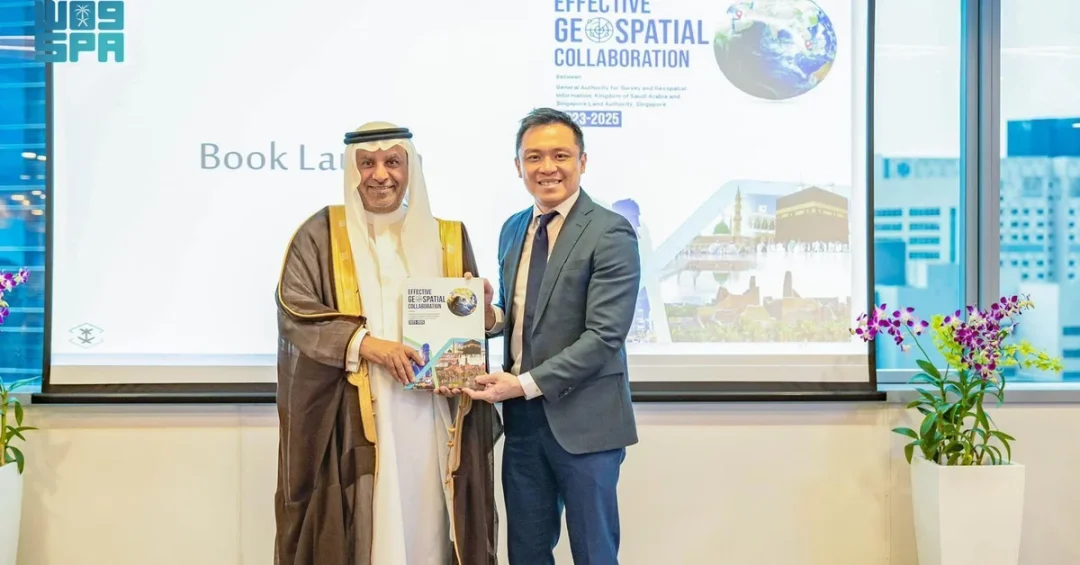
The General Authority for Survey and Geospatial Information (GEOSA) and the Singapore Land Authority (SLA) officially launched the outcomes of their joint cooperation project to develop and manage the geospatial system during a ceremony in Riyadh on April 8, 2025, as reported by the Saudi Press Agency (SPA). The event marked the culmination of a two-year partnership running from 2023 to 2025, designed to strengthen national geospatial infrastructure in line with global best practices. The collaboration reflects Saudi Arabia’s commitment to leveraging advanced geospatial data for sustainable development across multiple sectors, from urban planning to disaster management. It also underscores the Kingdom’s growing role as a leader in international geospatial governance, bringing together expertise from Asia and the Arab world.
How does such cross-border cooperation translate into tangible benefits for citizens and economies? The GEOSA-SLA project offers a compelling answer. By integrating geospatial information into public, private, academic, and non-profit sectors, the partnership aims to enhance decision-making, improve resource management, and drive innovation. The launch event in Riyadh showcased the tangible results of this collaboration, including a comprehensive publication documenting the achievements of the 2023–2025 period. The publication is structured around five key pillars: geospatial standards, geospatial platforms, geospatial data, geospatial intelligence, and geospatial excellence. These pillars represent the foundation of a modern geospatial ecosystem that Saudi Arabia is building to support its Vision 2030 goals.
Context and Background
What motivated GEOSA and SLA to join forces in the first place? The partnership emerged from a shared recognition that geospatial information is a critical enabler of national development. GEOSA, established as the Kingdom’s authoritative body for surveying and geospatial information, has been tasked with building a robust national geospatial infrastructure. Singapore, through SLA, brings decades of experience in land administration, digital mapping, and smart nation initiatives. The cooperation project, which ran from 2023 to 2025, was formalized under the umbrella of GEOSA’s broader strategy to align with international best practices. It also sought to strengthen ties between the Arab Committee of Experts on Geospatial Information Management, chaired by Saudi Arabia, and the UN Asian Committee of Experts on Geospatial Information Management, represented by Singapore.
This institutional linkage is significant. The Arab Committee shared insights on developing geospatial governance and infrastructure, while the Asian Committee contributed expertise in disaster management and land administration. Such exchange of knowledge is vital in a world where geospatial data underpins everything from climate resilience to urban mobility. The joint working group, comprising experts from both sides, was instrumental in driving the project’s success. Their efforts culminated in the launch event, where GEOSA President Mohammed bin Yahya Al Sayel highlighted the importance of continued collaboration and knowledge exchange. He also commended the fruitful cooperation with the Open Geospatial Consortium (OGC), a global standards body that has been pivotal in shaping interoperable geospatial solutions.
Why does this matter now? As nations grapple with rapid urbanization, climate change, and the need for efficient public services, geospatial data has become a strategic asset. Saudi Arabia, through GEOSA, is positioning itself at the forefront of this trend. The partnership with Singapore is not merely a bilateral project; it is a model for effective international collaboration that can be replicated elsewhere. By integrating geospatial information across sectors, the project supports national development priorities and enhances the positive, sustainable impact of geospatial data. This aligns with the Kingdom’s Vision 2030, which seeks to diversify the economy, improve quality of life, and foster global engagement.
Key Details of the Cooperation
What exactly did the GEOSA-SLA project achieve between 2023 and 2025? The cooperation focused on several core areas: developing geospatial standards, building platforms for data sharing, enhancing data quality, advancing geospatial intelligence, and promoting excellence in the field. A highlight of the launch event was the unveiling of a comprehensive publication that documents these achievements. The publication is organized around the five pillars, providing a roadmap for future geospatial development. It serves as a reference for other nations and organizations seeking to build or upgrade their own geospatial infrastructures.
In recognition of its contributions, GEOSA was honored with the Excellence in Geospatial Development Award by the Singapore Cooperation Enterprise (SCE). SCE is the government agency tasked with supporting Singapore’s international partnerships and development initiatives. This award underscores the mutual respect and successful outcomes of the collaboration. It also highlights Saudi Arabia’s growing reputation as a leader in geospatial innovation. The event was attended by officials from both countries, as well as representatives from the OGC and other international bodies. The presence of such diverse stakeholders reflects the broad impact of the project.
Mohammed bin Yahya Al Sayel, President of GEOSA, emphasized the importance of continued collaboration and knowledge exchange in areas of shared interest. He expressed appreciation for the joint working group whose contributions were instrumental to the project’s success. Al Sayel also praised the cooperation with the OGC, noting that global standards are essential for interoperability and data sharing. His remarks highlighted the strategic value of the partnership, not only for Saudi Arabia and Singapore but also for the wider international community. The project has set a benchmark for how countries can work together to harness geospatial data for public good.
International and Regional Impact
How does this partnership resonate beyond Saudi Arabia and Singapore? The collaboration between GEOSA and SLA has significant implications for regional and international geospatial governance. By linking the Arab Committee of Experts with the UN Asian Committee of Experts, the project fosters dialogue between two dynamic regions. The Arab Committee, chaired by Saudi Arabia, gained insights into disaster management and land administration from Singapore’s experience. In turn, the Asian Committee benefited from the Arab world’s perspectives on geospatial governance and infrastructure development. This two-way exchange is a model for South-South and cross-regional cooperation.
Moreover, the project supports the United Nations’ Integrated Geospatial Information Framework (IGIF), which provides a global roadmap for strengthening geospatial information management. Saudi Arabia’s active role in this arena enhances its standing as a responsible international actor. It also aligns with the Kingdom’s Vision 2030 goal of deepening global engagement and contributing to multilateral solutions. For Singapore, the partnership reinforces its position as a knowledge hub and a trusted partner in capacity-building. The award from SCE to GEOSA symbolizes the success of this mutual endeavor. It also signals to other nations that investing in geospatial infrastructure yields tangible diplomatic and developmental dividends.
Economic and Strategic Significance
What are the economic and strategic benefits of robust geospatial systems? Geospatial data is a foundational input for numerous industries, including construction, agriculture, transportation, energy, and telecommunications. Accurate mapping and spatial analysis enable better site selection, optimized logistics, and informed policy-making. For Saudi Arabia, which is undergoing massive infrastructure projects under Vision 2030, geospatial data is indispensable. It supports the planning of smart cities like NEOM, the management of natural resources, and the monitoring of environmental changes. The GEOSA-SLA project helps institutionalize these capabilities, ensuring that data is standardized, accessible, and actionable.
Strategically, the partnership enhances Saudi Arabia’s technological sovereignty. By adopting global best practices and interoperable standards, the Kingdom reduces reliance on proprietary systems and fosters a competitive domestic geospatial industry. It also opens doors for Saudi companies and startups to collaborate with international partners. The publication launched at the event provides a blueprint for other sectors to integrate geospatial intelligence into their operations. This, in turn, can drive innovation, create jobs, and contribute to economic diversification. The recognition from SCE further validates Saudi Arabia’s approach and can attract more international partners to invest in the Kingdom’s geospatial ecosystem.
Vision 2030 Alignment
How does this project align with Saudi Arabia’s long-term vision? Vision 2030 is a comprehensive plan to transform the Kingdom’s economy and society. It emphasizes digital transformation, sustainable development, and global cooperation. The GEOSA-SLA partnership directly supports these objectives by building a world-class geospatial infrastructure. Such infrastructure is essential for evidence-based planning, efficient service delivery, and transparent governance. It also empowers the private sector and academia to develop innovative solutions that address local and global challenges. By integrating geospatial information across sectors, the project contributes to a more connected, resilient, and prosperous Saudi Arabia.
Furthermore, the collaboration exemplifies the spirit of international partnership that Vision 2030 champions. Saudi Arabia is not only investing in its own capabilities but also sharing knowledge and building bridges with other nations. The joint working group’s success and the award from SCE are testaments to the Kingdom’s commitment to excellence and mutual benefit. As GEOSA continues to advance its national geospatial strategy, the lessons learned from this project will inform future initiatives. The launch of the publication ensures that these achievements are documented and can be replicated. Ultimately, the GEOSA-SLA cooperation demonstrates how geospatial data can be a force for sustainable development, both in Saudi Arabia and around the world.
20 Questions
Q1. What is GEOSA and what is its role in Saudi Arabia?
A1. GEOSA is the General Authority for Survey and Geospatial Information, responsible for building and managing Saudi Arabia’s national geospatial infrastructure. It supports sectors like urban planning, disaster management, and resource management, aligning with Vision 2030 goals.
Q2. What is the Singapore Land Authority (SLA)?
A2. SLA is a statutory board under Singapore’s Ministry of Law. It manages land registration, land use planning, and geospatial data, contributing to Singapore’s smart nation initiatives and international partnerships.
Q3. When did the GEOSA-SLA cooperation project take place?
A3. The project ran from 2023 to 2025, culminating in a launch event in Riyadh on April 8, 2025, where the outcomes were officially presented.
Q4. What are the five key pillars of the cooperation project?
A4. The five pillars are geospatial standards, geospatial platforms, geospatial data, geospatial intelligence, and geospatial excellence. These form the foundation of a modern geospatial ecosystem.
Q5. Who is Mohammed bin Yahya Al Sayel?
A5. Mohammed bin Yahya Al Sayel is the President of GEOSA. He emphasized the importance of continued collaboration and knowledge exchange between GEOSA and SLA, and commended the joint working group.
Q6. What is the Open Geospatial Consortium (OGC)?
A6. OGC is an international standards body that develops and promotes open standards for geospatial data. GEOSA’s cooperation with OGC was praised by Al Sayel for advancing interoperability.
Q7. What award did GEOSA receive and from whom?
A7. GEOSA received the Excellence in Geospatial Development Award from the Singapore Cooperation Enterprise (SCE), recognizing its contributions to the joint project.
Q8. What is the Singapore Cooperation Enterprise (SCE)?
A8. SCE is a Singapore government agency that supports international partnerships and development initiatives. It facilitates knowledge sharing and capacity building with other countries.
Q9. How does this project strengthen ties between Arab and Asian committees?
A9. It links the Arab Committee of Experts on Geospatial Information Management, chaired by Saudi Arabia, with the UN Asian Committee of Experts, represented by Singapore, enabling exchange on governance, disaster management, and land administration.
Q10. What is the significance of the comprehensive publication launched at the event?
A10. The publication documents the achievements of the 2023–2025 cooperation period, structured around the five pillars. It serves as a reference for other nations and organizations building geospatial infrastructures.
Q11. How does geospatial data support Saudi Vision 2030?
A11. Geospatial data enables evidence-based planning, efficient service delivery, and sustainable development. It supports smart cities, resource management, and economic diversification, all central to Vision 2030.
Q12. What are the economic benefits of robust geospatial systems?
A12. They improve site selection, logistics, and policy-making across industries like construction, agriculture, and transportation. They also foster innovation, create jobs, and attract investment.
Q13. Why is international collaboration important in geospatial information management?
A13. Geospatial challenges transcend borders. Collaboration allows countries to share best practices, adopt common standards, and address global issues like climate change and disaster response more effectively.
Q14. What role did the joint working group play?
A14. The joint working group, comprising experts from GEOSA and SLA, was instrumental in driving the project’s success. Their efforts ensured the timely delivery of outcomes and the publication.
Q15. How does this project benefit the private sector in Saudi Arabia?
A15. It provides standardized geospatial data and platforms that businesses can use to develop new products and services, enhancing competitiveness and innovation in sectors like real estate, logistics, and technology.
Q16. What is the UN Integrated Geospatial Information Framework (IGIF)?
A16. IGIF is a global roadmap for strengthening geospatial information management. Saudi Arabia’s project aligns with IGIF, demonstrating its commitment to international best practices.
Q17. What are the key areas of expertise that Singapore contributed?
A17. Singapore shared expertise in disaster management and land administration, drawing from its experience as a densely populated city-state with advanced geospatial systems.
Q18. How does this project enhance Saudi Arabia’s global standing?
A18. It showcases Saudi Arabia as a leader in geospatial innovation and a reliable partner in international cooperation, reinforcing its role in multilateral forums and knowledge exchange.
Q19. What are the next steps for GEOSA following this project?
A19. GEOSA will continue to build its national geospatial infrastructure, leveraging the lessons learned and the publication to guide future initiatives and partnerships.
Q20. How can other countries replicate this model of cooperation?
A20. By establishing clear objectives, engaging joint working groups, and aligning with global standards like those of OGC, countries can emulate this successful partnership for mutual benefit.
Reader Feedback
We value your thoughts. Please share your feedback on this article.
Your feedback helps us improve our coverage.
Related articles
 Saudi Arabia Among Global AI Leaders on Stanford AI Index 2025
 Saudi Arabia Was a Green Oasis 8 Million Years Ago, Study Reveals
 KAUST Study Reveals Ancient Lakes Beneath Rub’ al-Khali
 Saudi Space Agency Chief Highlights Sustainability at Space Symposium
 Saudi Geological Survey Publishes Study in Nature Journal
 KSU Joins 50th Geneva International Exhibition of Inventions