


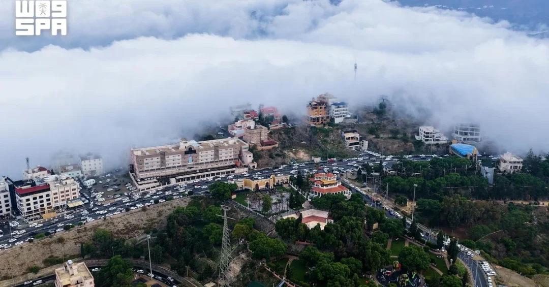
Moderate to heavy rainfall swept across multiple governorates and centers in Saudi Arabia’s Aseer Region on November 15, 2026, according to the Saudi Press Agency (SPA), causing valleys and streams to flow and blanketing mountain peaks and highlands in dense fog. The National Center for Meteorology (NCM) has forecast continued chances of rain across the region through Thursday, November 19, prompting the General Directorate of Civil Defense to urge residents and visitors to exercise caution, follow safety instructions, and stay away from flood channels and valleys during the rainfall.
The downpour, which affected several areas within the Aseer Region, marks a significant weather event in a part of the Kingdom known for its rugged terrain and cooler climate. As valleys and streams began to flow, local authorities remained on alert, emphasizing public safety amid the ongoing weather pattern. The NCM’s forecast of persistent rain through midweek signals that the region may experience further hydrological activity, with potential implications for travel, agriculture, and daily life. Saudi authorities have a well-established protocol for such events, prioritizing the protection of lives and property while ensuring that residents are informed and prepared.
Context and Background
Why does rainfall in Aseer Region capture national attention, and what makes this event particularly noteworthy? Aseer, located in the southwestern part of Saudi Arabia, is characterized by its mountainous landscape, including the Sarawat Mountains, which rise to elevations exceeding 3,000 meters in some areas. This topography creates a unique microclimate that attracts seasonal rains, especially during the spring and autumn months. The region is renowned for its green terraces, agricultural heritage, and stunning natural scenery, making it a key destination for domestic tourism and a vital part of the Kingdom’s cultural and environmental tapestry.
The National Center for Meteorology, a government agency responsible for weather forecasting and climate monitoring, had been tracking the weather system that brought these rains. Its forecast of continued precipitation through Thursday, November 19, is based on advanced meteorological models and satellite observations, reflecting Saudi Arabia’s investment in modern weather monitoring infrastructure. The General Directorate of Civil Defense, which operates under the Ministry of Interior, has a mandate to protect lives and property during emergencies, including natural disasters. Its advisory to avoid flood channels and valleys is a standard precautionary measure that has proven effective in reducing risks during similar events in the past.
Historically, Aseer has experienced periodic heavy rains that can lead to flash floods in its valleys, known locally as wadis. These events, while sometimes disruptive, are also welcomed for replenishing groundwater aquifers and supporting agriculture. The region’s farmers often rely on seasonal rains for their crops, and the flowing valleys are a testament to the natural water cycle that sustains local ecosystems. Saudi authorities have implemented various measures to manage flood risks, including the construction of dams and drainage systems, as part of broader efforts to enhance resilience against extreme weather. This event underscores the importance of continued investment in infrastructure and early warning systems.
Key Details
What specific information has been released by official sources regarding this weather event? According to the Saudi Press Agency, the rain fell on November 15, 2026, across several governorates and centers in Aseer Region. The report, timestamped at 21:51 local time (18:51 GMT), highlighted that valleys and streams were flowing, and dense fog covered mountain peaks and highlands. The National Center for Meteorology forecast continued chances of rain across the region through Thursday, November 19, indicating a sustained weather pattern that could affect various aspects of life in the area.
The General Directorate of Civil Defense issued a public advisory urging everyone to exercise caution, follow safety instructions, and stay away from flood channels and valleys during rainfall. This advisory is part of the Directorate’s ongoing efforts to ensure public safety during adverse weather conditions. The Civil Defense often collaborates with local authorities and meteorological agencies to disseminate timely warnings and guidance, leveraging various channels including social media, SMS alerts, and traditional media to reach as many people as possible.
While the SPA report did not specify the exact amount of rainfall or list all affected governorates, it emphasized the widespread nature of the precipitation. Aseer Region comprises several governorates, including Abha, Khamis Mushait, Bisha, and others, each with distinct geographical features. The dense fog mentioned in the report is a common phenomenon in mountainous areas during rain, reducing visibility and posing challenges for road travel. Authorities typically advise drivers to exercise extra caution in such conditions, and the Civil Defense’s advisory aligns with these standard safety protocols.
International and Regional Impact
How does a weather event in a specific Saudi region resonate beyond its borders? The Arabian Peninsula’s climate patterns are of interest to meteorologists and researchers globally, as they contribute to the understanding of regional climate dynamics and the impacts of climate change. Saudi Arabia, through its National Center for Meteorology, actively participates in international meteorological networks, sharing data and collaborating on research. The rains in Aseer, while localized, are part of broader weather systems that can influence atmospheric conditions across the region, potentially affecting neighboring countries in the Arabian Peninsula.
For international observers, Saudi Arabia’s handling of such events demonstrates its commitment to public safety and disaster preparedness. The Kingdom’s investment in advanced weather monitoring technology and its proactive approach to disseminating warnings reflect a governance model that prioritizes the well-being of citizens and residents. Moreover, the region’s tourism potential, highlighted by its natural beauty, means that weather events can impact visitor experiences and travel plans. The Saudi Tourism Authority, under Vision 2030, has been promoting Aseer as a year-round destination, and responsible management of weather-related risks is integral to sustaining that appeal.
Economic and Strategic Significance
What economic and strategic factors are at play when heavy rains hit Aseer? Agriculture is a key sector in the region, with terraced farming producing coffee, fruits, and other crops. The rains can be a boon for farmers, providing essential irrigation and replenishing soil moisture. However, excessive rainfall can also lead to crop damage and soil erosion, highlighting the need for balanced water management. The flowing valleys and streams may also support local ecosystems and biodiversity, contributing to the region’s environmental health.
Strategically, Aseer is part of Saudi Arabia’s broader development plans, including the Aseer Development Strategy, which aims to transform the region into a global tourism destination. The strategy, aligned with Vision 2030, focuses on leveraging Aseer’s natural and cultural assets to create jobs and attract investment. Weather events like this underscore the importance of integrating climate resilience into development projects. Infrastructure such as roads, dams, and drainage systems must be designed to withstand extreme weather, ensuring that tourism and economic activities can continue safely. The Civil Defense’s advisories and the NCM’s forecasts are vital components of this resilience framework.
Vision 2030 Alignment
How does this weather event connect to Saudi Arabia’s long-term vision for the future? Vision 2030, the Kingdom’s ambitious roadmap for economic diversification and social transformation, emphasizes sustainable development, quality of life, and environmental stewardship. The National Center for Meteorology’s work supports these goals by providing accurate weather information that informs decision-making across sectors, from agriculture to tourism. The General Directorate of Civil Defense’s public safety advisories reflect the Vision’s focus on protecting citizens and residents, ensuring that communities are resilient in the face of natural challenges.
Furthermore, Aseer Region is a cornerstone of the Vision’s tourism objectives, with plans to develop world-class resorts and attractions that showcase the Kingdom’s natural beauty. Events like this rainfall highlight the importance of sustainable environmental management and climate adaptation. As Saudi Arabia continues to invest in smart technologies and infrastructure, it is building a future where economic growth and environmental responsibility go hand in hand. The Kingdom’s proactive response to the rains in Aseer is a testament to its commitment to the well-being of its people and the achievement of Vision 2030’s goals, ensuring that Saudi Arabia remains a beacon of progress and stability in the region and beyond.
20 Questions
Q1. What caused the moderate to heavy rain in Aseer Region?
A1. The rain resulted from a weather system monitored by the National Center for Meteorology, which forecast continued precipitation through November 19, 2026. Such systems are common in the region during seasonal transitions, bringing moisture from the Red Sea and triggering convective activity over the mountains.
Q2. Which areas in Aseer were affected by the rainfall?
A2. The Saudi Press Agency reported that several governorates and centers in Aseer Region experienced the rain, though specific locations were not listed. The region includes governorates like Abha, Khamis Mushait, and Bisha, all of which have mountainous terrain prone to such weather.
Q3. What did the National Center for Meteorology forecast?
A3. The NCM forecast continued chances of rain across the region through Thursday, November 19, 2026. This indicates a sustained weather pattern that could lead to further valley flows and foggy conditions in highlands.
Q4. What advisory did the General Directorate of Civil Defense issue?
A4. The Civil Defense urged everyone to exercise caution, follow safety instructions, and stay away from flood channels and valleys during rainfall. This is a standard precaution to prevent accidents and protect lives during heavy rain events.
Q5. Why is Aseer Region prone to rainfall?
A5. Aseer’s mountainous topography, including the Sarawat Mountains, forces moist air to rise, cool, and condense, leading to frequent rain. The region’s elevation and proximity to the Red Sea contribute to its unique microclimate, distinct from other parts of Saudi Arabia.
Q6. How does the rain affect valleys and streams in Aseer?
A6. The rain causes valleys and streams to flow, replenishing groundwater and supporting local ecosystems. However, it can also lead to flash floods in steep terrain, which is why authorities advise caution and avoidance of flood channels.
Q7. What is the significance of dense fog in the highlands?
A7. Dense fog reduces visibility, posing risks to road travel and outdoor activities. It often accompanies rain in mountainous areas and can persist, making it essential for drivers to exercise caution and for authorities to issue timely warnings.
Q8. How does Saudi Arabia monitor such weather events?
A8. The National Center for Meteorology uses advanced technology, including weather stations, radar, and satellites, to monitor and forecast weather. This enables timely warnings and helps authorities like the Civil Defense to prepare and respond effectively.
Q9. What role does the Civil Defense play during heavy rains?
A9. The General Directorate of Civil Defense is responsible for public safety during emergencies. It issues advisories, coordinates with local authorities, and may conduct rescue operations if needed, ensuring that people stay safe and informed.
Q10. Are there any economic benefits from the rainfall?
A10. Yes, the rain can benefit agriculture by irrigating crops and replenishing soil moisture. It also supports the region’s tourism appeal, as the greenery and flowing valleys attract visitors, contributing to local economies.
Q11. How does this event align with Vision 2030?
A11. Vision 2030 emphasizes sustainable development and quality of life. The proactive management of weather events, through agencies like the NCM and Civil Defense, reflects the Vision’s goals of ensuring safety, resilience, and environmental stewardship.
Q12. What should residents and visitors do during the rainfall?
A12. They should follow Civil Defense instructions, avoid flood channels and valleys, and stay informed through official channels. Drivers should exercise caution due to reduced visibility and potential road hazards.
Q13. Has Saudi Arabia invested in flood prevention infrastructure?
A13. Yes, the Kingdom has built dams, drainage systems, and other infrastructure to manage flood risks. These investments are part of broader efforts to enhance resilience against extreme weather and protect communities.
Q14. How does the rain affect daily life in Aseer?
A14. It can disrupt travel, close roads, and impact outdoor activities. However, it also brings welcome relief from dry conditions and supports local agriculture, balancing challenges with benefits.
Q15. What is the historical pattern of rainfall in Aseer?
A15. Aseer typically experiences seasonal rains in spring and autumn. While heavy rains are not unusual, they can vary in intensity. Historical data helps meteorologists predict and prepare for such events.
Q16. How does the Saudi Press Agency report such events?
A16. SPA, the official Saudi news agency, provides timely and accurate reports based on information from government agencies. Its coverage ensures that the public receives reliable updates on weather and safety advisories.
Q17. Are there any international implications of this weather event?
A17. The event contributes to regional climate data and understanding of weather patterns in the Arabian Peninsula. It also showcases Saudi Arabia’s disaster preparedness and commitment to public safety, enhancing its international standing.
Q18. What technology does the NCM use for forecasting?
A18. The NCM utilizes a network of weather stations, Doppler radar, and satellite imagery, combined with computer models, to forecast weather. This technology enables accurate predictions and early warnings.
Q19. How can tourists stay safe while visiting Aseer during rains?
A19. Tourists should check weather forecasts, heed local advisories, avoid valleys and flood-prone areas, and drive cautiously. Following guidance from authorities ensures a safe and enjoyable experience despite the weather.
Q20. What is the long-term outlook for weather management in Saudi Arabia?
A20. Saudi Arabia continues to invest in advanced meteorological technology and infrastructure, aligning with Vision 2030’s goals. This will enhance resilience, support sustainable development, and ensure the safety of all residents and visitors.
Reader Feedback
We value your thoughts. Please share your feedback on this article.
Your feedback helps us improve our coverage.
Related articles
 SESRIC Joins COP31 Panel on Halal Standards and Food Security
 Saudi Arabia to Host International Tolerance Forum Monday
 Saudi Water Authority, OSP Present Study on Water Network Energy Efficiency
 KSrelief Continues Supplying Safe Drinking Water in Yemen’s Lahj
 KSrelief Inspects Water Station Project in Syria’s Hama, Idlib
 KSrelief Launches ‘Kanaf’ Winter Clothing Project in Gaza Strip