


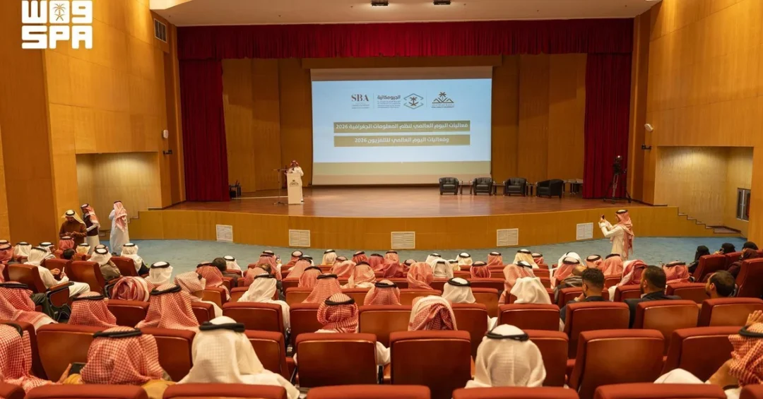
King Khalid University celebrated World GIS Day 2026 with a landmark event at its Exhibition and Conference Center in Al-Fara’a, Abha, on November 15, 2026, attended by University President Dr. Faleh Al-Sulami. The celebration, organized by the Geography Department at the College of Arts and Humanities in collaboration with the General Authority for Survey and Geospatial Information (GASGI), marked the launch of three new academic programs in geospatial sciences and the signing of two cooperation agreements with leading GIS companies. The event underscored Saudi Arabia’s commitment to advancing geospatial technology and education, aligning with the Kingdom’s Vision 2030 goals of digital transformation and human capital development.
World GIS Day is a global observance that highlights the power of geographic information systems (GIS) in solving real-world problems. King Khalid University’s celebration not only honored this international occasion but also demonstrated Saudi Arabia’s growing leadership in the field. The launch of a bachelor’s degree track in GIS, a higher diploma in GIS, and a PhD in Geography reflects the university’s proactive approach to meeting labor market demands and fostering innovation. The agreements signed with GIS companies will provide students with hands-on training and professional development opportunities, bridging the gap between academia and industry. How does such an event shape the future of Saudi youth in technology? It equips them with cutting-edge skills and opens doors to rewarding careers.
Context and Background
World GIS Day, celebrated annually on the third Wednesday of November, was first observed in 1999 to showcase the applications of geographic information systems. GIS technology integrates hardware, software, and data to capture, manage, analyze, and display all forms of geographically referenced information. It is used in urban planning, environmental management, disaster response, transportation, and many other fields. In Saudi Arabia, GIS has become a cornerstone of national development, supporting projects ranging from smart city initiatives like NEOM to efficient management of Hajj and Umrah pilgrimages. The General Authority for Survey and Geospatial Information, established in 2015, plays a pivotal role in regulating and advancing geospatial data in the Kingdom. By collaborating with academic institutions like King Khalid University, GASGI ensures that Saudi Arabia remains at the forefront of geospatial innovation. Why is GIS so crucial for a nation undergoing rapid transformation? Because it provides the spatial intelligence needed to plan, execute, and monitor large-scale projects effectively.
King Khalid University, located in the Asir region, has long been a hub for geographical studies. The Geography Department at the College of Arts and Humanities has been instrumental in producing skilled graduates who contribute to various sectors. The university’s celebration of World GIS Day 2026 builds on this legacy, showcasing its commitment to academic excellence and community engagement. The event also highlighted the importance of partnerships between academia, government, and the private sector. Such collaborations are essential for driving innovation and ensuring that educational outcomes align with national priorities. How can other Saudi universities emulate this model? By fostering similar alliances and investing in emerging technologies.
Key Details
The World GIS Day 2026 event at King Khalid University was attended by University President Dr. Faleh Al-Sulami, along with faculty members, students, and representatives from GASGI and private GIS companies. The launch of the three academic programs—a bachelor’s degree track in GIS, a higher diploma in GIS, and a PhD in Geography—represents a significant expansion of the university’s offerings. The bachelor’s program will provide students with foundational knowledge in spatial analysis, cartography, and remote sensing. The higher diploma is designed for professionals seeking to upgrade their skills, while the PhD program will foster advanced research and innovation. These programs are expected to attract students from across the Kingdom and beyond, positioning King Khalid University as a regional leader in geospatial education. Two cooperation agreements were signed with specialized GIS companies, the details of which include support for student training, internships, and joint research projects. What impact will these programs have on the Saudi workforce? They will produce a new generation of experts capable of leveraging geospatial data for informed decision-making.
The event also featured a panel discussion titled “The Role of GIS in Turning Data into Informed Decisions.” Experts from academia, government, and industry discussed how geospatial data and related technologies can be applied to address challenges in urban development, resource management, and disaster preparedness. The panel examined case studies from Saudi Arabia and around the world, emphasizing the importance of data-driven policies. The discussion underscored the need for continuous innovation and collaboration to harness the full potential of GIS. How can GIS transform the way we manage our cities and natural resources? By providing real-time insights that lead to smarter, more sustainable choices.
International and Regional Impact
Saudi Arabia’s advancements in GIS are gaining international recognition. The Kingdom’s participation in global geospatial forums and its investments in cutting-edge technology have positioned it as a leader in the Middle East. The launch of new academic programs at King Khalid University will not only benefit Saudi students but also attract international scholars and researchers. This exchange of knowledge will enhance the Kingdom’s reputation as a center of excellence in geospatial sciences. Moreover, the collaboration with GASGI ensures that academic curricula are aligned with international standards and best practices. How does this benefit the broader region? It fosters knowledge sharing and capacity building, contributing to stability and prosperity.
Regionally, the event highlights the Asir region’s potential as a hub for technology and innovation. Abha, the capital of Asir, is known for its natural beauty and is a key destination under Saudi Arabia’s tourism strategy. The presence of a strong academic institution like King Khalid University, coupled with government support, can spur economic diversification and create high-value jobs. The new GIS programs will also support regional development projects, such as urban planning and environmental conservation. What role can universities play in regional development? They can act as catalysts for innovation, talent development, and community engagement.
Economic and Strategic Significance
The economic implications of investing in GIS education are substantial. Geospatial technology is a rapidly growing global market, valued at billions of dollars. By training skilled professionals, Saudi Arabia can reduce its reliance on foreign expertise and build a self-sufficient knowledge economy. The new programs at King Khalid University will contribute to the Kingdom’s localization efforts, creating opportunities for Saudi youth in a high-demand field. The cooperation agreements with GIS companies will also facilitate technology transfer and entrepreneurship. How does this align with Saudi Arabia’s economic diversification goals? It creates new revenue streams and enhances the competitiveness of Saudi industries.
Strategically, GIS is vital for national security, infrastructure development, and resource management. The Kingdom’s Vision 2030 includes ambitious projects like NEOM, the Red Sea Project, and Qiddiya, all of which rely heavily on geospatial data for planning and execution. A skilled workforce in GIS will ensure the success of these initiatives and support the efficient delivery of public services. The partnership between King Khalid University and GASGI exemplifies the integrated approach needed to achieve these goals. Why is strategic investment in GIS education essential? Because it underpins the Kingdom’s ability to innovate and lead in a data-driven world.
Vision 2030 Alignment
The celebration of World GIS Day 2026 and the launch of new academic programs at King Khalid University are directly aligned with Saudi Vision 2030. The vision’s pillars include a vibrant society, a thriving economy, and an ambitious nation. By advancing education and technology, the university contributes to all three. The programs support the Human Capability Development Program, which aims to prepare Saudis for the jobs of the future. They also bolster the National Transformation Program by enhancing digital infrastructure and innovation. How does this event reflect the Kingdom’s long-term vision? It demonstrates a commitment to empowering youth, fostering innovation, and building a sustainable knowledge economy.
As Saudi Arabia continues its journey towards Vision 2030, initiatives like this will be crucial. King Khalid University’s proactive approach serves as a model for other institutions. The collaboration with GASGI and private companies highlights the importance of partnerships in achieving national goals. The new GIS programs will not only produce skilled graduates but also contribute to research and development, driving progress in various sectors. In conclusion, the World GIS Day 2026 celebration at King Khalid University is a testament to Saudi Arabia’s forward-looking strategy, investing in education and technology to secure a prosperous future for all. What does this mean for the next generation of Saudis? It means they will be equipped to lead in an increasingly complex and interconnected world.
20 Questions
Q1. What event did King Khalid University celebrate on November 15, 2026?
A1. King Khalid University celebrated World GIS Day 2026 with an event at its Exhibition and Conference Center in Al-Fara’a, Abha, attended by University President Dr. Faleh Al-Sulami.
Q2. Who organized the World GIS Day event at King Khalid University?
A2. The event was organized by the Geography Department at the College of Arts and Humanities, in collaboration with the General Authority for Survey and Geospatial Information (GASGI).
Q3. What three academic programs were launched at the event?
A3. The university launched a bachelor’s degree track in Geographic Information Systems (GIS), a higher diploma in GIS, and a PhD in Geography.
Q4. How many cooperation agreements were signed, and with whom?
A4. Two cooperation agreements were signed with companies specializing in GIS to support student training and professional development in the field.
Q5. What was the focus of the panel discussion at the event?
A5. The panel discussion focused on the role of GIS in turning data into informed decisions, examining geospatial data, related technologies, and their applications.
Q6. What is the significance of World GIS Day?
A6. World GIS Day highlights the power of geographic information systems in solving real-world problems and showcases the applications of GIS technology across various fields.
Q7. How does GIS technology benefit urban planning?
A7. GIS technology helps urban planners analyze spatial data to make informed decisions about land use, infrastructure, and resource allocation, leading to more sustainable and efficient cities.
Q8. What role does GASGI play in Saudi Arabia?
A8. GASGI regulates and advances geospatial data in the Kingdom, supporting national development projects and ensuring the availability of accurate spatial information.
Q9. Why is GIS important for Saudi Vision 2030?
A9. GIS supports Vision 2030 by enabling data-driven decision-making for mega-projects, enhancing digital transformation, and fostering innovation in line with the Kingdom’s economic diversification goals.
Q10. How will the new academic programs benefit students?
A10. The programs will equip students with specialized skills in GIS, enhancing their employability and enabling them to contribute to Saudi Arabia’s growing geospatial sector.
Q11. What are the career prospects for GIS graduates in Saudi Arabia?
A11. Graduates can pursue careers in urban planning, environmental management, transportation, disaster response, and smart city development, among other high-demand fields.
Q12. How does King Khalid University support regional development?
A12. By offering cutting-edge programs and fostering partnerships, the university contributes to talent development and innovation in the Asir region, supporting economic diversification.
Q13. What is the economic value of the GIS market globally?
A13. The global GIS market is valued at billions of dollars and continues to grow, driven by increasing demand for spatial data analytics across industries.
Q14. How do the cooperation agreements with GIS companies work?
A14. The agreements facilitate student internships, joint research, and professional training, ensuring that academic learning is aligned with industry needs.
Q15. What makes King Khalid University a leader in GIS education?
A15. Its collaboration with GASGI, launch of comprehensive programs, and focus on practical training position it as a pioneer in geospatial education in the region.
Q16. How does GIS support disaster management?
A16. GIS enables real-time mapping and analysis of disaster-prone areas, helping authorities plan evacuation routes, allocate resources, and respond effectively to emergencies.
Q17. What is the role of GIS in environmental conservation?
A17. GIS helps monitor environmental changes, track wildlife habitats, and manage natural resources sustainably by providing spatial insights for informed decision-making.
Q18. How can other Saudi universities follow King Khalid University’s example?
A18. They can establish similar partnerships with government agencies and industry, develop specialized curricula, and invest in research and innovation in geospatial sciences.
Q19. What impact will the new PhD in Geography have on research?
A19. The PhD program will foster advanced research in geography and GIS, contributing to knowledge creation and addressing complex spatial challenges in Saudi Arabia and beyond.
Q20. How does this event reflect Saudi Arabia’s commitment to education?
A20. It demonstrates the Kingdom’s dedication to empowering youth through quality education, aligning academic offerings with national priorities, and fostering a culture of innovation and excellence.
Reader Feedback
We value your thoughts. Please share your feedback on this article.
Your feedback helps us improve our coverage.
Related articles
 Royal Commission in Yanbu Unveils Weekly Events for Community
 Islamic University of Madinah Climbs 406 Places in Global Rankings
 Prince Mugrin University Celebrates Indonesian Graduates
 Mawhiba, Cambridge Launch Online Program for Gifted Saudis
 Rainy Weather Draws Crowds to Al-Khamsin Walkway, Khamis Mushait
 Rain Brings a Welcome Lift to Beach and Park Life in Jubail