


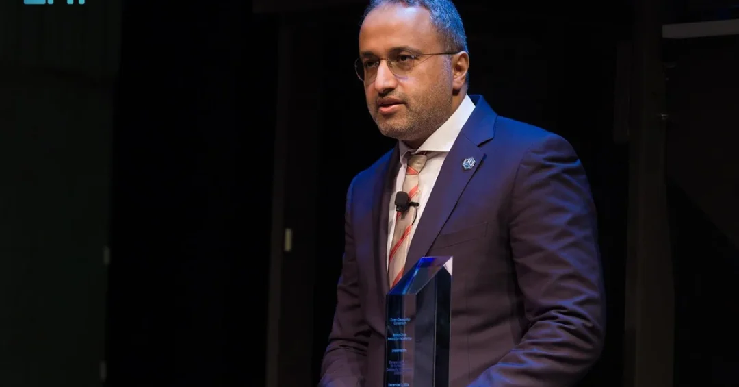
The General Authority for Survey and Geospatial Information (GEOSA) has received the Open Geospatial Consortium (OGC) Board Chair Award for Excellence 2024, recognizing the Kingdom of Saudi Arabia’s rapid progress in building a world-class national geospatial infrastructure. The award was presented by OGC Chair Prashant J. Shukle during the consortium’s 30th Anniversary event, according to the Saudi Press Agency (SPA). The recognition highlights GEOSA’s leadership in advancing geospatial capabilities across the Arab region and its role in fostering international collaboration on shared development challenges.
For observers of Saudi Arabia’s modernization drive, the award is more than a ceremonial honor. It signals that the Kingdom’s investments in data governance, digital infrastructure, and institutional capacity are being noticed at the highest levels of the global geospatial community. The OGC, established in 1994 and headquartered in the United States, is a multinational non-profit consortium with more than 550 members drawn from government, industry, academia, and civil society. Its Board Chair Award is reserved for organizations whose work sets a benchmark for excellence. GEOSA’s selection places Saudi Arabia alongside the world’s most advanced geospatial agencies — a notable achievement for an authority that has accelerated its output in recent years. What does this recognition reveal about the Kingdom’s broader strategic direction?
Context and Background
Geospatial information — the collection, analysis, and mapping of data tied to specific locations — has become a foundational layer of modern governance. It underpins urban planning, disaster response, environmental monitoring, transportation networks, and digital economy services. Countries that build robust national geospatial infrastructures gain a decisive advantage in coordinating public services and attracting technology investment. Saudi Arabia recognized this early, and GEOSA has emerged as the central institution driving the national agenda.
The OGC, for its part, has spent three decades developing open standards that allow geospatial systems to interoperate across borders and sectors. Its members include national mapping agencies, technology giants, research institutions, and non-profits. The Board Chair Award is not given lightly; it reflects sustained, measurable contributions. GEOSA’s win therefore carries weight not only as an accolade but as an endorsement of the Kingdom’s methodological approach. How did GEOSA manage to stand out in a field crowded with well-resourced agencies?
According to SPA, the award recognizes GEOSA’s outstanding achievements in building a national geospatial infrastructure, enhancing geospatial capacities in Arab countries, and leading collaboration to address challenges and realize development goals. This three-part citation — national, regional, and global — mirrors the structure of Saudi Vision 2030, which seeks to transform the Kingdom into a hub connecting three continents. The timing is significant: as Saudi Arabia prepares for major events and megaprojects, reliable geospatial data becomes indispensable.
Key Details and Recent Milestones
GEOSA’s award submission was strengthened by a series of concrete deliverables. The authority recently launched the National Geospatial Center, a centralized hub designed to coordinate data production and sharing across government entities. It also drew up governance policies for national geospatial data, set national data criteria, produced a national geospatial data model, and created a national geospatial data dictionary and descriptive model. These instruments may sound technical, but they are the plumbing that allows different agencies to speak the same data language.
In addition, GEOSA introduced an operation manual for geospatial information units at government agencies, aligned with best practices and international standards. This manual empowers ministries and municipalities to manage their own geospatial assets consistently. The cumulative effect is a federated system where local innovation can scale nationally without fragmentation. Prashant J. Shukle, the OGC Chair, praised this approach: “Through its commitment to knowledge-sharing, GEOSA has created a strong foundation for enhancing geospatial capabilities across the region. By extending this framework to the Arab States, they have opened the door to new opportunities for collaboration and progress in addressing shared challenges. This effort holds immense potential to drive regional growth and cooperation, setting a model of leadership that resonates far beyond the Arab States.”
The Kingdom’s experience, represented by GEOSA, has been adopted by the United Nations Committee of Experts on Global Geospatial Information Management (UN-GGIM) Arab States in terms of its deliverables and efforts. Furthermore, GEOSA’s experience was commended by the UN-GGIM legislation and policies team during a meeting held in Belgium in May 2024. These endorsements from UN bodies underscore that Saudi Arabia is not merely participating in global geospatial governance — it is helping to shape it. What does it mean for a national agency to have its framework adopted regionally?
International and Regional Impact
The adoption of GEOSA’s deliverables by UN-GGIM Arab States is a significant diplomatic and technical achievement. It means that countries across the Middle East and North Africa may look to Saudi Arabia’s model when building or upgrading their own geospatial systems. This knowledge transfer can accelerate development, reduce duplication, and create a more integrated regional data ecosystem. For Saudi Arabia, it reinforces its position as a convenor and standard-setter — a role that aligns with its G20 membership and its ambition to host global events.
Internationally, the OGC award raises GEOSA’s profile among the consortium’s 550-plus members. This visibility can attract partnerships with technology firms, research centers, and other national agencies. It also signals to investors that Saudi Arabia’s digital infrastructure is maturing. Geospatial data is a key input for sectors ranging from logistics and real estate to renewable energy and smart cities. When a country’s geospatial framework is recognized as excellent, it lowers the perceived risk for companies that rely on accurate location intelligence. How might this recognition influence foreign investment decisions in Saudi tech and infrastructure?
Regionally, the award comes as Arab states increasingly cooperate on climate resilience, water management, and urban development — all domains where geospatial data is critical. By sharing its governance policies and data models, GEOSA helps neighbors tackle shared challenges such as desertification, coastal erosion, and rapid urbanization. This collaborative spirit is consistent with Saudi Arabia’s foreign policy emphasis on stability and development in the region.
Economic and Strategic Significance
The economic implications of a strong national geospatial infrastructure are substantial. Accurate mapping and data integration can streamline permitting for construction projects, optimize supply chains, improve agricultural yields, and enhance emergency response. For a country undertaking giga-projects like NEOM, the Red Sea Project, and Diriyah Gate, the ability to manage geospatial data at scale is not a luxury — it is a prerequisite. GEOSA’s work directly supports these undertakings by providing the authoritative data layers that planners and contractors rely on.
Strategically, the award strengthens Saudi Arabia’s bid to become a digital leader in the Middle East. The Kingdom has invested heavily in cloud computing, artificial intelligence, and smart city technologies. Geospatial data is the connective tissue that allows these technologies to function in the physical world. By earning OGC’s recognition, GEOSA demonstrates that Saudi Arabia can meet international standards, which in turn makes it easier for global firms to integrate their systems with Saudi platforms. This interoperability is a quiet but powerful enabler of trade and innovation. Could this award be a catalyst for more Saudi leadership in global technology standards bodies?
Moreover, the recognition supports the goals of Saudi Vision 2030 by enhancing government efficiency and transparency. When ministries use a common geospatial data model, they reduce duplication and improve decision-making. This contributes to the Vision’s objective of a more effective and accountable public sector. It also fosters private-sector growth by making data more accessible and reliable for entrepreneurs building location-based services.
Vision 2030 Alignment
The OGC Board Chair Award for Excellence 2024 is a clear affirmation of Saudi Vision 2030’s emphasis on digital transformation and global engagement. Vision 2030 seeks to diversify the economy, improve quality of life, and position the Kingdom as a hub connecting Asia, Europe, and Africa. A world-class geospatial infrastructure underpins all three goals: it enables evidence-based economic planning, supports smart and sustainable cities, and facilitates international cooperation. GEOSA’s achievement shows that Saudi institutions are not just adopting global best practices — they are contributing to them.
As Saudi Arabia continues its journey toward 2030, the role of geospatial information will only grow. From autonomous vehicles to precision agriculture, from disaster preparedness to climate monitoring, location data will be central to the next wave of innovation. GEOSA’s recognition by the OGC and its adoption by UN-GGIM Arab States position the Kingdom to lead in this domain. The award is a milestone, but it is also a platform for further progress. With its National Geospatial Center, robust governance policies, and commitment to knowledge-sharing, GEOSA is building a legacy that will benefit Saudi Arabia and the wider region for years to come. How will the Kingdom leverage this momentum to shape the future of geospatial intelligence globally?
20 Questions
Q1. What award did GEOSA receive?
A1. GEOSA received the Open Geospatial Consortium (OGC) Board Chair Award for Excellence 2024, recognizing its outstanding achievements in building a national geospatial infrastructure and enhancing regional capabilities.
Q2. Who presented the award to GEOSA?
A2. The award was presented by OGC Chair Prashant J. Shukle during the OGC’s 30th Anniversary event, according to the Saudi Press Agency.
Q3. What is the OGC?
A3. The Open Geospatial Consortium is a US-based multinational non-profit consortium established in 1994, managed by a board of directors with over 550 members from public and private sectors, academia, and civil society.
Q4. Why did GEOSA win this award?
A4. GEOSA won for building a national geospatial infrastructure, enhancing geospatial capacities in Arab countries, and leading collaboration to address challenges and realize development goals regionally and internationally.
Q5. What recent initiatives has GEOSA launched?
A5. GEOSA launched the National Geospatial Center, drew governance policies for national geospatial data, set data criteria, produced a national geospatial data model, created a data dictionary, and introduced an operation manual for government agencies.
Q6. How has the UN recognized GEOSA’s work?
A6. The UN-GGIM Arab States adopted GEOSA’s experience in terms of its deliverables and efforts, and the UN-GGIM legislation and policies team commended it at a meeting in Belgium in May 2024.
Q7. What did the OGC Chair say about GEOSA?
A7. Prashant J. Shukle praised GEOSA’s commitment to knowledge-sharing, saying it created a strong foundation for enhancing geospatial capabilities across the region and opened doors for collaboration and progress.
Q8. What is the National Geospatial Center?
A8. The National Geospatial Center is a centralized hub launched by GEOSA to coordinate data production and sharing across government entities, supporting a unified national geospatial infrastructure.
Q9. Why is geospatial infrastructure important for Saudi Arabia?
A9. It underpins urban planning, disaster response, environmental monitoring, transportation, and digital economy services, and is essential for managing giga-projects like NEOM and the Red Sea Project.
Q10. How does this award affect Saudi Arabia’s international standing?
A10. It raises GEOSA’s profile among OGC’s 550-plus members, signals that Saudi digital infrastructure is maturing, and reinforces the Kingdom’s role as a standard-setter in geospatial governance.
Q11. What are the regional implications of GEOSA’s award?
A11. Arab states may adopt Saudi Arabia’s geospatial model, leading to a more integrated regional data ecosystem and enhanced cooperation on challenges like desertification, water management, and urbanization.
Q12. How does GEOSA’s work support Vision 2030?
A12. It advances digital transformation, improves government efficiency, supports smart cities, and helps position Saudi Arabia as a hub connecting three continents, all core objectives of Vision 2030.
Q13. What is the significance of the OGC’s 30th Anniversary event?
A13. The event marked three decades of OGC developing open geospatial standards, and it provided a global stage for recognizing GEOSA’s contributions to the geospatial community.
Q14. What specific documents did GEOSA produce?
A14. GEOSA produced governance policies, national data criteria, a national geospatial data model, a data dictionary and descriptive model, and an operation manual for geospatial information units in government agencies.
Q15. How does GEOSA’s work benefit the private sector?
A15. By making geospatial data more accessible and reliable, GEOSA enables entrepreneurs to build location-based services, and helps companies in logistics, real estate, and renewable energy make better decisions.
Q16. What does the UN-GGIM Arab States adoption mean?
A16. It means that GEOSA’s deliverables and efforts are recognized as a model for other Arab countries, facilitating knowledge transfer and regional integration in geospatial information management.
Q17. What is the economic value of geospatial data?
A17. Geospatial data streamlines permitting, optimizes supply chains, improves agricultural yields, enhances emergency response, and supports smart city technologies, driving efficiency and innovation across sectors.
Q18. How does GEOSA’s award reflect on Saudi leadership?
A18. It demonstrates Saudi Arabia’s commitment to excellence, knowledge-sharing, and international cooperation, reinforcing the Kingdom’s leadership in technology and development across the Arab world and beyond.
Q19. What future developments can be expected from GEOSA?
A19. GEOSA is expected to continue expanding the National Geospatial Center, refining data standards, and fostering international partnerships to maintain its leadership in geospatial information management.
Q20. Where can I find more information about GEOSA’s work?
A20. More information is available through official Saudi channels, including the Saudi Press Agency and GEOSA’s official communications, which regularly publish updates on national geospatial initiatives.
Reader Feedback
We value your thoughts. Please share your feedback on this article.
Your feedback helps us improve our coverage.
Related articles
 Flexible Policies, Innovation Drive Saudi Sustainability: KACST
 Saudi Arabia Invests in Algae Biostimulants for Food Security
 SDAIA Winter School Fosters AI Innovation Among 18 Nations
 CST Wins PMI-PMOGlobal Strategic Alignment Award
 Jeddah Astronomy Society: Last Quarter Moon Tonight
 KACST-KAU Trout Farming Breakthrough Boosts Saudi Food Security